The weather forecast for the upcoming weekend (5th and 6th June).
By the weekend, the peak of the heat will have decreased but it will still be warm with sunny spells. No longer wall to wall sunshine, but there is only a bit of rain in the forecast with a change in the wind direction as well.
The first week of June has seen heat and sunshine with the highest temperatures of the year, way up into the 20s Celsius. The grass pollen season has begun, encouraged by the warmth and sunshine and in light winds, air pollution levels have increased. There does look to be more settled, fine often sunny weather for the first half of June. Those on half term this week have done well with the fine weather, except along North Sea coasts thanks to the sea fog. Last weekend for the Bank Holiday and the end of May, temperatures reached 25C with glorious sunshine and a seismic change from the wet and cold month of May.
For the first weekend of June, it won’t be as hot as midweek.
The real warmth continues to be pumped up through Europe towards the Low Countries, but the UK is just missing out due to Atlantic low pressures and weather fronts interfering and mixing up the flow. One low pressure is almost stationary south of Greenland over the next few days but will throw its weather fronts over the UK on Saturday. This follows a slow-moving cold front which will change the air from midweek heat to a slightly fresher but still warm S to SW flow.
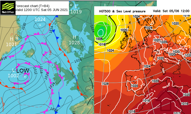
Temperatures - If the midweek temperatures have been too much for you, that change may be welcome, but SE Britain could hold onto the much warmer air even by the weekend. There is some uncertainty about where the Thursday/Friday cold front will end up, waving about by Saturday. You can see it marked north-south on the Met Office surface pressure chart just over Kent and Norfolk. On the GFS thickness chart higher in the atmosphere, the red colours of the warm air are bulging up through Europe and reach more into southern Britain at the weekend. The average for June for southeast England is around 19.5C, so still warmer than that if not quite matching the midweek figures.
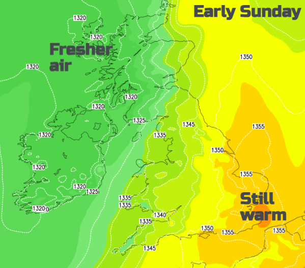
The nights have been mild, even warm this week. Friday night could be nippy for inland Wales and the far north of England. For Saturday night, fresher air will be over NW UK and temperatures look to dip well down into single figures for Northern Ireland and inland for the NW Highlands. The nights are so short at this time of year that it won’t be an issue but if you are camping or venturing out early on Sunday morning, you’ll need a jumper.
Wind direction - The winds will be from the west or SW at the weekend so cooler for the coasts of SW England and Wales but not as cold or foggy for eastern Britain. That will be an improvement.
Rainfall - NW Scotland looks wet with rain extending over Northern Ireland at times. Also, showery outbreaks for Wales, NW England and SW England later on Saturday but with fine weather in between. Central and eastern Britain look drier and sunnier, particularly on Saturday.