After a grey start, sunnier skies spreading from the west today, but showers developing too. Cloudy on Sunday, with rain spreading from the west. Back to showers for many most days next week, but hints of a drier & warmer Bank Holiday Weekend.
We are heading for one wettest Mays on record, with Wales recording double its May average rainfall already. An unseasonably deep low crossing the UK yesterday brought a windy and very wet day for many, again Wales seeing the highest rainfall, with Capel Curig recording 66 mm in 24 hours. While gusts of 65-75mph were recorded along southern coasts of England and Wales, the exposed Needles on the Isle of Wight recording a gust of 89 mph.
Saturday will see an improvement in the weather as low pressure moves away to the east, with a calmer, drier and brighter day, as sunny spells develop from the west, but there will be some scattered showers developing. Sunday may start promising, but rain and strengthening winds will arrive in the west in the morning before spreading east across all parts through the afternoon.
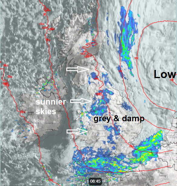
For now, a rather grey start across England, Wales and southern Scotland, more persistent overnight rain affecting many areas is now clearing the far SE of England, but grey skies and patchy rain still linger elsewhere. Windy along North Sea coasts of England. Sunnier skies across Central and southern Scotland, the Republic of Ireland and N. Ireland to start will gradually filter south and east across England and Wales through the morning, after the grey and damp start, though cloud, patchy light rain and brisk northerly winds may linger across eastern England.
Sunny skies will continue to spread from the west through the afternoon, with cloudy skies towards the east coast eventually clearing out into the North Sea, with the strong wind easing. However, scattered showers will develop, particularly across N. Ireland, central, southern and eastern England – where they could be locally heavy. But anywhere could catch a shower. Temperatures disappointing for late May again, reaching 11-14C, but with the best of the sunshine across south Wales and SW England – we could see 15-16C here.
Showers will quickly fade for most this evening to leave a mostly dry night with clear spells, turning chilly, temperatures low enough for a touch of frost in the north locally. Cloud will thicken across the west in the early hours, with outbreaks of rain arriving from the west across N. Ireland and the Republic of Ireland, showers developing ahead of this rain across Wales and western coastal areas of England by dawn.
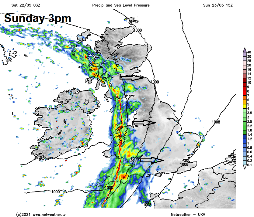
A new area of low pressure over the Atlantic will approach the west of Ireland on Sunday, frontal system ahead of this low will spread a band of rain accompanied by strong winds across western areas by the afternoon. Cloudy with showery rain developing ahead of this rain band across western areas during the morning. A drier, bright or sunny start for eastern Scotland and eastern England in the morning, before thickening cloud and showers spread in across southern and eastern England, the northeast likely staying dry and bright. A squally band of heavy rain will cross the Irish Sea into western areas early afternoon, bringing 2-3 hours of heavy rainfall accompanied by gusty winds. Cloudier and increasingly windy afternoon further east with scattered showers. Band of heavy squally rain reaching eastern areas during the evening. Highs well below average for late May, reaching 10-14C at best.
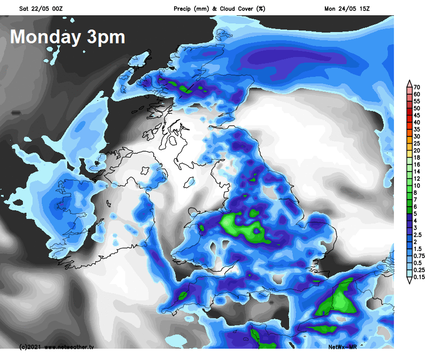
Band of rain clearing the east Sunday night, but lingering across northern Scotland through Monday, further south it will be a day of sunny spells but scattered showers developing, locally heavy with hail and thunder. Another cool day. Tuesday in a cool north to northwesterly wind, which will feed sunshine and showers southward, mostly across eastern areas – where they will be heavy.
Back to showers for many most days next week
Wednesday and Thursday staying on the cool side, with showers again in the north and east, perhaps more persistent rain for Scotland for a time on Wednesday. SW England and Wales drier and sunnier. Friday may see a band of rain move in from the west turn to showers as it crosses the UK.
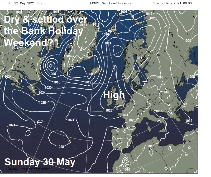
But into the Bank Holiday Weekend, the signs are still for high pressure to build, settling the weather down and also it should turn warmer, with temperatures reaching the high teens or even low twenties by day. But there could still be a few showers in places.