It's a bank holiday weekend, and true to form the weather isn't exactly being straight forward. Saturday and Sunday will see sunny spells and a scattering of showers. Low pressure arrives Monday, bringing wind and rain with it.
The weather this weekend has been well documented now, it's not going to be a total washout, but you may need to pick your moments if you're headed outside. Today (Saturday) and Sunday will see sunshine and a decent scattering of showers, then into Monday, with low pressure moving in, there'll be a spell of wind and rain to contend with.
Temperature-wise, we're going to be staying on the cool side by day, with more patches of frost overnight, following on from what was a cold April, with a frost recorded every day somewhere in the UK. With a bit of shelter from the breeze and during any sunnier spells, though, it should feel pleasant enough - it is now May after all, and the sun has a fair bit of strength to it. In fact, bear that in mind, as although it may not feel particularly warm in the wind, we'll still be seeing moderate UV levels, which is plenty enough to burn you after a relatively short time outside.
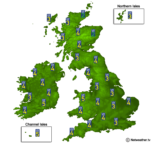 Check the UV levels in your location.
In terms of the weather detail, Saturday and Sunday will be close enough to throw a blanket over them. The mornings up to around lunchtime will generally be best for sunshine, as cloud bubbles up into the afternoons to allow increasing numbers of showers to break out. Not all will catch one, and in between, there should still be good sunny spells, but where showers do develop, they may be heavy, thundery and slow-moving. Temperatures will generally peak at 9-14c, slightly tempered by the breeze.
The showers will fairly speedily die out into the evenings, and with them, the cloud will also melt away. With clearing skies, that'll allow temperatures to drop away quite speedily, widely falling close to or below freezing. So, still not a good time to be planting anything delicate outdoors.
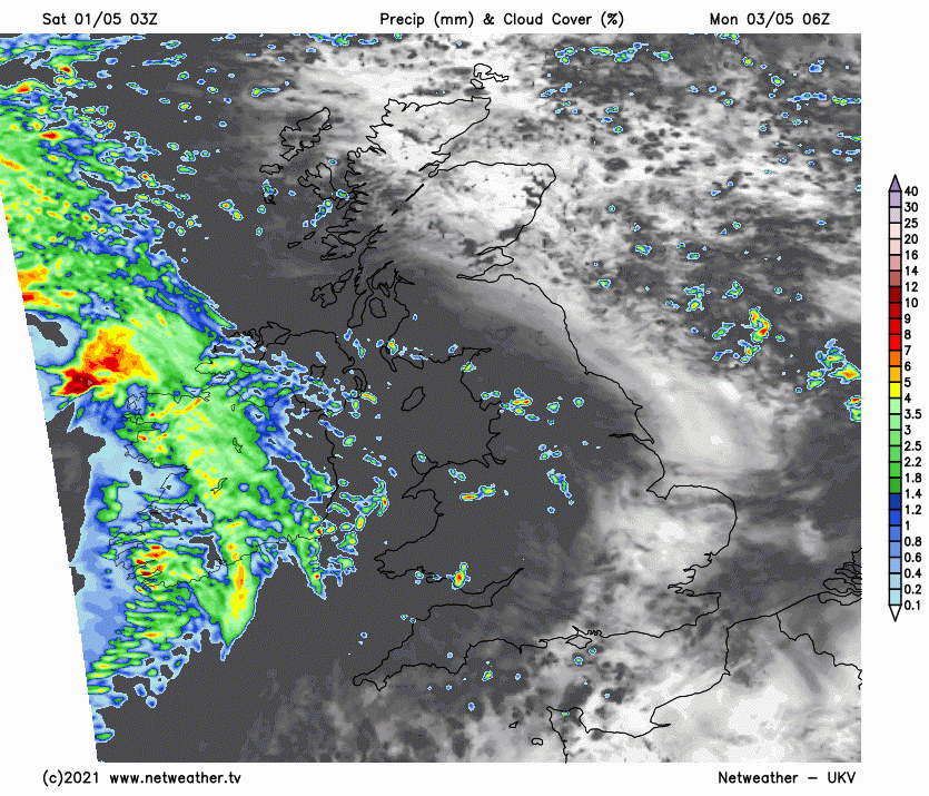
It's into Monday we see a real change taking place, and after an extended spell of weather that has been mostly devoid of any significant low pressure, it's going to be a bit of a shock to the system. Quite a vigorous low will arrive in from the Atlantic during the day, zipping across Ireland and then into Britain. With it, there'll be strong winds with gales in exposed spots - especially around the coasts and, in particular southern coastal counties. There'll also be a period of persistent and heavy rain moving through.
Ireland will start the day wet on Monday, but away from the western fringes of Wales and England, many parts of Britain will start dry with some bright or sunny spells in eastern and central parts first thing. The cloud and rain will spill in from the west quite quickly, with all but perhaps the far north of Scotland seeing it before the day is out.
Once that has cleared through, we'll be back to the sunshine and showers them on Tuesday, blown-in on blustery, chilly winds. If you're wondering about any signs of some summery weather, it's not looking great at the moment, with temperatures looking likely to stay below average through the first couple of weeks of May, albeit with some indications they may be starting to recover towards mid-month. It's Spring, though, which is one of the more unpredictable times of the year, so plenty of scope for changes to the forecast beyond 5-7 days.