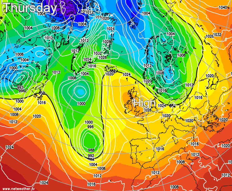
The dry April weather will continue as we end this week and move through the weekend, with high pressure never far away from the British Isles.
Droughts at this time of year are not unusual. We only have to look as far back as last April to see the problems a lack of rain can cause farmers and growers. And while the immediate prospects are for more arid weather, the final week of April should at least produce some showers. However, the nature of showers is that they are hit and miss in this very dry, mostly colder than normal spring so far. The number of frosts also continues to mount, so much so that we are now close to record levels for April, with more expected over the next few days.
So not surprisingly, we have a large anticyclone dominating the scene today. It's also been another very cold start, with temperatures first thing as low as -5C at Altnaharra and-4C at several locations across Scotland and North East England.
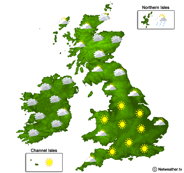
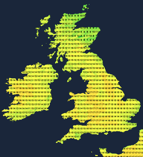
It'll soon warm up in the spring sunshine, and while some fair weather cloud will develop, most parts see a lot of sunshine today in generally light winds. The only exception will be the Western and Northern Isles, where more cloud may bring the odd light shower to Shetland. An East or North Easterly breeze that'll be fresh in the far South West keeps the South and, more particularly, exposed coasts of East Anglia and the South East cooler, but most parts become pleasantly mild. Temperatures will reach 16 or 17C over parts of North West England and West Scotland, but 13 to 15C will be a more general figure, with only a chilly 10 or 11C expected along some North Sea coasts South of The Wash.

For most, it's a fine end to the day with further sunshine into the evening and largely clear skies after dark. Mostly light winds allow temperatures to fall away quite quickly again, leading to yet another fairly widespread slight frost, with the lowest temperatures mostly in the range of –3 to +2C. A few mist or fog patches will also form in some rural areas towards dawn, but these will be short-lived, soon dispersing after sunrise. Although cold, an Easterly wind will help prevent a frost towards the far South West and along the South coast, with patchy cloud over northern Scotland still perhaps producing the odd light shower across the Northern Isles.
Our anticyclone remains in charge on Friday, so you can expect more of the same on another fine day, with lots of sunshine once early frost, mist and patches of fog have cleared. The Northern Isles should also see an improvement, with mostly just a little fair weather cloud by the afternoon for most parts.
It becomes pleasantly mild again, even quite warm for some in the West and North West, with top temperatures mostly between 14 and 18C but up to 19C in the warmest spots. Winds remain mostly light, but an East or North Easterly breeze across the South and South-West will continue to be fresh and gusty across The Channel Islands.
A fine evening in most parts is followed by a dry night with clear spells. It'll turn chilly again after dark, with patchy mist, fog and a slight frost reforming overnight, especially from Wales and the Midlands northward, where winds will continue to be light winds. But in the South, an Easterly wind, although cold, will help prevent a frost and patchy fog. Later in the night, parts of East Anglia and South-East, particularly towards the coast, may see a few patches of very low cloud rolling in off the North Sea, making it misty here by morning. Minimum temperatures –2 to +1C in the North with some sheltered Highland glens perhaps falling as low as –4 or -5C, with 2 to 6C more likely in the far South and South West.
It continues mostly fine and dry into the weekend with further sunny spells, but we'll be entering a period that's renowned for late wintry spells. And with the prospect of winds turning into the North again, it'll become colder by day. There'll also be some showers into next week that could even turn wintry on northern hills.