It might seem unbelievable after this week's warmth and sunshine but Easter weekend is looking much colder with frost, bitter north winds and even snow and ice Sunday into Monday.
Get ready for the colder part of the week with frost, ice and snow in the forecast for Easter weekend. March is over, with a top temperature on Tuesday of 24.5C in London. Yesterday was also very warm for much of England and Wales. North Norfolk reaching 23.9C at Weybourne, 23.7 in the West Midlands and 23C for Sheffield. Several locations broke their March records, but some medium/high cloud combined with Saharan dust just kept a lid on the temperatures in London and other parts of southern England so that the potential of 25C did not materialise. Still, it was very warm and but quite a change is on the way.
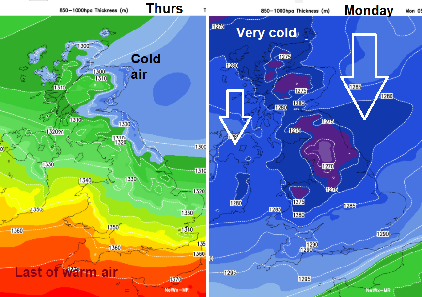
There are two significant cold fronts in the next few days. One has already made its presence felt over Scotland and Northern Ireland already. Temperatures in the north of Scotland barely reached 7C yesterday with more cloud and a nippy wind. It has been cooler overnight and there is a lot of low cloud and murk over eastern Britain now which has sneaked in from the North Sea. This will bring a change to colder air today for much of the UK, although taking its time to reach SW England where temperatures will still be into the high teens, maybe just low 20sC.
Then plenty of dry weather but feeling cooler, nothing like the warmth there has been before a dramatic change through Easter Sunday as an active cold front sweeps down from the north and opens up a bitter Arctic flow with widespread frost and snow for some.
Today
The warm flow from the south manages to cling on today for SW Britain but with a high pressure south of Iceland building our way, the flow changes to a cooler north-easterly. This means a drier spell for NW Scotland where it has been very wet for days. By this afternoon many areas will be fine and bright, dry with sunny spells as the morning cloud thins and breaks. The NE or east wind will make things feel cooler over southern Britain with a brisk wind for Kent, the Thames Estuary and Channel Islands. Shelter sunny spots will still feel okay, even warm for Cornwall across to Hampshire.
Overnight there will be some low cloud coming off the North Sea for eastern and SE England, also more in the far north of Scotland. Elsewhere it will be clear and cold with a frost, gardeners take note for Easter weekend. If the mice, squirrels or pigeons haven’t eaten your seedlings, they could do with frost protection.
Good Friday
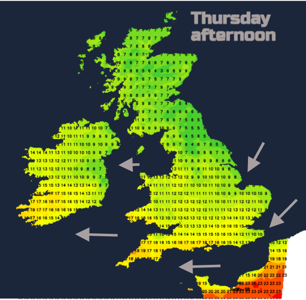
The east coast of Britain keeps a chilly breeze, more northerly so North Yorkshire, Norfolk and Kent coasts feeling that. Daytime temperatures will now only reach 9 to 13C for Good Friday. There might, in the coming days, be a little light patchy rain from thicker cloud but not amounting to much at all. The emphasis is on drier weather and then a cold plunge for the latter part of Easter weekend.
Saturday is settled and cool, still a nagging NE wind over SE Britain particularly Kent and a fresh westerly picking up for the Northern Isles over the top of the high pressure. Through Sunday that fresh west wind picks up through the day, first over Scotland and Northern Ireland, then later becoming windy for more of England and Wales. However, there will be a lot of fine, bright even sunny weather on Easter Sunday with lighter winds in the morning for England and Wales as the second cold front arrives further north.
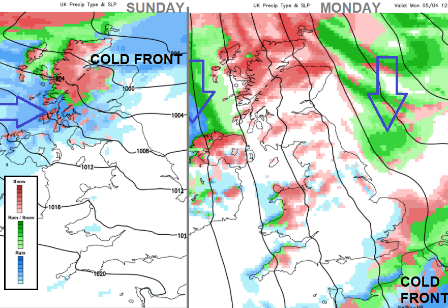
Though the afternoon and evening of Easter Sunday there will be rain, sleet and snow working its way southwards over Scotland and Northern Ireland, into northern England and north Wales with temperatures falling below zero. The winds reach gale force in the far NW, a bitter north wind bringing snow showers to exposed northern parts and wintry showers right down through the UK. The wind looks to be north to NNW so Northern Ireland, northern Scotland, north Wales and north coast of Devon/Cornwall all look exposed by Monday. If the wind veers slightly then the North Sea coast becomes more prone. Inland areas and southern England less so after the cold front has marched through on Sunday night/Monday morning. It will be cold Sunday night, Monday and Tuesday, feeling bitter in the wind with a hard frost, ice and wintry showers, including snow for some. Settling snow will be mostly for northern hills, particularly the far north of mainland Scotland (NW Highland and Grampians), even to lower levels and also northern counties of Northern Ireland.
The change from the warmth of Tuesday and Wednesday will be dramatic. Winter for Easter Monday. More chat and discussion in the Netweather community forum.