Our UK weather is mixed midweek with rain showers from the west, a cooler feel in the wind. However, much colder on Friday as the showers turn wintry with strong, gusty winds at the weekend.
There are plenty of vigorous low pressures away to the north of the UK, affecting Iceland then Norway and Lapland. Their weather front dangle over the UK bringing fast-moving bands of rain, blustery winds particularly for Northern Ireland and Scotland and by Friday an extraordinary low near the tip of Greenland will send a chill our way and wintry showers.
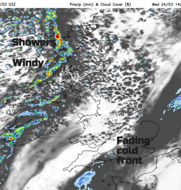
A weakening cold front is heading south-eastwards bringing more cloud and patchy rain. It starts over England, across Cardiff into the West Country but will spread to East Anglia by lunchtime, then the rain fades for the afternoon. Just more cloud over SE Britain with rain for the Channel Islands by this evening.
There is a small low pressure skirting past Scotland today as high pressure settles over central Europe. It will be windy in the far NW with lots of rain showers. The brisk SW winds will push a scattering of showers inland today although most will affect western Scotland and Northern Ireland. A line of heavier showers will arrive for the Western Isles and west coast this afternoon and bring a spell of heavier rain to the Central Belt by this evening. In-between all this there will be fine, dry weather with sunshine for Wednesday. Southern Britain keeps light winds from the SW then west as the front moves through. Temperatures today vary from 9C to 14C with a slight coolness in the air. It will still feel pleasant in sheltered sunny spots though.
Cool overnight with some clearer spots dipping near to zero but others staying at 6 or 7C.
Further little lows develop in the flow bringing lines of heavier showers or bands of rain, all of which sweep through west to east quickly. Western counties of Northern Ireland and the western half of Scotland see the most rain and the strongest winds whereas eastern Britain stays drier and often sunny or bright. Thursday will be similar to Wednesday but later in the afternoon, showery rain will spread over the far north of England with a line of showers extending from north Devon across to Suffolk.
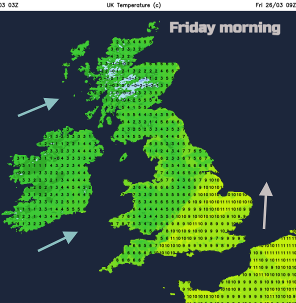
During Thursday night a low centred over Iceland will throw its cold front over the UK and bring a dramatic change in temperature. A short spell of heavy rain overnight. By day, SE Britain could see 11 to 13C for a time but behind the front, it will be single figures and feel colder. The frontal rain band takes its time to move across England no Friday down to London by mid-afternoon and the showers from the west begin to turn wintry. With an icy tinge, hail or sleet. Especially for the hills of Northern Ireland, Scotland, NW England then later for the Pennines, Peak District and north Wales.
Temperatures will fall to freezing during Friday night with further icy showers, sleet and snow over the hills. Don’t go digging out your sledge, these are fast-moving wintry showers with snow only really settling over the mountain tops. A few cms for the Peak District, Pennines and Southern Uplands, more for the NW Highlands. It will be a cold night in the wind with the dampness from the showers and the risk of ice.
For Saturday, we are in between systems, so a nose of higher pressure, a lull. It will be cold even with the sunshine and although not as many showers as on Friday, NW Britain will still see some, with wintriness on Saturday morning. Otherwise, wrap up warm and it will be a glorious looking day with sunshine but a nip in the breeze.
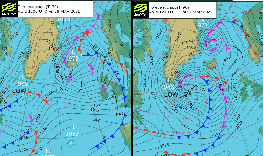
This will all be short-lived as the cloud soon increases from the west. That extraordinary low pressure near Greenland, it’s marked as 989hPa Friday 12z and 948hPa Sat 12z.
“A low pressure system whose central pressure falls 24 millibars in 24 hours in a process known as explosive cyclogenesis.” Met Office.
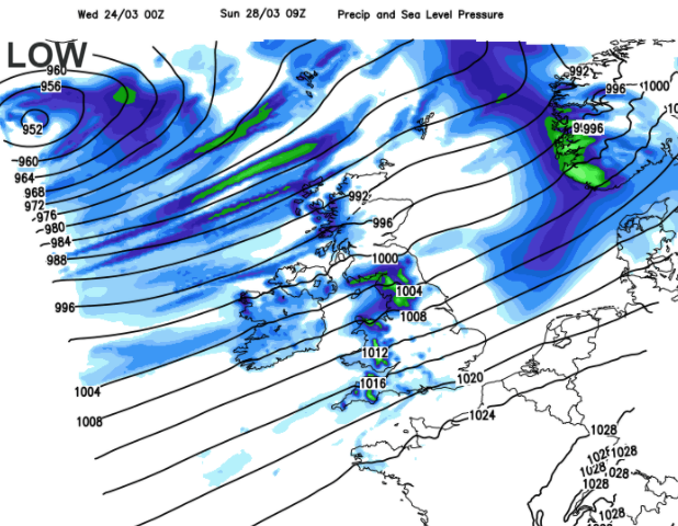
If that was incoming to the UK, we’d have major wind warnings with talk of a stingjet with disruption and damage, maybe even a storm name. But it’s not, the jetstream is still quite far north keeping these low centres away. It deepens away over the north Atlantic so nothing that dramatic for us, but it will bring a spell of wet and very windy weather to the UK this weekend into Monday.
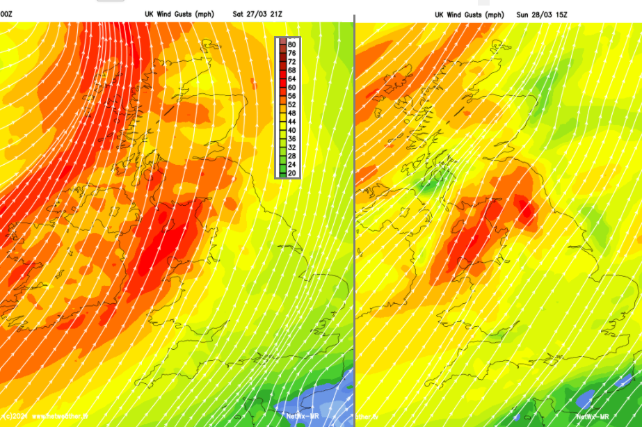
There is some uncertainty about the position of the rain band on Sunday. NW UK looks to see spells of rain whilst the SE stays drier. It won’t be as cold but there will strong gusty winds starting later Saturday and overnight then building again on Sunday afternoon and staying windy into Monday. Might do to secure things on Saturday in the lull.