Today marks the Vernal Equinox, the start of astronomical spring, when days and nights are of equal length. High pressure in charge this weekend will ensure most will be dry with some pleasant sunshine for some, but often rather cloudy.
It’s the Vernal (spring) Equinox today, the start of astronomical spring (vernal means fresh or new – like spring). It is one of two moments in the year, the other during the autumn equinox on 22 or 23 September, when the sun is exactly above the equator, with day and night equal in length. Astronomical spring lasts until the summer solstice on June 20 or 21.
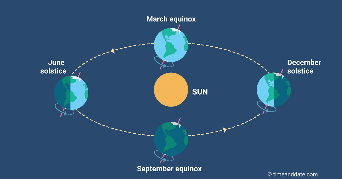
Credit: Timeanddate.com
Will the weather be spring like? High pressure will be in control of our weather over the next few days, so for most it will remain calm and dry, however, as if often in early spring, there will be a lot of cloud moving around the high, so it won’t be sunny for some at times. However, where the sun does come out, it will feel pleasant. The northeast of Britain will see the best chance of sunshine today, we could see temperatures reach the mid-teens across NE England. Large amounts of cloud floating around on Sunday too, but perhaps a greater chance of seeing some sunshine for many compared to today.
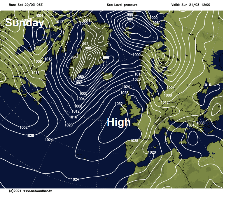
For now, dry but rather cloudy across many areas this morning, a little drizzle in a few spots. High pressure has retreated west today allowing more of a northwesterly flow, which means milder for eastern areas which saw a cold northeasterly flow off a cold North Sea over the last few days. But the northwesterly flow brings with it weak weather fronts producing a rather cloudy day for many, cloud thick enough to bring some drizzle across western areas. Also, a cold front moving down across northern Scotland will bring some rain this afternoon and evening.
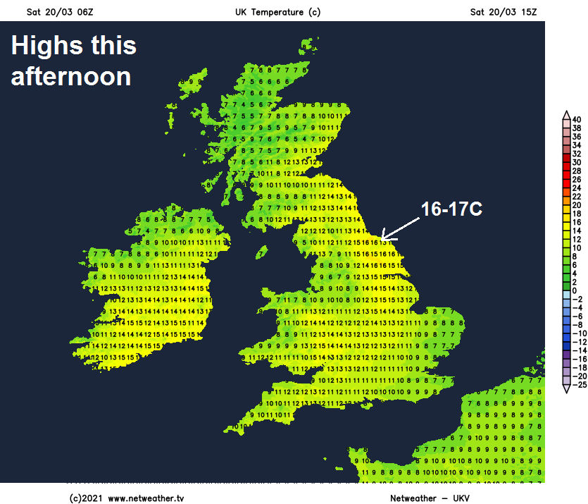
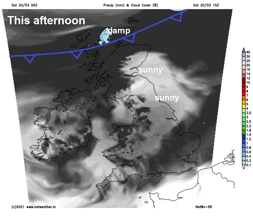 But it will remain dry for most and for eastern Scotland and NE England, with shelter of higher ground to the west, clearer skies are likely, so some good spells of sunshine are likely here. Sunny for the Channel Islands too. Temperatures reaching the mid-teens for the northeast in the sun, perhaps 17C in the Vale of York. Elsewhere, on the cool side, temperatures reaching 10-12C at best.
It will remain mostly cloudy but generally dry tonight, though cloud thick enough for the odd patch of drizzle in places, as a weakening cold front moves south. Some clear breaks developing across central and southern Scotland along with northern England as the cold front clears south from here.
Weak cold front across the south at first on Sunday, bringing generally cloudy skies during the morning across central and southern England along with Wales. However, brighter skies with sunny spells in the north will spread south across most parts into the afternoon, though the far south and far north may stay cloudy, with patchy drizzle across northern Scotland. A cool day for all, following the cold front clearing south, particularly in the northeast where we see some warmth today in the sunshine, temperatures reaching 8-12C.
The area of high pressure bringing the settled conditions will continue to influence our weather early next week. Clearing skies Sunday night will lead to temperatures falling towards freezing, leading to a frost in places to start Monday, which will be a mostly dry day. Bright or sunny at first, but any sunshine becoming confined to southeast Britain, turning cloudier elsewhere. Tuesday dry and bright across southern England, cloudy elsewhere, increasingly windy across the north, with some patchy drizzle or rain moving in across the northwest.
Turning more unsettled and breezy or windy across most parts from Wednesday, as Atlantic frontal systems roll in from the west. However, most of the rain or showers look to be across the north and west, rain perhaps heavy in the longer spells, rain generally light and patchy when it reaches eastern and southeastern areas. Temperatures will generally be close to average, staying in the low teens Celsius by day. Generally frost-free at night.