Sunshine and blustery showers will be the weather theme this weekend, and it'll be chilly enough for some snow up over the hills of Northern Britain.
After coming in 'like a lamb', we've seen the other side of March over the past few days with rain and gales. And the weather remains 'like a lion' particularly today, before eventually settling down again from about Wednesday of next week.
Some hilly parts of the North have seen some snow at first this morning in another day of sunny intervals and blustery showers, once an area of showery rain has cleared from the North of England and the North Midlands. Some of the showers over Northern Ireland and in the West will be heavy, giving hail, sleet and perhaps local thunder, with the showers continuing to fall as snow on northern hills. But in the East, there'll be fewer showers, where you'll see the best of the sunshine by the afternoon.

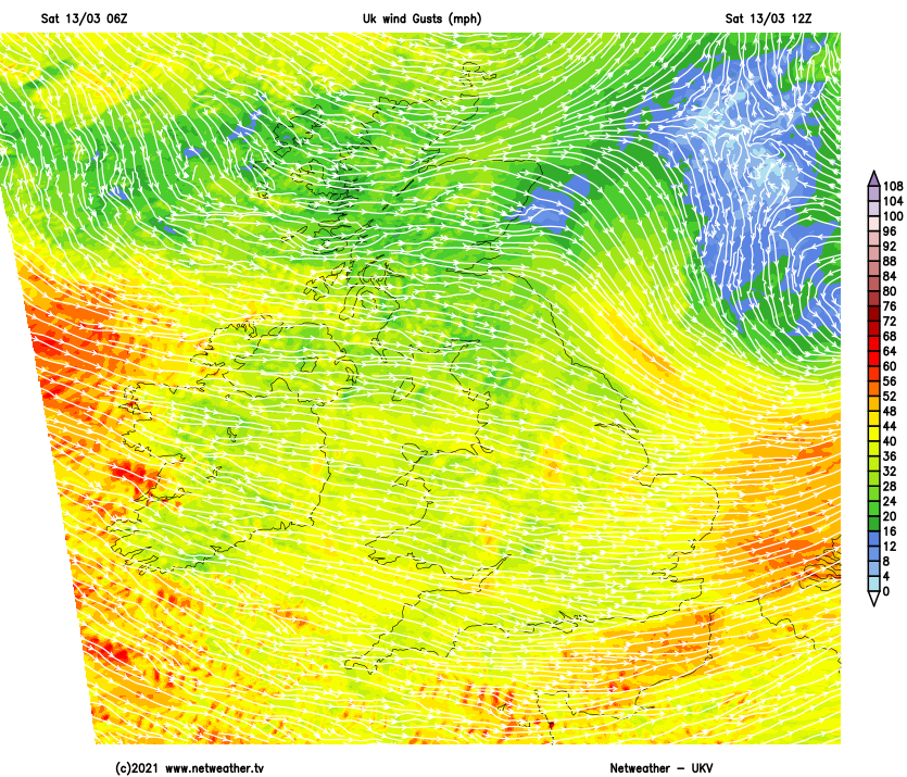
A blustery West or North-West wind will be fresh or strong, especially in the South at first, giving gale force gusts in excess of 50mph in some of the more squally showers. These will be accompanied by sudden falls in temperature, making it temporarily feel cold and quite raw, but in the sunshine between times, temperatures reach 6 to 8C in the North and 8 to 10C further South.
Blustery showers continue after dark, some wintry over Scotland and in the North mainly giving hill snow. But into the early hours, they'll become lighter and fewer from the West as a weak transient ridge moves in. This'll allow clear intervals, and as winds decrease somewhat, parts of Scotland and a few sheltered rural areas further South may see temperatures falling close to freezing, giving a touch of frost. Still, the wind should prevent temperatures from falling below 2 to 5C in most parts.
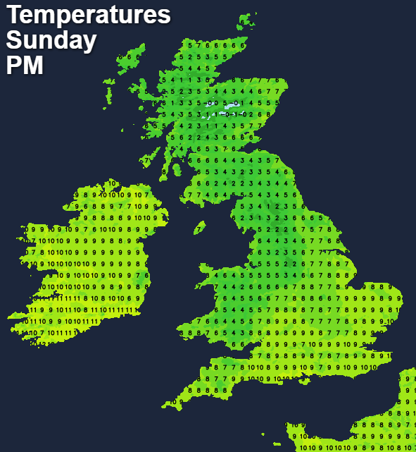
Central and eastern areas begin fine but cold on Sunday with some sunshine. Apart from a few wintry showers towards Moray and the Northern Isles, much of the North and East of Scotland have a bright if though a rather cold day. But in the South and West, particularly towards Dumfries and over Northern Ireland, it'll turn wet during the morning. The rain will be preceded in places by hill snow, with the rain spreading to Wales and North West England through the afternoon. Towards dusk, the generally showery rain will be 'knocking on the door' of the South West and more eastern areas, but apart from increasing cloud, much of the day here will be dry.
Winds over Scotland except the far North East will be lighter than of late, but it'll feel cold, with top temperatures here only 4 to 7C. It also won't be quite so boisterous further South, but a West or South-West wind will still be quite fresh. This too will feel chilly, but temperatures across England and Wales should reach 8 to 11C.
England and Wales have a breezy, showery evening before turning somewhat clearer and colder from the North overnight. Elsewhere a cold and gusty North West wind brings a scattering of showers mostly to the North and East that'll be wintry in places giving hill snow. There'll be a frost in some sheltered places with the lowest temperatures close to freezing, but 2 to 4C should be a more general figure.