Temperatures will be above average for much of the week, with spells of rain or showers affecting all parts everyday, perhaps very mild this weekend, with temperatures reaching 17C in eastern England.
Well, what a contrast Monday was compared to the previous 7 days of bitterly cold and snow for some. Mild Atlantic air shoved the cold out to start the week. Tuesday will be another mild day, with rain clearing eastern areas followed by sunny spells but also showers spreading east, gales affecting the far northwest. It will remain mild for the rest of the week, further spells of rain will spread northeast across all areas on Wednesday and Thursday, more rain for the north and west on Friday, though southeastern Britain likely staying dry. By Saturday, low pressure to the west and southwest will draw mild air from a long way south, so parts of southern Britain could see temperatures as high as 17C.
For now, it’s mild everywhere to start the day, further rain had spread northeast overnight, a band of rain lies from Dorset and Hampshire up towards Lincolnshire, it will clear east the next few hours but may linger across the far SE of England until mid-afternoon. Elsewhere, sunny spells developing from the west through the morning, but there will be a scattering of heavy showers for the west and northwest in particular, some of these getting further east across central and southern England, but eastern Scotland and most of eastern England should stay dry and sunny.
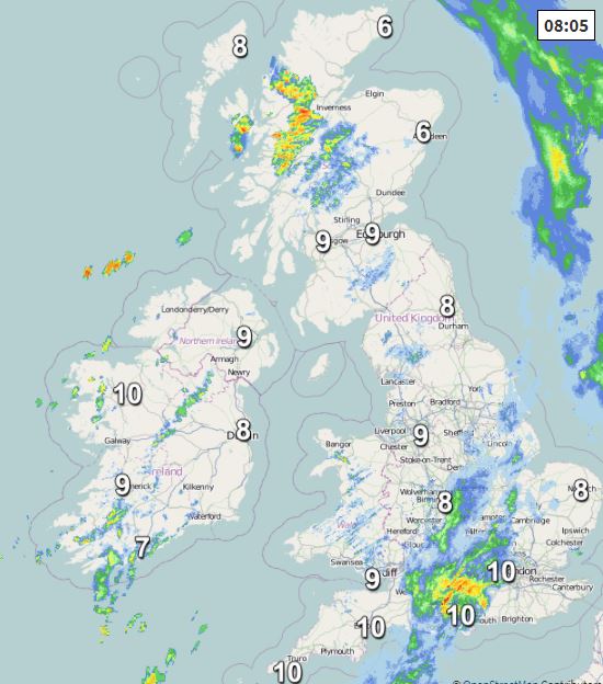
Temperatures reaching 10-12C widely. A breezy day on the whole, but particularly windy with gales across NW Scotland – where a wind warning is in force for gusts of 60-65 mph, isolated gusts of 70 mph.
Scattered showers for a time across England and Wales before fading to drier conditions with clear spells for most areas, however, winds will strengthen from the west, while a band of rain pushes in across Ireland and N. Ireland overnight, before reaching western areas of mainland UK before dawn.
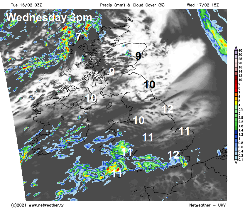
An area of low pressure will move in to the northwest of Britain tomorrow, sweeping cloud and outbreaks of rain across all parts during the morning, brighter skies, with sunny spells moving in from the west across the north from late morning, but it looks to remain dull with further outbreaks of rain spreading in from the southwest across south Wales, central and southern England in the afternoon. Cooler across Scotland, N. Ireland and far north of England, with temperatures reaching 7-9C, milder further south – with temperatures reaching 10-12C.
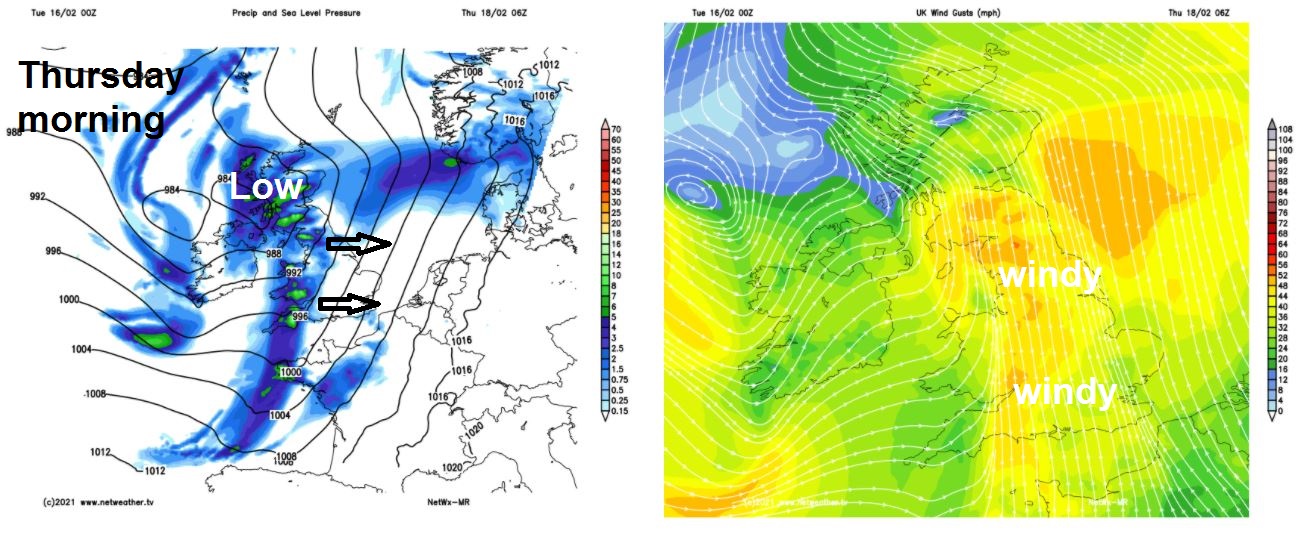
Wednesday night turning wet and windy across the west, as a deepening area of low pressure tracks northeast across Ireland towards Scotland by breakfast time. A spell of heavy rain is likely for Ireland, N. Ireland, Wales and eventually Scotland during the morning – where it will turn to snow over higher ground as cold air cuts in from the northwest. A brief spell of rain along a cold front moving east across England. Windy everywhere on Thursday, rain and hill snow clearing Scotland in the afternoon, while brighter skies follow the spell of morning rain from the west further south, but with showers in the west. Turning colder across Scotland and N. Ireland, with afternoon highs reaching 5-7C at best, but further south highs reaching 8-11C.
Windy and cloudy with further rain spreading northeast across most areas on Friday, though SE England and East Anglia could stay dry. With the wind from the southwest, it will be quite mild, temperatures ranging between 9C in north of Scotland to 13C in the south.
Southwesterly wind sourcing warm air from a long way south on Saturday, so with dry and sunny conditions currently showing across SE England and East Anglia – we could see temperatures reach 16-17C here. Cloudier across northern and western areas, with outbreaks of rain probable here. Sunday perhaps seeing further rain spread north, heavy across the west, followed by drier conditions, rather mild again.
While it was rather cold in the UK up until last weekend, cold of a more brutal kind has swept as far south as the Gulf of Mexico in the USA, with southern states seeing colder conditions than most of the UK have during the recent easterly: