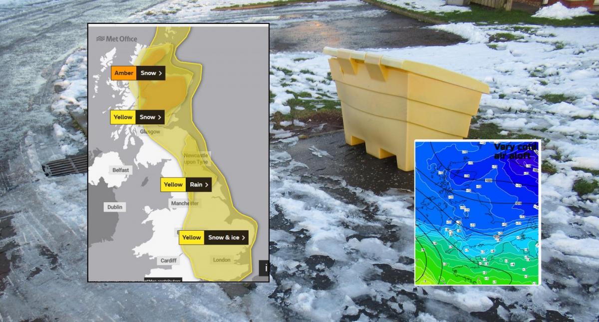
Scotland continues with cold winds, snow and even blizzard conditions into the weekend. Gradually the cold air spreads over more of the UK and the snow shower risk from the North Sea extends southwards.
We have a spell of much colder wintry weather for February with an easterly flow which will bring snow. It is already chilly in the north and as much colder air approaches the UK from the northeast, the rest of the country will turn colder. This brings the risk of ice and a wider chance of snow through the weekend into next week, particularly for eastern Britain.
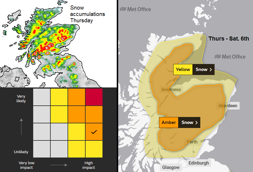
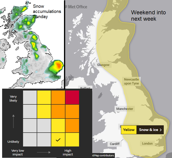
Parts of Scotland are already seeing significant snowfall, it has been very wet and sometimes wintry for other parts of northern Britain and Northern Ireland already this week and northern mainland Scotland has an Amber warning for snow running from Thursday afternoon until at least Saturday morning. Further warnings or upgrades are expected.
There is still an awful lot of water about, still raining in places and more overnight with flood alerts and warnings continue. But the forecast for snow will include substantial and disruptive snowfall with bitter cold. There are similarities to the Beast from the East setup in 2018, although that depth of brutal cold, longevity and immense snowfall is not expected.
“Snow will become persistent and heavy and could lead to some significant disruption to transport and utilities." MO
There is already snow falling on lying snow, the winds are strong and gusty blowing it all about. Snow will reach down to lower levels through Aberdeenshire, Moray, Caithness and Sutherland, Cromarty. And the impacts from this are marked as High on the warning matrix.
“The strong easterly winds will likely lead to drifting snow, temporary blizzard conditions, and ice forming on exposed power lines and phone masts. Persistent snow should ease on Saturday, though snow showers will follow.”
Locally people have been advised to prepare and “”If you deem your journey really is essential, plan ahead and make sure you and your vehicle are suitably prepared by having sufficient fuel and supplies such as warm clothing, food, water and charge in your mobile phone in the event you require assistance.
As the cold air takes hold over more of the UK the easterly winds will allow snow showers to develop over the North Sea, lake or sea effect snow in action. There is a widespread warning for snow and ice.
“Snow showers in the far north-east of the UK will spread southwards. Chance of heavier snow for a time in the south. Snow showers for many with a cold easterly wind. Disruption to travel is possible.”
And lines or clusters of snow showers will be piling in from the east. It won’t affect everyone and to understand that, it is worth looking at the radar images from the last Beast from the East set up. The image below shows late February, snow showers on a east to NE wind. There are gaps, areas that stay dry but others seeing plenty of snow. The start of next week looks similar.
If you are under one of these lines (or streamers) which just keep on feeding snow in, then the totals rise quickly. But a few miles north or south there could be very little snow. During Saturday as the low centre moves along southern Britain, more areas feel the easterly flow with a north-easterly wind into Anglia and SE England.
So, there will be a time of transition when precipitation is rain, icy rain and sleet then snow for England during Saturday and overnight into Sunday. Worth noting in the warning for England.
“In addition to the showers, there is a chance that an extended period of more persistent snowfall could impact parts of the Midlands and southeast England overnight Saturday and through Sunday. This is all likely to bring areas of accumulating snow through the period with some icy stretches developing, with some parts seeing 5-10 cm, possibly 15 cm of snow. “ With disruption likely. East Anglia is looking prone on current forecasts.
At the weekend and then right down through eastern Britain by Monday, north Kent looking prone in the north to northeast winds, all the time snow showers being driven in off the North Sea, easterly winds for Scotland, more NE For England. Some will reach far inland on these brisk winds, get a new lease of life over the Irish Sea for eastern Ireland. Remember these are all warnings of severe weather, they are impact-driven so the timing of heavier snow maybe a factor, if it falls at night for example. And not everywhere in the warning area will see heavy snow, also places outside of the warning areas could get snowfall.
If your weather app shows heavy snow when you look at it in the morning but by the afternoon it shows drier even brighter weather for the time frame this is because it can’t deal with the fine detail (resolution) of the showers for next week yet.