Colder and milder air masses have been regularly battling over the British Isles for a while now, and that battle is going to continue to rage this week.
Colder and milder air masses have been regularly battling over the British Isles for a while now, and that battle is going to continue to rage this week. There'll be more spells of rain, sleet and snow with some sizeable snow accumulations for some across the northern half of the UK, whereas further south rain and further flooding are more of a concern. Towards the end of the week and into next weekend it does look quite likely that the cold will win out and move south, but although many of the forecasting models show this solution, not all of them are, so there are still some questions to be answered around this.
At shorter range, after a cold, frosty start for many, it'll be a mostly dry day for the majority with some sunny spells, although it will feel cold in the wind. There'll be some wintry showers affecting eastern coastal regions of Scotland and Northern England, but it's further south and west where the most action will be as patchy rain, sleet and snow continue to affect Ireland (North and South) through the day. Some of that will also work its way up into southwest England, Wales and later other parts of southern and perhaps also central England. In Wales, a good deal of it will be sleet and snow inland, but elsewhere the wintriness will be more limited and rain more common, with higher ground always the most likely to see snow.
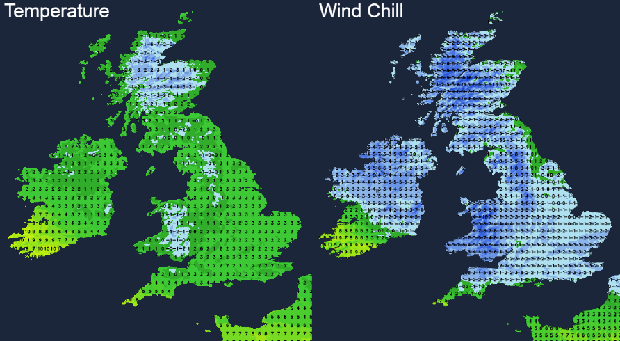
Temperatures will struggle in the main, reaching 0-3c widely and once you take the wind into account, it'll feel sub-zero just about everywhere. The southwestern corner of Ireland and the very far southwest of England will buck the trend and stay milder though, with double figures not out of the question.
Overnight, the patchy rain, sleet and snow will ease in southern and central areas, but wintry showers will continue to affect the northeast, particularly Scotland. It'll be another cold, frosty night for many - especially across the north of the country and into Wales.
The start of Monday will keep some of those wintry showers coming in the far north and northeast, along with some outbreaks of rain in the southwest with some wintry bits and pieces perhaps getting up into south Wales and the Midlands as well. It will generally fade during the day, but at the same time, another spell of rain will start to gather itself and move northeast through Ireland, turning to sleet and snow as it meets the colder air further north. By late afternoon or early evening, it'll cross over into southern and western Scotland as well, readily falling as snow here and perhaps also affecting the far north of England.
That will just be the welcoming party though, as a further set of fronts will move up from the southwest during the evening, all tied in with an area of low pressure which at that point will be just out to the west of Ireland. That's going to bring rain with across Ireland then into southwest England, Wales and the Midlands during the latter part of the evening and the first part of the night. But then, as it meets the colder air from the north Midland northwards, the rain will start to fall as snow. It'll be the hills above 150m seeing the lion's share of the accumulating snow, with 10-30 cm likely, but even lower down, several cm's are possible in places.
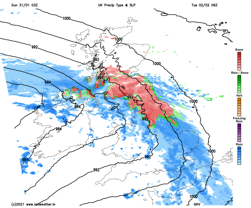
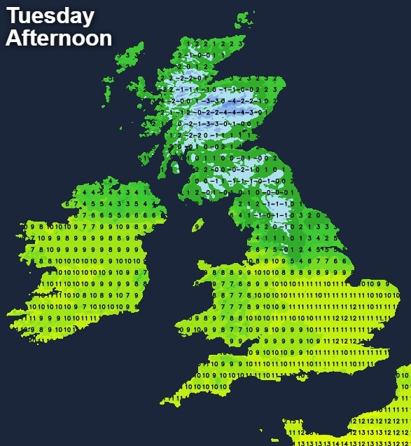
It'll be a messy picture on Tuesday as the rain, sleet and snow continue to move northeast bringing some further sizeable falls to the north of England along with southern and central Scotland. Simultaneously, milder air will make inroads north, causing some snowmelt across the southern part of Northern England, as more showery but heavy rain moves into much of England and Wales. It'll be another of those days with a really big temperature difference north to south, and a sharp gradient along the boundary of mild and cold.
The messiness continues into midweek with further outbreaks of rain, sleet and snow as one low pressure crosses the country and moves away east, but another sits just out to the west, with that boundary of mild and cold still straddling the country. From here where we start to see some forecasting model divergence, many of them take that second low southeast in towards the continent, which invites colder air and easterly winds south across the UK. But, others (chiefly the ECMWF) bring the low in over the UK, keeping the really cold air at bay. At the moment, the colder scenario has the most support and is the most likely, but it's a complex picture and one we'll have to keep an eye on during the next few days to see which direction it all goes in.
Whatever the latter part of the week does, there's plenty of action in the meantime with weather warnings already issued by the Met Office. The flooding situation is also a concern, with more rain likely exacerbate that.