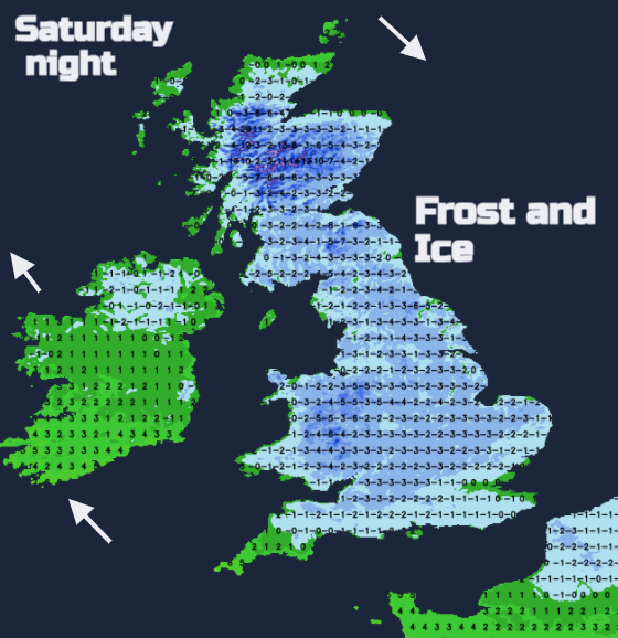
Frost and Ice become more widespread as the cold air spills southwards. Passing Storm Justine brings rain from the SW by Saturday and the possibility of snow. Feeling cold as the winds strengthen.
Another tricky rain/snow situation in the forecast for the south this weekend. Friday starts with continuing rain and hill snow over northern Scotland. There is a rotation of showery rain centred over the West Country which will head away from Wales to southeast England this morning and still there is a distinct temperature contrast north-south. Coming up next will be Storm Justine to the south of the UK. More later on why this is 'J' not 'D' for the storm name after Storm Christoph.
There are already rain warnings for SW England late Friday into Saturday and a not-so-certain snow warning over Wales and the Midlands. There is low confidence about how far north the frontal band will reach and how it interacts with the colder air to the north to actually produce snow on the leading edge. But still a bit of white stuff excitement in the forecast for England and Wales.
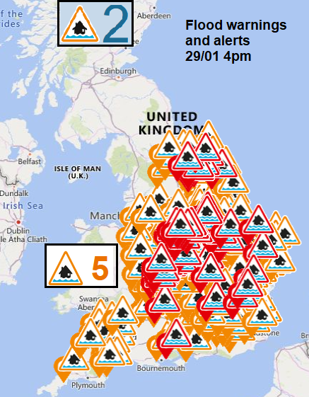
All this rain continues to bring flooding concerns. Some rivers are still at high levels from last week’s rain never mind the bands coming in now. The Environment agencies again highlight the risk of Local flooding from rivers and surface water. Over the next few days, the precipitation is concentrated over SW Britain. So, Wales, particularly the south and SW England seeing a lot of rain. The mountains and hills of Wales seeing some snow and then uncertainty about if the rain and maybe more hill snow edges into southern England, up to the Midlands or over Northern Ireland. And for Saturday, will there be a spell of snow even to lower levels. This leaves a drier picture further north over Britain and possibly for Northern Ireland through the weekend and on Monday.
The cold air will spill southwards, taking its time to reach Devon and Cornwall on Saturday but there will be widespread frosts and with blustery winds at times that will make it feel much colder. Quite a change from the mild air today.
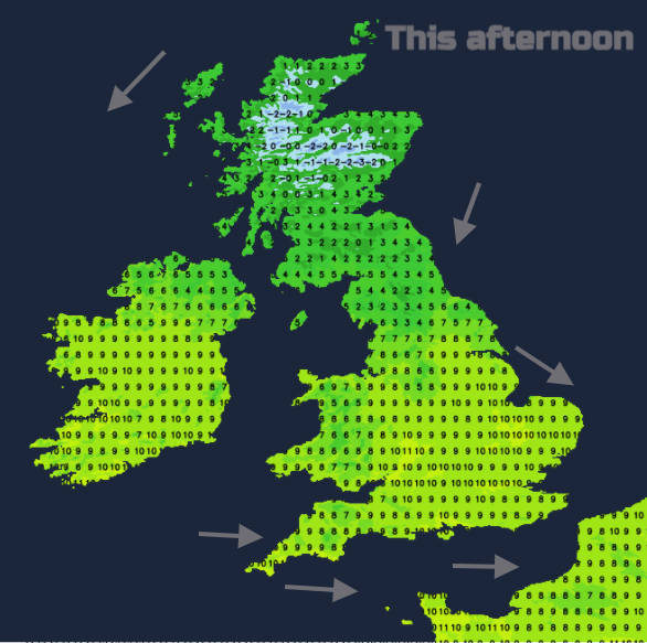
The showery rain whirling around southern Britain this morning will move across to London and the southeast before lunchtime and leaves drier, brighter weather behind. So, an unsettled start but improving and feeling mild out of the westerly wind at 9 to 11C. For Northern Ireland, it will be a fair day with a few showers clipping the north coast. Light winds from the NW veering to the NE and temperatures of 7 or 8C. Central Britain will be fine too with bright spells with a cool breeze but temperatures of 7 to 9C. For Scotland and the far north of England in a NE wind, it will feel chilly and damp. Temperatures of 3 to 6C as the frontal band fades a bit. Sunshine for the far north of Scotland and an improving picture in the NW as the cloud, hill snow and patchy rain pulls over SE Scotland and NE England, all the time becoming more showery. This leaves a cold, icy night for northern Britain with a hard frost for the Highlands and light winds.
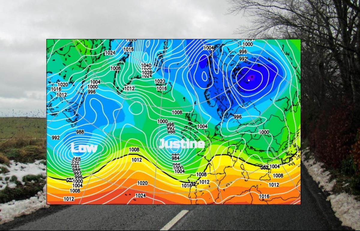
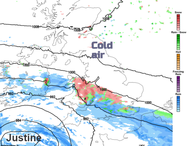
Next, we look to the Atlantic, a deepening low pressure which has been named Justine by the Portuguese Met Service, a bit keen in the SW Europe storm naming group. This list included snowy Filomena that hit Madrid earlier this month and Hortense last Friday which headed to the central Med. Storm Justine will affect France and Spain with weekend wind warnings and stormy conditions for the Bay of Biscay. Before that, for the UK it will bring rain in the south, this risk of snow and strong winds as it moves by on Saturday.
Winds
The easterly winds pick up early on Saturday, strengthening through the day with coastal gales through the English Channel and Celtic Sea. This wind will add to the colder feeling during the day. Later the winds ease down in the north allowing a much colder night with clear skies, but the strong winds continue for the Channel Islands.
Rain
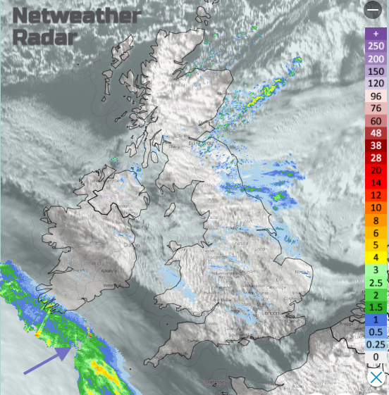
The Met Office rain warning over Cornwall and Devon runs from this evening until Saturday afternoon, that may well be widened in area this morning. The frontal band of rain edges up through Wales into more of England (the south, the Midlands, East Anglia) and encounters the cold air.
Snow
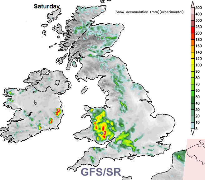
The GFS based SR model shows snow appearing before dawn along the frontal band. The UKV model only has snow over the Welsh mountains but show more by mid-morning across a swathe of Wales and southern England. To the south and SW, it remains as rain. The band nudges northwards for time and then retreats south again. The timings on a weather app and whether it shows snow or rain should be treated with some caution unless you are in the Cambrian mountains and can assume snow.
As Storm Justine pulls away along the west coast of France it leaves a clear very cold night for the UK with a fine, bright but cold Sunday. More rain will reach SW England from the next Atlantic low spilling into south Wales and southern England later in the day and perhaps again bringing the risk of snow. The air will be cold ahead of this front. Plenty to keep snow lovers in the south on their toes this weekend.