Rain with hill snow spreading in from the west on Tuesday as milder air tries to make a return. It won't fully win out though, with the cold hanging on further north.
It's an icy start particularly where snow is still lying, but milder air is moving in bringing a thaw. After a bright start in some eastern areas, it's already turning milder in the South West, West and over Northern Ireland, where we have some rain preceded by a little mostly hill snow. Through the day the rain and hill snow work their way North and East, to reach all but the North and parts of central Scotland before dusk. It'll be misty at times in the rain that'll begin to clear from the West later. Apart from the odd wintry shower and a little snow mostly over Fife at first, the North of Scotland sees some winter sunshine. But it's a very cold start, -7C at Altnaharra to begin with.
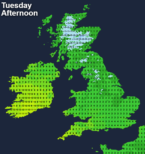
Light winds over Scotland and in the North and East at first freshen from the South East or South making it feel raw, with temperatures here struggling to reach 3 to 5C. Elsewhere 6 to 8C is more likely, with the South West reaching a mild 10C.
Much of Scotland stays cold after dark, with a raw North wind bringing a few wintry showers mostly to Moray and Aberdeenshire. Any rain or snow over the South of Scotland will peter-out allowing skies to break from the North later in the night. Lowest temperatures here -2 to +2C giving a frost mostly in the North. It'll also become drier elsewhere with skies breaking, but it won't be as cold as on recent nights allowing remaining snow to continue to thaw. Lowest temperatures 3 to 5C but 6 to 8C towards the South West in a lighter South West or southerly breeze.
Wednesday sees a fair amount of bright weather over the country with sunny intervals, although cloud amounts will vary. But apart from the odd shower, which will be wintry over Scottish hills and in the far North and North East, it should be mainly dry. Maximum temperatures 6 to 8C, but only 3 to 5C across the North and East of Scotland. Towards the South West, however, it'll be milder with temperatures closer to 9 or 10C. There'll be some rain or drizzle moving in again, which will probably spread to parts of the West Country, Wales and perhaps Northern Ireland before the day is out. Mostly light winds at first will freshen in the West from the South.
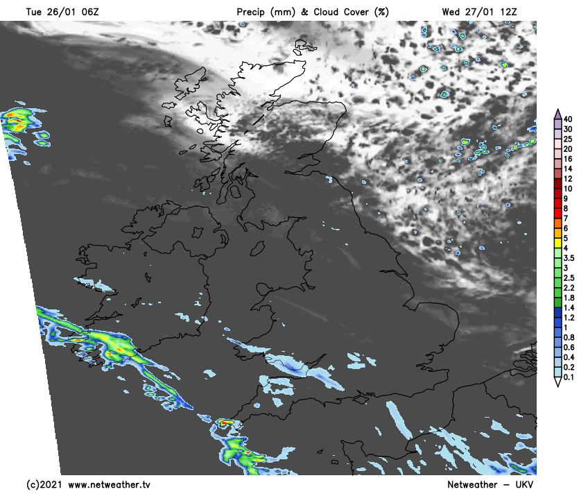
Apart from a few wintry showers across the North and East of Scotland, it should stay mostly dry after dark, although the South could see some rain, and mostly hill snow moving in towards morning. Lowest temperatures in a freshening East wind later in the night, around zero to +2C giving another frost in places. North and North East England may also be quite cold with mostly hill snow, as outbreaks rain and strengthening southerly or South-East winds 'sweep' northward across the country. Further South though it'll be milder with temperatures mostly in the range 4 to 9C.
It remains unsettled and windy until Friday with a North/South split, as very cold polar and much milder Atlantic air continue to battle for supremacy. There'll be further rain and snow in the North, while the South sees occasional rain or showers. But during Friday most parts turn colder from the North, with a drier start to the weekend to follow when frosts and perhaps patches of freezing fog return.