A look at the risk of snow and ice over the weekend, with Met Office warnings in force for parts of the UK, as cold polar air digs in from the northwest.
Storm Christoph on Wednesday brought a month’s worth of rain in the space of a few days across parts of northern England and Wales. Although for many it will be drier then we’ve seen over the next few days, there’s still a lot of water from the recent excessive rainfall yet to feed downstream through river systems, so the flooding risk remains over the next few days across Wales, northern, central and eastern areas of England.
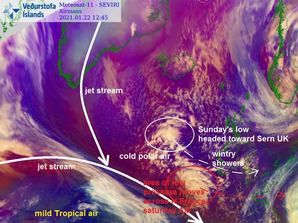
Colder polar air has moved in across the UK and Ireland in the wake of Storm Christoph which is now over Scandinavia, with the polar front jet stream displaced to the south of the UK today and through the weekend. So it will remain on the cold side, in fact it will be colder than today over the weekend.
Although it will remain dry with some sunshine for much of the time today and through the weekend, there will be wintry showers around feeding in on the cold westerly or northwesterly flow. A more organised area of sleet and snow, associated with a low pressure system, looks to move across the south on Sunday.
Source: wxcharts.com
For the rest of today showers that have been in the west this morning will spread across Wales and England to the east of England later, showers mainly of rain or sleet at lower levels, snow over higher ground in the west, perhaps snow to lower levels across N. Ireland and western Scotland as colder air arrives here, but also showers could turn to wet snow on the back edge as they reach the east after dark when temperatures will fall quickly.
Wind veering northwesterly on Saturday, which will continue to feed in rain, sleet and hill snow showers across western areas in the morning initially, but some of these showers will reach the east too in the afternoon – where they could fall as snow away from southern coastal areas as the northwesterly flow brings in colder polar air.
The Met Office have a yellow warning for snow and ice in force for today and Saturday covering the risk from these showers bringing some accumulations and the associated risk of ice as temperatures fall close to freezing overnight.
Showers will continue at times across many areas, these largely of rain and sleet at low levels across southern England and southern Wales and near coasts but will be of sleet and snow elsewhere. These will bring a cover of snow in places. 1-3 cm could accumulate at low levels, mostly across Northern Ireland, Scotland and northern England but as much as 5-10 cm of additional snow may accumulate at higher levels of these areas. Clear skies between showers will also bring the threat of ice.
Source: Met Office warnings
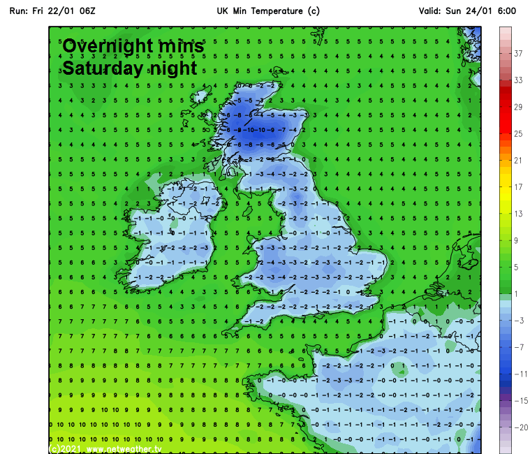
A widespread frost tonight and Saturday night will bring a risk of ice where showers have fallen, temperatures in the Highlands could fall below -10C in sheltered glens, perhaps as low as -15C in a few spots with snow cover
Then on Sunday, a more organised area of sleet and snow is modelled to move across the southern half of Britain. This is associated with a low modelled to develop west of Ireland on Saturday, before tracking east or ESE across southern Britain during Sunday.
The low develops west of Ireland in response to an upper-level disturbance / area of enhanced lift dropping southeast in the circulation of a broad upper trough covering northern Europe and the NE Atlantic, with a band of sleet and snow organising around the low across Ireland as the low engages with the jet stream just south Ireland. The air temperatures / thicknesses and surface dew points will be low enough by Sunday for precipitation from this low and associated fronts to fall as snow inland, even to lower levels, as it tracks east or east-southeast. However, there are model differences in track of this low and thus differences in timing, amounts and extent of snowfall.
Nonetheless, the Met Office have issued a Yellow Warning for snow and ice covering Wales, Cheshire, Midlands and all of southern England.
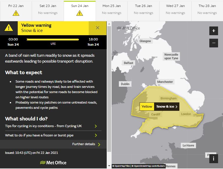
An area of rain will cross the west and southwest of the country on Sunday morning and turn readily to snow as it spreads eastwards, and also lead to some icy surfaces. Mainly 1-3 cm of snow accumulation for most parts, but possibly 5-10 cm over 100 m with a small possibility of 10-15 cm over high ground for example on Dartmoor, the Brecon Beacons and Snowdonia. These snow amounts will cause some disruption to transport, especially on routes that cross even modest high ground.
Source: Met Office warnings
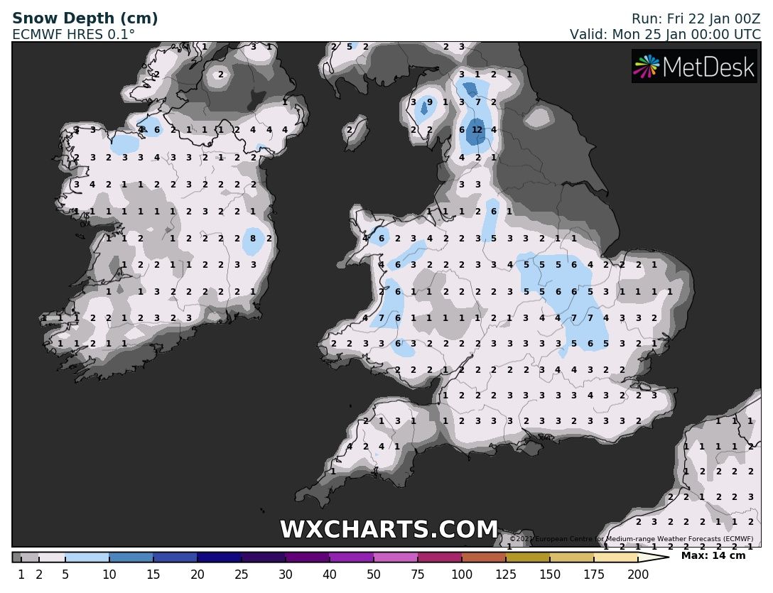
Possible (ECWMF) snow accumulations by the end of Sunday, source: wxcharts.com
Another spell of sleet or snow showers could pass southeast across Wales, Midlands and parts of southern England on Sunday night too. Monday and Tuesday looking drier and more settled though, as a ridge of high pressure builds in, but later on Tuesday rain looks to move in across the west, perhaps preceded by some snow before turning to rain across the north Tuesday night. Thereafter, turning milder but increasingly unsettled, as a succession of Atlantic lows roll on off the Atlantic bringing wind and rain at times.