Temperatures yo-yo next few days, mild today before cold front sweeping rain eastward is followed by cold northerly winds Thursday, then back to mild again Friday onwards.
Temperatures will yo-yo for the rest of the week, as we go from mild today to cold tomorrow then back to mild on Friday. Yesterday the temperature got up to 16.3C in Flintshire, in northeast Wales and strong southerly winds are bringing a mild start this morning, temperatures as high as 14C at dawn in the NE of Scotland. However, a cold front will sweep eastwards today, bringing rain followed by winds turning northerly briefly tomorrow, bringing much colder conditions than of late with wintry showers in the north. Cloudy, windy, wet and turning milder on Friday. The weekend is looking mild and breezy, cloudier with chance of rain or showers in the north, but southern areas are looking mostly dry and brighter.
Next few days will go from mild to cold to mild again
For now, a rather mild start everywhere in a strong southerly wind, areas to the lee of high ground, such as North Devon, north Wales, NW England, parts of eastern and northeastern Scotland already 14C at dawn. The wind gusting to 40-50mph through the Irish Sea, across north Wales and up across southern Scotland. It’s a dry and bright start in the east, but in the west cloudier skies with outbreaks of rain pushing in across far SW of England, Wales, Cumbria, N. Ireland and western Scotland for the morning commute and school run.
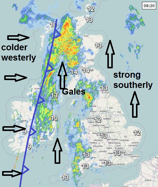
Outbreaks of rain, locally heavy, pushing in across the west this morning will slow spread eastwards through today. So after a dry and bright or sunny morning across the east, it will turn cloudier from the west by early afternoon, with rain arriving from the west through the afternoon, though turning lighter and more patchy as it arrives across eastern England. Brighter but colder conditions following across the west before dusk this afternoon, becoming mostly dry for SW England and Wales, blustery showers for NW England, N. Ireland and western Scotland. Remaining mild across eastern areas this afternoon, temperatures of 12-15C, but following the cold front clearing east, temperatures in the west falling to around 9-11C by mid-afternoon.
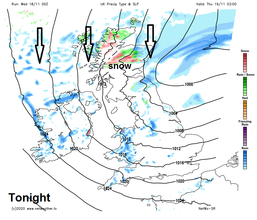
Winds becoming strong as they turn northwesterly then northerly across northern areas tonight, with gales or severe gales developing around coastal fringes of Scotland, N. Ireland, NW England and Wales. The wind will drive showers southwards across northern then central areas through the night. And as much colder air digs south in the north, showers turning wintry over Scotland, with snow over the hills. Southern areas of England and Wales staying mostly dry with clear spells and chillier than recent nights.
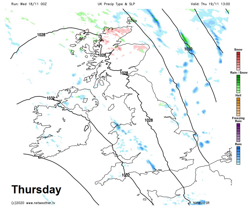
A colder day for all on Thursday, a strong northerly wind in the morning will drive showers southwards, these most frequent along eastern coasts and also Wales, northern and western coasts of N. Ireland. Gales along eastern coasts of Scotland and eastern England. Winds easing through the afternoon as they turn northwesterly, while a ridge of high pressure building from the west will mean showers will also ease and become confined to eastern coasts. Temperatures generally in single figures at best, reaching just 4-7C across Scotland and NE England, further south reaching 8-9C, perhaps 10-11C across south Wales and SW England. Feeling colder than temperatures suggest in the wind.
Turning cloudy and milder from the west Thursday night, with rain arriving across the west. Then a cloudy, windy but milder day on Friday, with outbreaks of rain spreading east across most areas. Rain easing across SW England and Wales in the afternoon, rain perhaps heavy and persistent across western Scotland. Temperatures returning back to double figures for most, reaching 10-13C.
Windy again on Saturday, a band of rain along cold front first thing across southern Scotland and N. Ireland will continue southeastward across England and Wales, cloud and patchy drizzle or light rain to the south. Brighter conditions following the front across the north, with blustery showers for northern and western Scotland. Mild for most, temperatures reaching double figures.
Drier with winds easing for England and Wales on Sunday, once early cloud and patchy rain clears the far south, as ridge of high pressure builds in from the southwest. Scotland and N. Ireland windier with sunshine and showers.