THIS WEEK - Milder air is on the way with a warm Tuesday across the UK, although with rain warnings for western Scotland. A dramatic change by Thursday morning with snow forecast in the north.
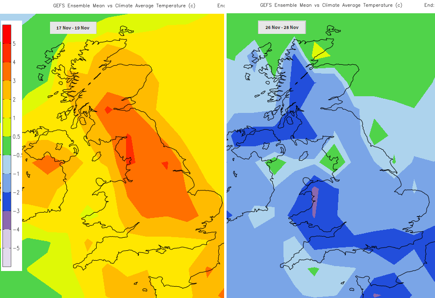
Monday morning and more November low pressures are rattling our way off the Atlantic. Further spells of wind and rain with brighter lulls in-between. A dramatic change in the north by Thursday morning as temperatures plummet from possibly 17C on Tuesday to only 5C for NE Scotland. Those lows are forced further north later in the week with high pressure trying to build from the south. Midweek is briefly colder, but it looks like the end of the month will be colder than average, quite a departure from the mild November we’ve seen so far.
Lively, mobile conditions continue this morning as one low pressure heads away over the Norwegian Sea and another one heads in from the Atlantic, its centre moving between Iceland and NW Scotland tonight.
There are coastal/tidal flooding concerns today, the Thames Barrier is closing this morning as it does occasionally. The Environment Agencies highlight the Yorkshire coast, NW, NE and SE coasts, also Wales and northern Scotland with travel disruption possible.
NE Britain has seen a brighter start this morning with increasing cloud away to the SW and over Ireland. Fresh blustery winds are blowing showers into western Scotland, clipping Northern Ireland and low cloud over Wales and England is giving some damp grey weather. The cloud will break up as the brisk west to SW winds continue, allowing sunshine for central and eastern Britain. Lee wave activity could again give some interesting clouds. Rain moves over Northern Ireland and reaches western Wales and Cornwall early afternoon. As the winds back the rain will reach SW Scotland, more of Wales and SW England by teatime. The increasing cloud to the SW is from a warm front and tonight the UK will be in the warm sector with some milder air. Daytime temperatures will be around 10 to 12 and similar overnight for all but northern Scotland with an early dip. The milder air arrives later in the night with strong SW winds through the Irish Sea and for west coast Scotland.
The day starts off mild, still blustery with more cloud in the west, again grey with dampness but breaks do appear for eastern Britain allowing brighter spells. The waving frontal band lingers away to the NW, so just brushing north coast Northern Ireland and continuously feeding into western Scotland, “a warm conveyor”. This ongoing rain forecast has led to concerns from the Scottish Environment Agency (SEPA) and a yellow rain warning from the Met Office for all of Tuesday into Wednesday. The NW Highlands could see up to 200mm of rain from this event.
“Heavy and prolonged rain is expected through Tuesday and much of Wednesday. Flooding is possible in places along with disruption to travel. “Met Office
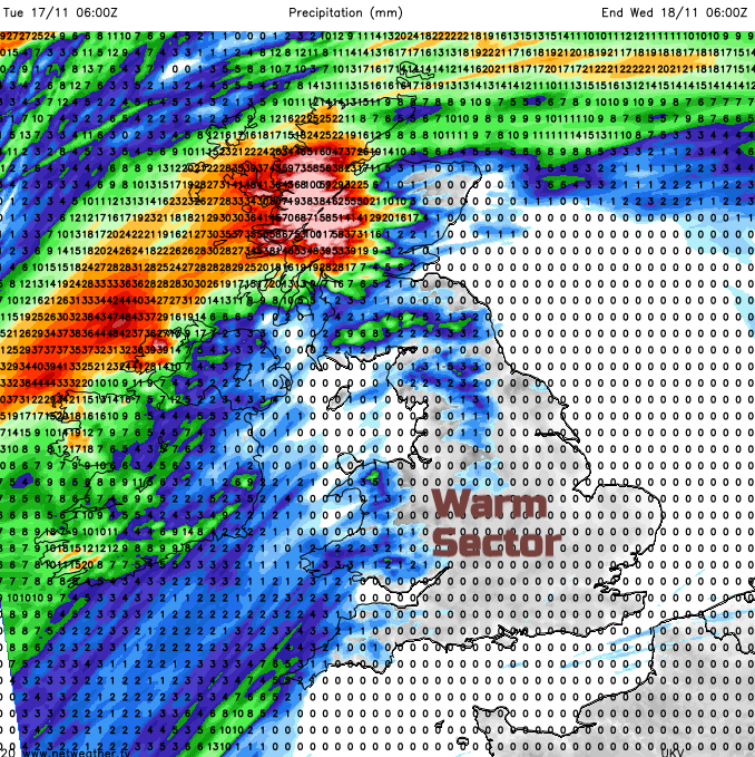
It will be very mild. Temperatures widely of 14 or 15C, to the lee of high ground 16 or 17C is possible in brisk SW winds as brighter skies appear in the warm sector.
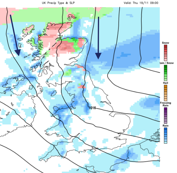
Significant changes come as a vigorous midweek low pressure moves through and colder air follows. The cold front sweeps over Britain on Wednesday, and through Wednesday night a raging northerly takes hold briefly for northern Britain, Northern Ireland and will bring snow showers for Thursday morning with a wintry start the day. Much different from Tuesday’s warmth.
The wet and windy weather early this week coming right across the Atlantic includes remnants of what was hurricane Eta. Another tropical addition is warm air from the south from ex-tropical storm Theta, which was in the region of Madeira at the weekend and has been bringing unsettled weather to the Canary Islands and the Algarve.
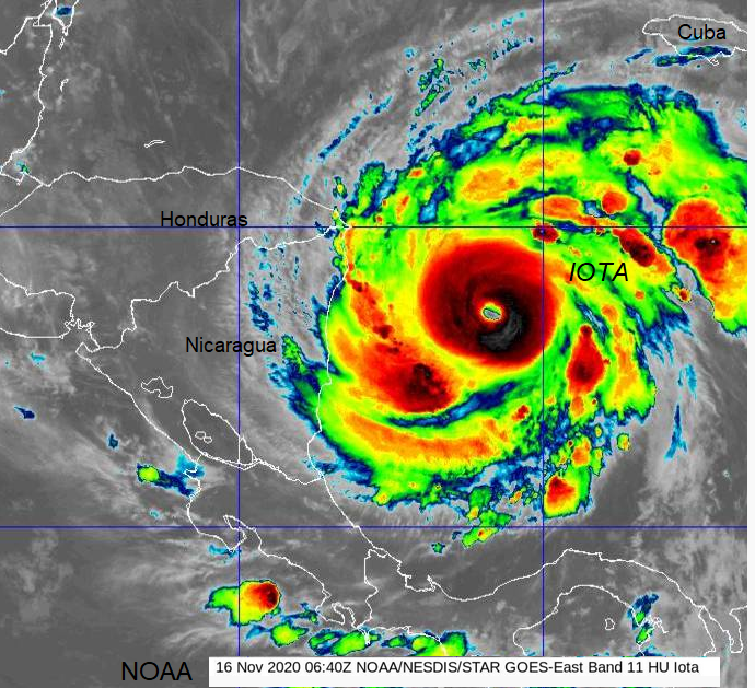
Nicaragua and Honduras prepare for the next major hurricane to hit in less than two weeks. The North Atlantic has not seen two major hurricanes in November before, both heading for Central America. Poverty, pandemic and devastating flooding from Hurricane Eta in early November will now be added to again as Hurricane Iota is forecast to make landfall over NE Nicaragua / eastern Honduras later on Monday 16th, local time. NHC “resulting in significant to potentially catastrophic impacts”