Brighter & mostly dry today and Friday, though chance of showers in the west and rain tonight. Turning rather unsettled & windy over the weekend, with rain at times for all.
All parts have seen a transition to a more unsettled weather pattern through the middle part of this week, kicking off with an active frontal system moving east yesterday bringing a spell of heavy rain and strong winds across all parts by midnight last night. Further weather systems are on the way over the next few days, as a strong jet stream takes aim at the UK, bringing spells of rain and windy at times, but there’ll be some drier weather in between too. Thursday is set to be mostly dry and bright, as a brief ridge of high pressure builds between systems, before rain moves into the west tonight before clearing the east late tomorrow morning, then another dry spell Friday away from the northwest, before a rather wet and windy weekend is in store for many, with gales around coasts.
Unsettled at times over the coming days, particularly over the weekend, as the jet stream cranks up and aims at the UK
For now, after a wet and windy night and a few early showers that will soon clear, a ridge of high pressure building in will ensure a mostly fine and dry day. After a sunny morning for many, once early cloud clears, best of the sunshine becoming confined to the east in the afternoon, while cloud builds in the west and the wind picks up, cloud thick enough to bring a few showers in the west and perhaps more persistent rain across the far west of Scotland. Temperatures ranging between 10-13C.
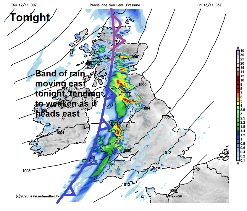
Cloudy skies and windy conditions spreading east across most parts overnight, a band of heavy rain arriving across Ireland and N. Ireland from the west this evening will spread east across most parts during the night, though rain band tending to break up and turn showery. SE England and East Anglia staying mostly dry.
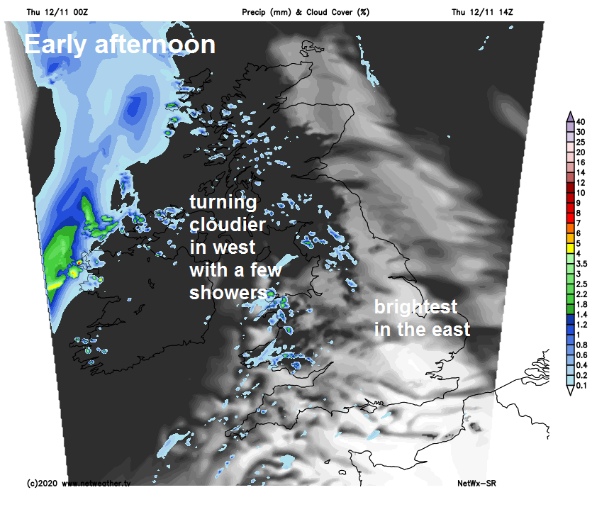
Some patchy rain first thing across SE England and East Anglia clearing away from mid-morning, to join most areas to drier and brighter conditions, with winds easing. There will be some scattered showers in the west, heaviest and most frequent across western Scotland. Temperatures reaching 10-13C.
Low pressure out in the Atlantic will move in closer to the northwest of Britain over the weekend, turning the weather rather unsettled. It will be windy too throughout, with coastal gales. Frontal systems will bring outbreaks of rain, locally heavy, northeast across all areas on Saturday, showers or longer spells of rain on Sunday. Despite often cloudy and wet conditions, it will be quite mild in the strong southwesterly wind – particularly during the first half. Temperatures on Saturday ranging between 12C in Scotland to 16C in southern England, on Sunday a little cooler, reaching 10-14C.
Monday’s looking drier and brighter while becoming less windy, as a brief ridge of high pressure moves in, a few showers in the north but most dry and sunny. Tuesday to Thursday unsettled again, as low pressure moves in closer to the northwest, isobars tighten and frontal systems bring spells of rain or showers, but with some drier and brighter spells too. A ridge of high pressure could build in from the southwest on Friday, settling the weather down and turning drier and less windy.