The weather hasn't been able to make up its mind of late, it's been mostly settled and quiet but with some, at times, heavy rain putting in the odd appearance since late last week. Now though, the direction of travel is much more clear - it's going to turn much more unsettled as low pressures queue up to move in from the Atlantic.
The weather hasn't been able to make up its mind of late, it's been mostly settled and quiet but with some, at times, heavy rain putting in the odd appearance since late last week. Now though, the direction of travel is much more clear - it's going to turn much more unsettled as low pressures queue up to move in from the Atlantic.
That change is underway from the today, as a small low moves up from the southwest, close to Ireland. That'll push rain and strong winds in from the west, which will move east to all parts during the rest of the day and overnight.
For much Ireland, Scotland and parts of Northern England, it's going to mean a wet day virtually from start to finish as the rain will struggle to get moving initially. On the flip side of that, away from the western fringes of England and Wales, it's likely to stay dry until well into the afternoon, and in the case of central and eastern regions, it'll be after dark before any meaningful rain turns up. Ahead of the wet weather, it'll still be mild with highs again up into the teens. But behind it, there is some fresher air which will mean a slightly chillier night than we've become used to lately, with lows of 4-7c.
Into Thursday, the rain should clear the east of England in the early hours to leave much of the country dry with sunny spells. There will be a few showers affecting England and Wales though, and the next band of rain won't be too far away - getting into western Ireland and western Scotland during the afternoon. As that arrives, winds will strengthen again with gales likely in exposed parts of the north and west.
All that will move quite speedily from west to east during the latter part of the day and overnight, but the rain will take a little while to clear the southeast and East Anglia on Friday morning. With low pressure sitting between Scotland and Iceland, we'll be left in quite a fresh, blustery flow with frequent showers in the north and west. Further south and east it'll be drier with some sunny spells.
Looking ahead to the weekend, the next low pressure will be closing in from the Atlantic. That'll throw its fronts up over the UK with some heavy downpours possible at times throughout, which may well lead to some flooding issues.
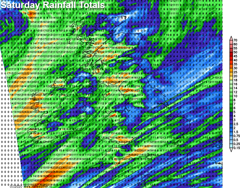
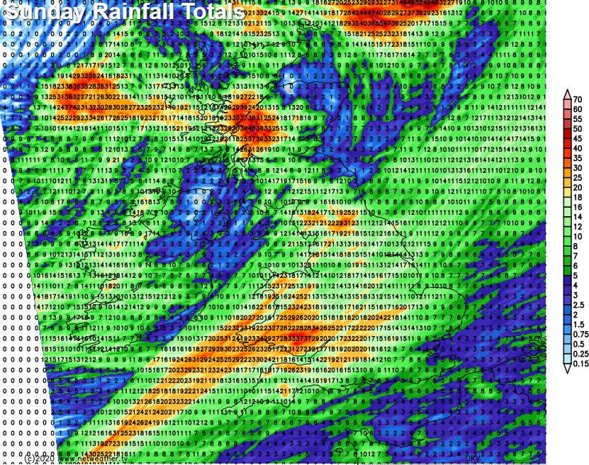
The winds will also be strong and gusty, particularly on Sunday as the low moves closeby. Plenty to keep an eye on during the next few days.