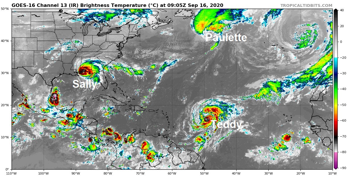
The north Atlantic now has 3 hurricanes on the go, first time since September 2018. And not to feel left out, the Mediterranean has a Medicane brewing that will hit Greece.
While the weather continues to remain rather benign over the coming days for the UK, the Atlantic Hurricane season is in full swing, with three hurricanes on the go as of this morning, with Hurricane Teddy joining Hurricane Sally and Hurricane Paulette.
Closer to home, an area of low pressure over the Ionian Sea, characterised by thunderstorms, has developed tropical characteristics know as a ‘Medicane’ in this part of the world. It has been named Ianos by the National Observatory in Athens and expected to make landfall as a vigorous storm across southern Greece on Friday.
Hurricane Sally is currently the main threat to land, with a threat of catastrophic life-threatening flooding expected along parts of the Gulf coast of the southern US. The hurricane now strengthened to category 2, with 105 mph winds in the northern outerwall and hurricane force winds spreading onshore along the Gulf coast from Alabama to Florida this morning. The eye of Hurricane Sally is close to the Alabama coast this morning, but its slow movement onshore will bring a prolonged period of flooding rains to the this portion of US Gulf coast. Also, a life-threatening storm surge is expected along portions of the Gulf coast from Alabama to the western Florida Panhandle. The hurricane should rapidly weaken later this week, as it moves northeast inland and becomes ex-tropical.
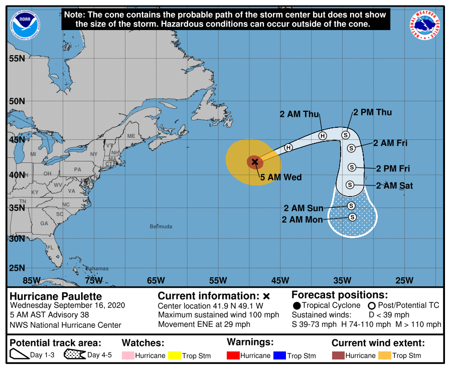
Hurricane Paulette is expected to weaken and lose its tropical characterstics over the next few days, as it moves over cooler waters while encounters strong wind shear and dry air. The storm currently moving northeast southeast of New Foundland will create large swells for the coasts of Canadian Maritimes and NE USA, but as it weakens it will swing south to the west of the Azores.
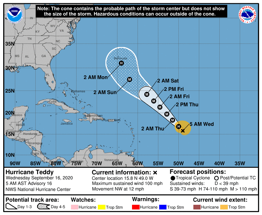
Meanwhile, Teddy rapidly intensified from a Tropical Storm into a Hurricane overnight, now a category 2 Hurricane. Further strengthening is expected and Teddy could become a major Hurricane into Thursday, forecast to become category 4 later this week. Current forecasts track the hurricane northwest over the central and north Atlantic towards Bermuda over the weekend. So Teddy will be watched closely for threats to these islands.
Over to the Mediterranean, an area of low pressure, named #Ionas by the National Observatory in Athens, Greece, is expected to deepen over the Ionian Sea today and tomorrow, before hitting southern Greece with heavy rain and gusty winds on Friday. This storm bears the tropical storm characteristics of a Medicane.
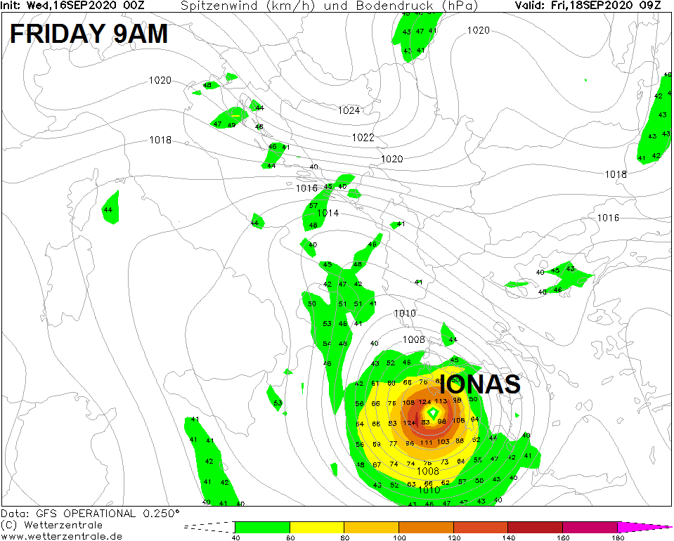
The Mediterranean is not somewhere you immediately associate with tropical storms. But tropical-like cyclones, called Medicanes, feature strong winds that circle around an eye and accompanied by heavy rain do form from autumn through into winter. They form when thunderstorms feed off the warm waters of the Mediterranean, which often reach 27C or more in September and remain warm into the winter, with the area of storms eventually taking on a circulation with tropical storm characteristics with a warm core (as opposed to cold cores of the lows that affect the UK). However, there are differences between Medicanes and normal tropical storms in that the former tend to rely on upper troughs and associated cold air incursions to trigger convection that then goes on to form a storm circulation, whilst the latter do not require this interaction. Although Medicanes rarely reach Hurricane strength, they can sometimes form an eye-like centre and they can bring flash-flooding, strong winds and associated large swells and rough seas to land areas bordering the Mediterranean.