A fair week to come for many with September warmth, rain at times from the west but a nip in the air early Thursday.
A fair week to come for many with September warmth, rain at times from the west but a nip in the air early Thursday.
With the jetstream currently further north, Iceland is once more in the path of all the low pressures for this week, with gale warnings and talk of sleet over its mountains. As the lows pass by to the north of the UK, we see rain from trailing weather fronts but more settled weather in the south as high pressure tries to push our way. It doesn’t quite succeed, so the weather remains a bit mixed although noticeably warmer on Tuesday.
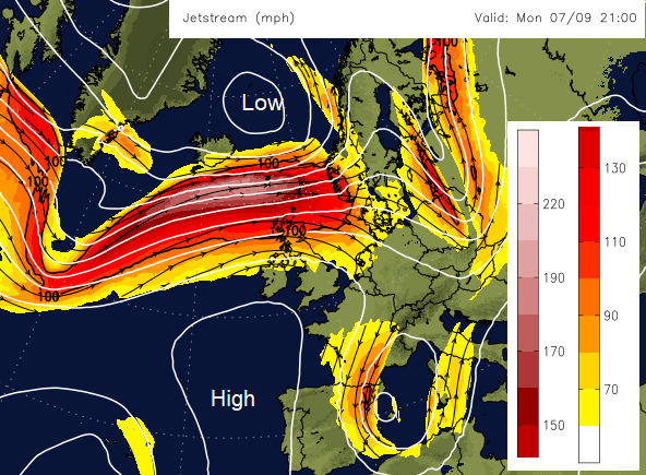
In today’s south-westerly flow there has already been heavy rain over western Scotland and Northern Ireland, and this has moved down to eastern England and more is edging into north Wales. More rain is appearing in the far NW but much of southern Britain is fair and dry and Grampian is also fine. The exposed parts of NW Britain and Northern Ireland will see further cloud and rain today as series of fronts head SE. Other parts of Britain will see a good deal of cloud with bright or sunny spells today, more likely in the east or southeast. Aberdeen could reach 22C with eastern Britain fairing well, into the low 20sC. Overall temperatures remain in the teens with a SW to west breeze, very light for southern England and fresh in the north.
Overnight the frontal band, the cold front will have settled midway down Britain and then it starts to wave. To the north it will be clear and cool, just dipping into single figures inland. Under the frontal band more cloud and a little patchy rain or dampness. To the south still mid-teens, broken cloud but damp for SW Britain.
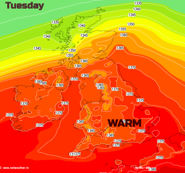
A plume of warmer air which was drawn in on Monday will be over the southern half of the UK on Tuesday and SE Britain could see temperatures in the mid 20SC, so warmer than it has been lately.
For many Tuesday will be a fine day. This waving front will bring more cloud and outbreaks of rain in from the west at some stage but often with waving fronts the timing and location of rain can vary from the forecast, a bit further north or south, earlier etc. So do bear that in mind for Tuesday pm.
Another cold front should work its way SE over Britain during Tuesday night (currently showing heavy rain over Scottish hills) and Wednesday it fades as it works its way southwards over England and Wales. Clear skies and fresher air follow but SE Britain will still manage another warm day. It will be blustery further north. Gardeners take note, Wednesday night will be noticeably cooler but with more fine weather for Thursday, just a few showers from the NW and then more rain for NW Scotland by Friday.
Even with a wet week for western Scotland, it may not help the areas on moderate water scarcity, this links back to dry conditions last winter in the far NE. Although Northern Ireland and western Britain will see more cloud and damp conditions at times, there will be pleasant September weather in a time of seasonal transition. When you realise that summer and the daylight are fading so any fine, warm days seem like quite a bonus, before we head into the wilds of autumn and darker times of winter. It seems hard to remember last winter after the long weeks and months of lockdown.