The weather remains rather mixed and Atlantic driven with a scattering of showers, but at least there's a fair amount of scope for those who need to work or wish to venture outside in the sunny spells there'll be on offer.
The weather remains rather mixed and Atlantic driven with a scattering of showers, but at least there's a fair amount of scope for those who need to work or wish to venture outside in the sunny spells there'll be on offer. The coming week brings much of the same, with a mix of some rain or showers especially in the North where it'll be windy at times, while the South tends to be less windy and somewhat warmer, with fewer showers.
We have a mixture of cloud and sunny spells across the country this morning, with a kit of showers across Dumfries moving into northern England. It'll be England and Wales in fact that see the bulk of the showers today, some becoming heavy across central and southern parts by the afternoon. Such is the case with showers is that not everywhere will see them, with most parts seeing at least some sunshine, although cloud amounts will vary.
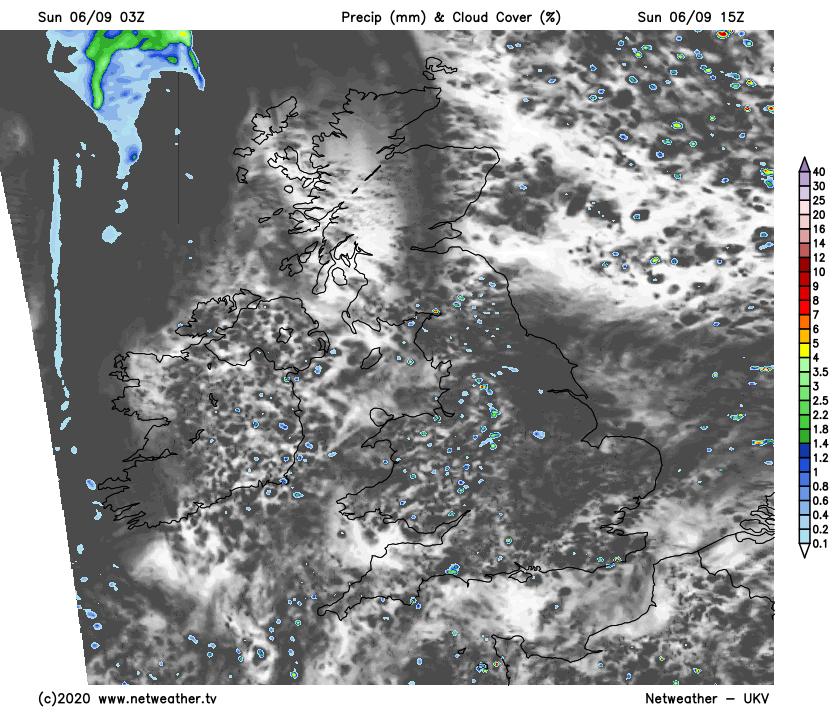
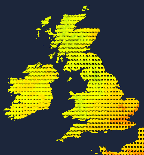
Across Scotland and Northern Ireland there'll be fewer showers and more in the way of sunny spells, with a better chance therefore of it staying dry. Over Northern Ireland however, cloud will be increasing from the West through the afternoon bringing some rain, mostly to Tyrone and Fermanagh. There'll be a mainly light or moderate Westerly wind, that'll become South or South Westerly across Northern Ireland later. Top temperatures just 12 to 15C in the North and 16 to 18C locally 19C further South.
The showers across England and Wales fade into the evening, leaving a dry night with clear spells. Light winds allow it to turn a little chilly in the East before cloud begins to increase in the West towards morning. The East of Scotland should also be dry for a while, before a freshening South to South West wind brings cloud and some rain already over Northern Ireland to most parts of Scotland before dawn. Minimum temperatures 10 to 12C in the West and 7 to 9C in the East.
Eastern and some central parts start the new working week fine, but cloud will slowly increase from the West. But for much of East Anglia, the South East and the South it'll stay dry despite more cloud later. In the West and over Scotland and Northern Ireland it'll be wet with the rain heavy in places, that may turn showery across Northern Ireland and the North and West of Scotland later. A South to South West wind will become strong to gale force in the far North and West with top temperatures 14 to 16C in the rain, 18 to 20C elsewhere, with 21 or locally 22C possible in the South.
England, Wales and much of Northern Ireland should have an overcast evening and night with further rain at times, but much of it will probably be light and patchy across the South. It'll be a mild night though in a moderate or fresh South-West wind, with temperatures unlikely to fall below 11 to 14C. Further North across Scotland, the rain should clear to leave just scattered showers with the wind decreasing a little. Less mild here though, with lowest temperatures in the range 7 to 10C.