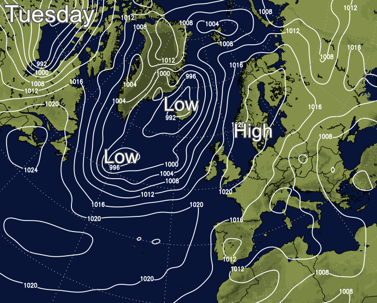
Welcome to meteorological Autumn. Tuesday keeps the quiet and mostly dry weather coming, but with low pressure playing more of a role from midweek, there'll be rain about.
So, that's it for meteorological summer. It ended on a quiet, note and Autumn will begin similarly, but a familiar change to less settled weather is on the way this week.
Today, much of the country will stay dry and bright with some sunny spells. But there will be some patchy, showery rain clearing through Ireland and making its way into western Scotland and the far northwest of England through the day. That's thanks to a weakening weather front associated with low pressure near to Iceland, giving an idea of the shape of things to come midweek, as high pressure is ushered away from the UK.
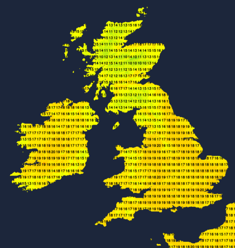
Winds will be blowing from a southerly direction today though, which is going to mean a slightly warmer day than we've seen during the weekend, with the high-teens or low twenties likely quite widely.
Into Wednesday, the fronts from the next Atlantic low arrive onto the scene, and these ones are going to be a bit more lively than Tuesday weak one. The rain is going to spread west to east through the day, but it's likely to be quite erratic progress, with some of the rain turning showery. There will be some heavy downpours in amongst it all, and it should get through to affect much of the country before the day is out. Central and eastern parts should stay dry for a good part of the day though, with some bright or sunny spells.
Behind that, another front will bring rain overnight and into Thursday, this time moving down from the northwest and introducing clearer, fresher weather with sunshine and blustery showers in behind it. The rain on the front will be heavy at times again as it moves southeast but will tend to weaken and break up as it moves into central and southern England. It's also quite likely to get stuck or at least slow right down, with patchy rain and a fair bit of cloud liable to hang around over southern England through into Friday.
For the rest of the country, the week ends on a fresh note with sunshine and showers. It'll be breezy too, if not blustery in the far north and west, with a lot of the showers confined to the north and west as well. Temperatures won't be too dissimilar to what we've been seeing during the long weekend, typically reaching up into the mid-high teens. Despite the extra cloud and bits and pieces of rain in the south, it may be a touch warmer here, with maxes touching into the low twenties.
Looking further ahead, high pressure is then set to start to try and ridge over the country from the southwest, but may take a day or so to start to exert its influence.