Another unsettled day today, with low pressure very nearby. But the long, bank holiday weekend will see steady improvement as high pressure edges in.
Not the best of weather I'm afraid as we head towards the start of the Bank Holiday, as currently a complex depression giving rain is followed by blustery cool North winds bringing showers. Conditions will steadily improve over the weekend though, with Monday best, but don't expect a heatwave, with some very chilly nights.
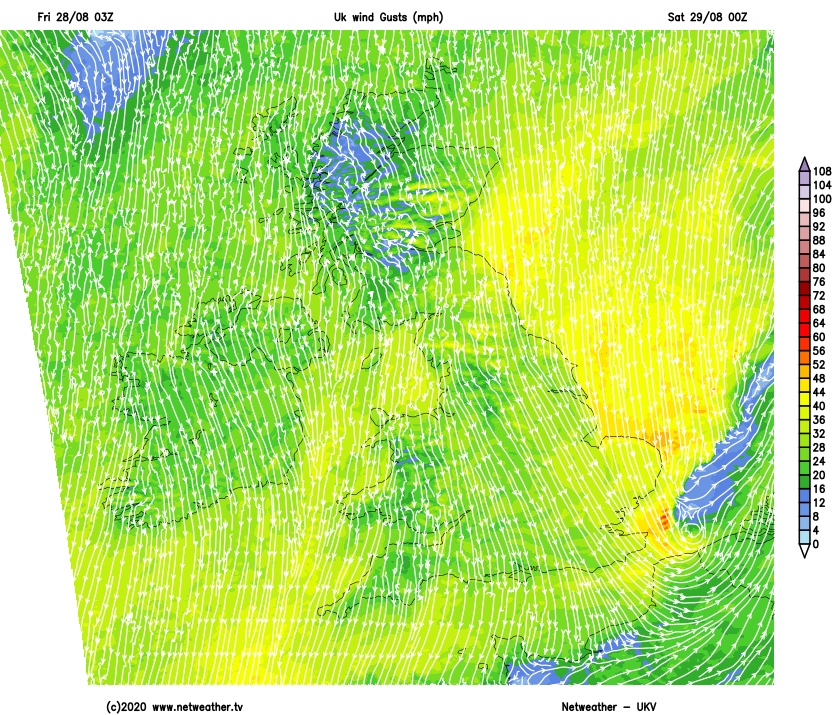
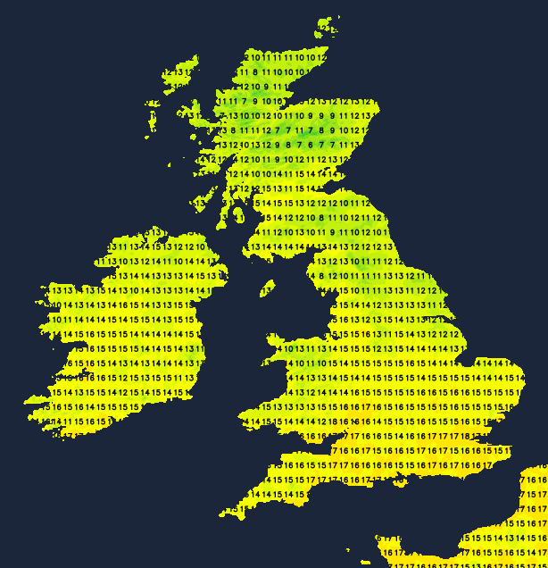
In a very unsettled day, it's a wet start over a swathe of northern England, where rain will be heavy in places and persistent for a while before turning to showers. Much of Northern Ireland is also wet, but this'll clear to sunny spells and just a few showers. It'll also be very cool for late August in a North to North East wind, that'll freshen through the day giving gale-force gusts along North Sea coasts where temperatures get no higher than 13 or 14C.
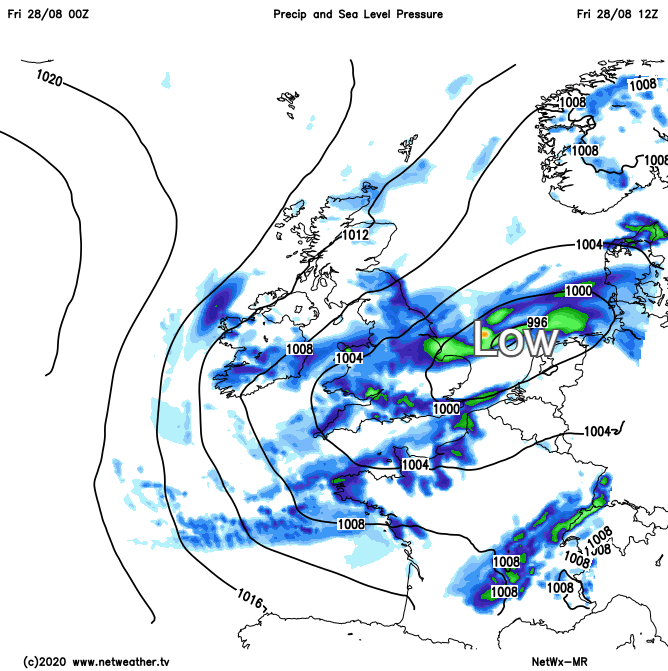
Further South it's really mixed where we have showers and a lot of cloud, but with some sunshine that'll only serve to 'trigger' locally heavy downpours and a few thunderstorms. These will give gusty winds, with North Wales, much of the Midlands and Lincolnshire seeing the showers becoming lengthy later, where early mist and patchy fog will soon clear. It'll be milder in the South though with maximum temperatures 17 to 19C. Once the rain has cleared from the Borders, much of Scotland will see some sunshine, with just a scattering of showers these mostly in the North and East. It'll be chilly though in a moderate or fresh North wind, with top temperatures only 12 to 15C.
Chilly North winds remain blustery into the evening and overnight especially in the East, with gale-force gusts still likely for a while along some North Sea coasts. There'll be more showers particularly over East Anglia and the South East, with fewer showers and clearer skies further West. Across the Northern Isles, much of Scotland and Northern Ireland where winds will be lighter it'll turn quite chilly. A few sheltered Highland glens could fall as low as 3 or 4C, but 6 to 8C in the North and 9 or 10C in the South will be a more general minimum.
Saturday sees sunny spells especially across Northern Ireland, Scotland, Wales and in the West, where apart from a few light showers it'll be dry. It'll feel chilly though in a North West or northerly breeze, with top temperatures only 12 to 15C in the North and 16 to 18C further South. In eastern areas, you'll continue to see scattered showers, with a few heavier ones giving local hail. A fresh, cold and blustery North wind will be most felt along North Sea coasts where temperatures will struggle to reach 13 or 14C.
Eastern areas continue to see a few showers into the evening, before they become confined to coasts of Norfolk and the South East exposed to a northerly wind that should have decreased by morning. Despite feeling cold though, temperatures here shouldn't fall below 7 or 8C. Elsewhere with clearing skies and lighter winds, it'll be a different story, in a particularly cold night for late August. The thermometer could fall close to freezing in some rural Highland glens, with other sheltered vulnerable 'hollows' of the North West also perhaps seeing a ground frost by morning, when temperatures will mostly be in the range 3 to 8C.