Another day, another Thunderstorm warning. Not the heat of last week but still feeling clammy. Heavy rain with the risk of flooding before an Atlantic low brings windy weather later this week.
More heavy rain, thunderstorms and fog in the forecast for Monday. It’s still warm and humid but not the heat of last week. The heavy downpours again bring the risk of flooding as was seen on Sunday in Northamptonshire and Cambridgeshire with a waterspout reported off the coast of Portishead showing severe convection.
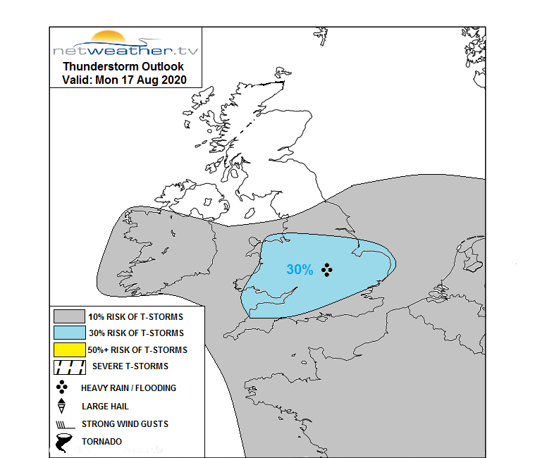
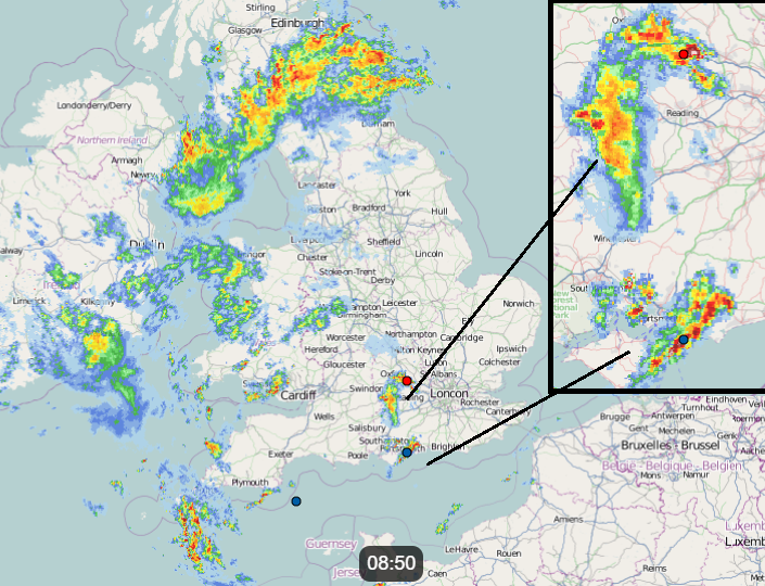
This airmass is warm and moist, hence the mist and murk. This will clear to sunshine and then the warmth will add into the thunderstorm mixing bowl. Today’s storms aren’t forecast to be as severe as they were yesterday but if a different location catches one after a dry day on Sunday then it will grab attention there. There will be more chance of seeing a heavy shower. The thunderstorm warning is over England and Wales today with a scattering of heavy showers already active and a frontal band of heavy rain over northern England just into southern Scotland with thunderstorms off the coast of Northumberland. More storms will develop today, again they will be slow-moving. With up to 75mm in a few hours of rain forecast the risk of flooding remains with lightning hail and gusty winds. As always with showers, other areas will miss these and stay dry.
“…instability will support development of widespread scattered heavy showers and thunderstorms drifting north across much of England and Wales away from the far north of England.” Convective forecast
The frontal band edges NW bringing rain over more of southern Scotland and the Central Belt, into Northern Ireland as another front reaches western Wales and SW England with rain and low cloud. It will be grey and wet. To the north of this, in Scotland, there will be some brightness, even sunshine in the west but low cloud continues to lap in from the North Sea so more greyness here too. Northern England keeps a lot of cloud once the rain band has moved northwards. The rest of England and Wales becomes peppered with showers and the thunderstorms break out again. Temperatures will generally be in the high teens to low twenties although in any longer sunny spells they could reach 25 or 26C around London or East Anglia. Western Scotland will feel warm today.
By Tuesday there will be a lot of cloud and wet weather about for northern Britain and Northern Ireland with a low pressure nearby. Again, over the southern half of the UK, showers break out with sunny spells. The risk of heavy showers or thunderstorms remains across Britain. There will also be thick low cloud and murk giving a gloomy day for some. Temperatures gain high teens to low twenties but with a SW breeze for England and Wales.
We’ve had a week of thunderstorm warnings, slow-moving storms bringing torrential downpours and so flash flooding with lightning, sometimes hail. The winds have been light and so the storms crept along dumping high rainfall totals in one place, flooding roads or car parks. The second half of the week brings a change with gales being mentioned.
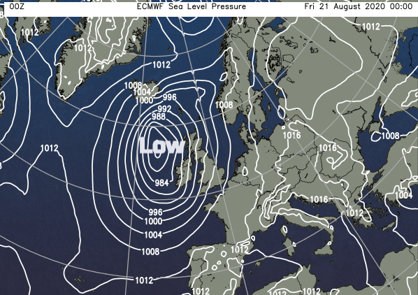
As our weather changes, the Atlantic will have more influence with a large area of low pressure heading in. This contains the remnants of Tropical Storm Kyle. After a brief lull on Tuesday night. This throws rain up from the SW on Wednesday into early Thursday moving right up through the UK with wet and windy weather on Friday. Will be more like autumn although still warm in the east and feeling fresher further west.