


The heatwave is over but the thunderstorm risk continues. For Southern England on Friday and more of England and Wales at the weekend.
The extreme heat is fading but still very warm with the risk of thunderstorms for southern Britain today and later in the weekend. 29.8c in Porthmadog, Gwynedd yesterday, 29.6c in Essex ending the week-long spell of 30c+. This very hot run saw six days of 34C or over, and three days of 35c+ which doesn’t happen very often.
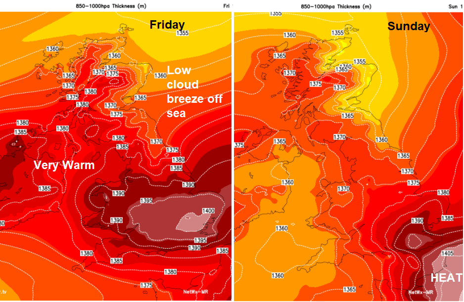
It won't be as hot in the coming days, so if it has all been too much, we've passed the peak of this remarkable event.
“Further heavy showers and thunderstorms are expected today for southern Britain and may lead to flooding again with the risk of travel disruption”
There is a lot of cloud about this morning, with SW Scotland, the Isle of Man and NW England seeing the best of the morning sunshine. Norfolk has already had thunder and lightning from one slow-moving line edging near to Norwich. So, for many, it will be a grey murky start, which improves in the west then inland but with a NE flow off the North Sea, the coasts of NE Britain will keep a cool, grey day. For the rest of the UK, it will be a warm, humid day, feeling very warm for north Midlands, into NW England and western Scotland. Temperatures for much of England and Wales will be in the 20sC. London, East Anglia, the Midlands could see 29C today. So still warm but not the heat of midweek. Most places will have very light winds. Just Yorkshire and Lincolnshire pick up more of a brisk NE breeze off the North Sea.
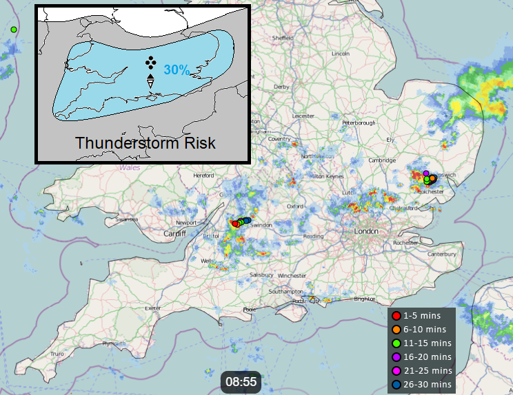
The Severe Convection forecast for Friday has more technical detail about today's thunderstorm risk. There is a yellow warning from the Met Office for Thunderstorms once more for today and Saturday morning. Again, this is a warning area for risk of storms, heavy rain, flash flooding, hail and gusty winds but hit and miss within the zone. Yesterday there was disruption from flooding in Surrey and along the M25 as slow-moving storms headed to London. Today’s storms shouldn’t be as severe but there still could be slow-moving, heavy rain, adding to the standing water from previous days or just hitting new places with very dry hard ground so Friday traffic could experience flooded routes.
Southern England looks most at risk today and tomorrow adding south & mid Wales in for Saturday, for heavy showers and thunderstorms. Northern Britain manages drier weather although with the low cloud in the east and sunshine for the west and fine weather for Northern Ireland during Friday and Saturday. Heavy showers and isolated storms along convergence zones could continue overnight across S Midlands and southwest England.
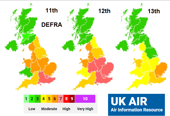
There has been high or moderate air pollution recorded this week as the heatwave conditions continued. Ozone a particular issue. Finally, those levels will come down, starting today.
“Generally Low levels of air pollution are forecast across the UK on Friday. However, there will be isolated areas of Moderate air pollution across parts of west Wales, southwest and southeast England.” DEFRA
Sunday sees the thunderstorm risk returning for England and Wales which lasts into Monday as the showers spread further north. The temperatures stay in the 20sC but the oppressive tropical nights have passed for now. Further into next week, it looks like an Atlantic low will head our way, quite a novel change. This will push warmer air up ahead of it but could bring a spell of unsettled weather across the UK, with wind and frontal rain. Our UK summer weather likes to keep us on our toes.


