Here we go then, after a week of talking about the heat, it arrives today. 35-37c is likely in the southeast today, with highs peaking well into the mid-thirties each day through the weekend and right into next week.
Here we go then, after a week of talking about the heat, it arrives today. 35-37c is likely in the southeast today, with highs peaking well into the mid-thirties each day through the weekend and right into next week.
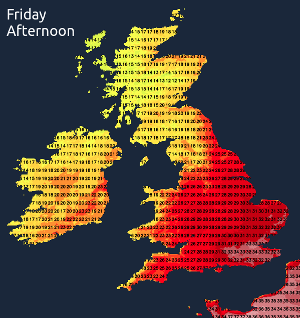
Not everyone will see that level of heat, with the highest temperatures reserved for those in the south and southeast. Still, even so, many other parts will be very warm or hot, but it will cool off with temperatures nearer to average the further northwest you are.
The hot weather won't come without complications. High pressure will be a strong influence on our weather throughout, so there'll be plenty of sunshine on offer. But the high won't be directly overhead, with lower pressure not too far away over the continent. That'll allow the atmosphere to de-stabilise at times, with cloud often bubbling during the heat of the day, allowing for some sharp showers and thunderstorms to develop. Initially, as we end this week and move through the weekend they're likely to be isolated and infrequent, but as we move into next week, the risk will increase.
Today, we have some rain affecting parts of Ireland and Western Scotland, which will come and go through the day, with some of it moving further east into other parts of Northern Scotland later on. Elsewhere, there'll be plenty of sunshine to start, but the cloud will tend to bubble up, with just the odd shower possible in central and southern regions of England.
Saturday will begin dry, with sunshine for most - although there will be some mist and fog in some southern and western parts which will take a little while to clear back to the coasts. The cloud will increase again during the day though, especially in the south, with maybe just the odd shower breaking out in southern and eastern England. Even so, it'll be another very warm, if not very hot day for much of England and Wales with highs into the mid-high twenties widely, low-mid thirties in the south. For Scotland and the island of Ireland, it'll not be quite so warm, with temperatures into the high-teens or low-twenties.
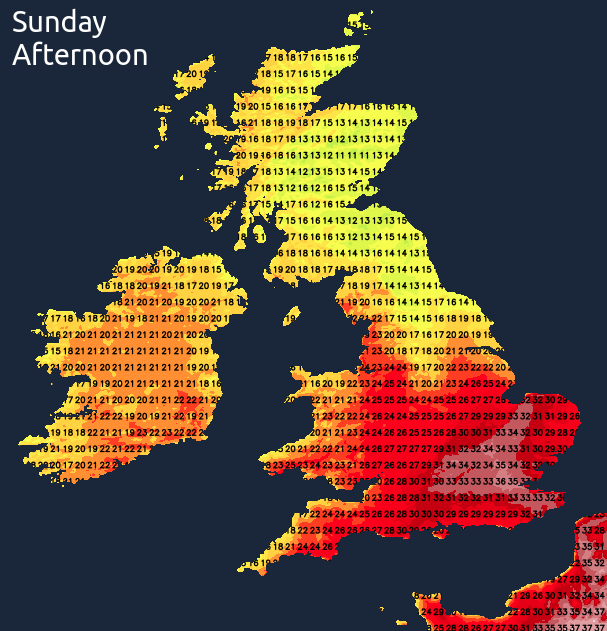
Sunday then brings more hot sunshine to the south of the country. Further north, there'll be a bit more cloud drifting up through northern England and into Scotland - particularly up through central and eastern parts which will keep a lid on temperatures. The cloud is also likely to bring some isolated downpours and storms with it - these perhaps starting the day further south before they move north and allow the sun to breakthrough behind them.
Into the early part of next week, the pattern continues with yet more heat and sunshine, but with a growing risk of downpours and thunderstorms. Not everyone will catch one, but where they do develop they're liable to be lively with plenty of energy in the atmosphere to tap into. Torrential rain, frequent lightning, hail and gusting winds are all possible - so it'll certainly be something to keep an eye on, especially if you're out and about or camping.