A brief taste of summer heat to end July is on the cards for the south, with 32C possible in the southeast on Friday. The first time 30C has been reached this month.
A brief taste of summer heat to end July is on the cards for the south, with 32C possible in the southeast on Friday. The first time 30C has been reached this month. But for now, it will be a cool day for most in a brisk northwesterly breeze, with sunny spells and a few showers – these mainly across the north. A ridge of high pressure will build in on Tuesday, bringing a mostly dry day with sunny spells, though rain will spread across Ireland and later far west of Britain, before pushing northeast across Scotland and far NW of England on Thursday. Meanwhile, high pressure will build across England and Wales, bringing dry and sunny conditions on Thursday and Friday. And with winds turning southerly, temperatures will be on the rise too, peaking on Friday. Cooling off over the weekend, as fresher conditions spread in from the Atlantic.
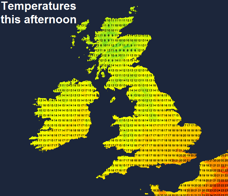
For now, a breezy morning, bright for most, occasional sunny spells and variable amounts of cloud, cloud amounts greatest across the west and bringing scattered showers across western areas and the north of Scotland. The brisk northwesterly wind will continue to blow in showers across northern and western areas through the afternoon, with sunny spells in between, but for southern and eastern areas of England should stay dry with the best of the sunshine. Thicker cloud and more general rain will affect the northeast of Scotland wrapping around low pressure between Scotland and Norway, very wind here too, with gales around coasts. Temperatures a little below average for late July, reaching 17-20C across England and Wales, 13-16C across Scotland and N. Ireland.
Winds easing overnight and showers fading for most, leaving a cool but mostly dry night with clear spells. However, still windy across NE Scotland, with further showers across the north of Scotland. Temperatures falling to around 9-11C.
Low pressure close to the northeast today will move away east across Scandinavia on Wednesday, allowing high pressure to build in, bringing a mostly dry and bright or sunny day and with lighter winds it will be a couple of degrees warmer than today, reaching 15-18C in the north, 18-23C in the south. However, a few showers are still possible across the far north of Scotland, while cloud will thicken across the west in the afternoon, as a frontal system pushes in across Ireland ahead of low pressure over the Atlantic bringing thicker rain to Ireland and eventually Irish Sea coasts of Wales and NW England by evening.
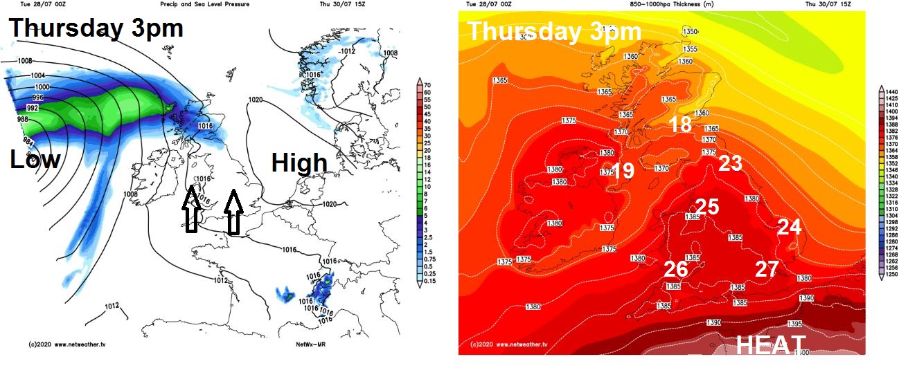
Further outbreaks of rain pushing NE across Ireland and N. Ireland Wednesday night, reaching SW Scotland by dawn on Thursday before continue to spread northeast across Scotland during the morning, followed by dry and brighter and drier conditions across southern Scotland in the afternoon. Much of England and Wales dry and with increasing amounts of sunshine from the south after perhaps a cloudy start in the north and west. Best of the sunshine across south Wales and southern England – where we could reach 26-27C, elsewhere temperature reaching high teens or low twenties.
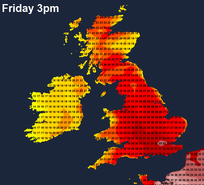
Hotter on Friday, as we draw in southeasterly flow off a hot near continent and with sunshine for many temperatures will reach the mid-to-high twenties widely, reaching 25C in Glasgow, 28C in Cardiff and Manchester, 30C in Birmingham, perhaps 32C in London. It will be cooler across the far west, with cloudier skies and thundery showers spreading north across Ireland and N. Ireland, these perhaps affecting Irish Sea coasts of Wales, Isle of Man and west of Scotland by evening. A small risk of thundery showers breaking out in the southeast in the evening too.
A cold front sweeping east Friday night will sweep Friday’s heat away and introduce cooler and fresher conditions for all on Saturday. The westerly breeze will bring sunny spells and variable amounts of cloud which will be thick enough at times to bring some scattered mainly light showers, especially across the west. Similar day on Sunday, fresh westerly breeze bringing sunny spells and scattered showers, mostly across the west, perhaps heavy across the northwest.