After a lively start to the weekend, today (Sunday) will be quieter but still with a scattering of sharp showers. Next week starts unsettled with low pressure in charge, but high pressure builds midweek with some very warm air arriving later in the week.
It was a lively start to the weekend yesterday (Saturday). Just about all parts got wet, with many areas seeing heavy, if not torrential downpours, which for some brought over an inch (25mm) of rain. On top of the rain, there were thunderstorms and even a tornado or two. Including this one in Northampton:
The end of the weekend isn't going to be quite so action-packed though, with a day of sunny spells and scattered showers. Further ahead, next week will be a week of two halves. The first half will keep low pressure in charge, so expect more showers or longer spells to move through at times. High pressure will build in from the southwest from Wednesday onwards though, settling things down with some very warm air arriving by the end of the week too. You'll probably not have a lot of time to get used to the settled and sunny weather though, as a (potentially thundery) breakdown is likely to arrive from the west for the weekend.
Back to today, the showers will be most frequent in the west and north of the country, whereas further east they'll be fewer and further between with some locations southeast managing to miss them entirely. With low pressure anchored to the northwest of the British Isles, it'll be a breezy if not blustery day with winds blowing in from the west or southwest. Temperatures will be warmest in southern, central and eastern regions with highs of 19-22c, further west 15-19c will be more like it.
Later in the day, a new Atlantic system will start to show it's hand, with a spell of rain moving in from the southwest. That will spread northeast overnight and into Monday, with sunny spells and some sharp showers following behind the main band of rain. The low responsible for all of this will also cross the country during Monday, with some blustery winds circulating around it before it finally clears away into the North Sea on Tuesday.
Tuesday then brings a day of sunny spells and scattered showers, with many of those showers in the north and east of the country - the areas which are nearest to that low pressure. Then, midweek sees the change arrive with high pressure starting to build. There may be one or two showers leftover on Wednesday, for a time at least. But in the main, it'll be a dry day with sunny spells. It won't be especially warm at this point though, with perhaps just the southeast corner seeing temperatures rise into the low-twenties.
As the high slips further east on Thursday, it'll allow southerly winds to develop, bringing much warmer air north with them. That'll see maxes rising into the low-mid twenties widely, but with that high slipping east it will open up the door to the potential for some showery rain in the northwest.
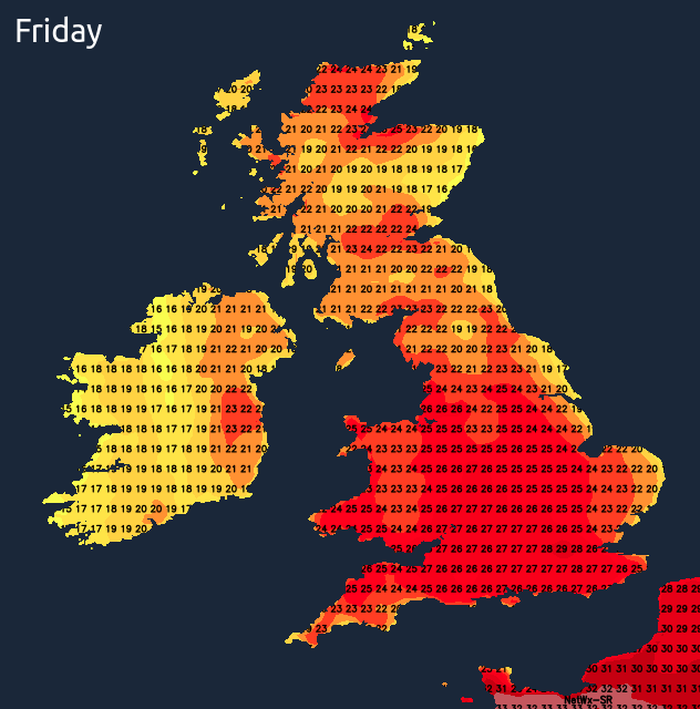
Friday is a way off but looks likely to be the peak of the heat with temperatures by this point reaching the high-twenties perhaps even low-thirties. If we do make 30c, it'll be for the first time in July 2020, on the final day of the month.