A cold front bringing somewhat cooler, fresher weather, steadily works its way from the North West through today and tomorrow, before finally clearing the Kent coast on Sunday.
A cold front bringing somewhat cooler, fresher weather, steadily works its way from the North West through today and tomorrow, before finally clearing the Kent coast on Sunday. This'll give showery mostly light rain, with small waves running along the front occasionally enhancing the rainfall mainly in the West.
The front is currently giving some rain over Northern Ireland and Scotland, this spreading to parts of northern England and the Isle of Man later. Behind the front, it turns somewhat cooler and fresher, with the North of Scotland clearing to a mix of sunny spells and scattered blustery showers. Central Scotland and parts of Northern Ireland may also brighten up later in a West or South-West wind that'll be fresh towards Highland. Top temperatures 14 to 17C, with 18C possible towards The Borders.
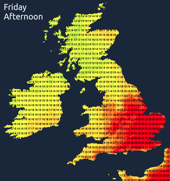
Across England and Wales there'll be variable amounts of cloud, but with more in the way of sunshine on the whole than yesterday. It'll be dry, and after a humid night, it becomes very warm, with top temperatures 22 to 25C fairly generally and 26 to 27C over parts of the East and South in a light or moderate West or South Westerly breeze.
Our cold front giving patchy light rain with a few heavier bursts will be lying across northern England and the North and West of Wales during the evening and overnight. To the South of it, it'll be a summery evening although cloud amounts will vary followed by a humid night. Apart from a little drizzle in the West, it'll stay dry in a West or South Westerly breeze, with temperatures falling no lower than 14 to 16C.
Over Scotland and Northern Ireland it'll be cooler and fresher, with the North and West continuing to see scattered showers. Patchy rain should eventually clear from Lothian and The Borders leaving clear spells. With a South West wind light over Fife and the Central Lowlands, a few mist patches may form in rural valleys briefly around dawn. Lowest temperatures across Scotland and Northern Ireland 9 to 11C.
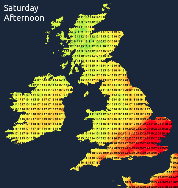
The front should be straddling Wales and central parts on Saturday giving cloud and mostly light rain, with perhaps the odd heavier burst. To the North of the front over Scotland, Northern Ireland and the far North of England, it'll be a day of sunny spells and scattered showers, these mainly in the North and West where some will be heavy. Top temperatures in the North 13 to 17C in a moderate of fresh South-West wind.
In the South, it continues humid, but with a lot of cloud. This should break at times though to give some sunshine mostly towards the South East, making it very warm here again. Most places stay dry, although the Midlands and Lincolnshire may see a few showers. Winds mostly light South Westerly, with top temperatures 19 to 23C but 24 perhaps 25C across London and towards Sussex and Kent.
The far South-East may see a summery evening, but much of the South see cloud and patchy rain after dark. Elsewhere there'll be clearing skies, with just a few showers in the North and West. Lowest temperatures 8 to 12C in mostly light Westerly breeze, with the South turning somewhat cooler and fresher towards morning.