Unseasonably windy and cloudy with rain at times over the weekend, particularly wet in the north, though feeling humid for a time Saturday. Drier weather in the south next week, but the north staying unsettled.
It hasn’t exactly felt like summer through the week, with windy conditions, spells of rain or showers and temperatures in the high teens or just into the low twenties Celsius at best. This in stark contrast to last week, when we saw temperatures reach the 30s Celsius quite widely across the UK. Today and the weekend continue the not particularly summer-like theme, with most parts becoming rather cloudy at times, with rain or showers, particularly across the north and west. It will become unseasonably windy through the weekend too as the isobars tighten with areas of low pressure crossing the north. The driest, brightest and warmest conditions likely to be found towards the southeast of England. However, it looks to turn drier across southern areas next week, as a ridge of high pressure builds in, but the north will continue to see cloud, rain and windy conditions at times and nowhere will be particularly that warm.
For now, Friday will have more of an autumnal feel rather than high summer feel across northern and western areas, with wet and windy conditions through much of the day, though southern England and East Anglia should remain mostly dry and bright or sunny until this evening.
So cloudy and windy with outbreaks of rain for much of the day across northern, central and western areas and while Wales, SW England and the Midlands will be drier for a time, it will turn wet here through the afternoon too. The rain turning heavy and prolonged, with a couple of inches falling over western hills, the Met Office have issued a yellow warning for rain for SW Scotland – where 20-30mm could fall quite widely, locally as high as 60mm over higher ground.
It will turn very windy too, with gales developing across Irish Sea coasts, North Wales and northern England in particular. So, it won’t feel particularly pleasant. After a sunny and dry start across southern counties England and East Anglia, clouding over as we head through the afternoon, with a few spots of rain for East Anglia and central southern England, sunshine perhaps hanging on across the far southeast.
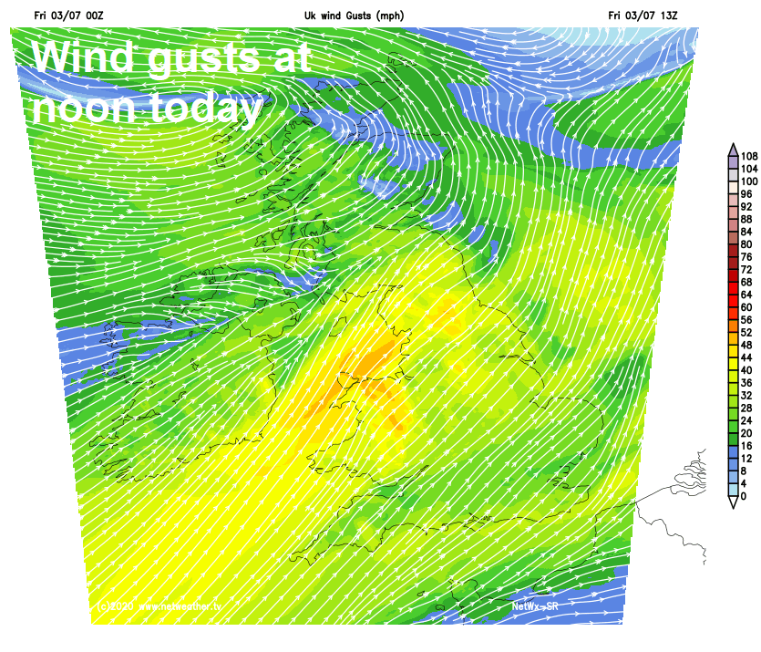
Temperatures nothing to write home about for early July, reaching 14-15C across Scotland, 18-21C across England, Wales and N. Ireland. A strong southwesterly wind across all parts making it feel cooler too.
Much of the UK will be cloud and windy overnight, becoming dry for a time across Scotland, patchy outbreaks of rain across England and Wales, before more persistent and locally heavy rain spreads east across N. Ireland, southern Scotland and northern England in the early hours. Any rain across southern areas generally light and patchy.
A rather cloudy day for most on Saturday, with further outbreaks of rain or drizzle across many parts, rain persistent and locally heavy for a time across southern Scotland and northern England, before rain turns more patchy and lighter away from western hills. Eastern areas seeing the best of any drier conditions. Despite the cloud and strong southwesterly wind gusting to 30-40mph locally, it will feel humid, temperatures reaching 20-23C across central and eastern areas of England, the north and west reaching 17-19C.
Rather windy again on Sunday, as an unseasonably deep area of low pressure crosses the north of Scotland, bringing a spell of wet and very windy weather with gales across Northern Ireland, Scotland and the NW of England first thing, before clearing to sunshine and blustery showers here for the rest of the day, as a cold front sweeps east across all parts, clearing away the humid air. The rest of England and Wales seeing early cloud and patchy rain clearing away through the morning to bright but windy conditions, with scattered showers towards western coasts. Temperatures ranging from 16-18C in the north to 18-21C in the south.
Monday cool in a brisk northwesterly wind as low pressure moves away to the east, with scattered showers spreading southeast across many parts, though the far south may stay dry. Tuesday looking largely dry, bright and less windy, as a transient ridge of high pressure builds in. Wet and windy at times on Wednesday and Thursday across the north, dry and bright in the south, as high pressure hangs on. Low pressure close to the UK to end the week could see most parts seeing showers or longer spells of rain on Friday.