More hot weather this week, with temperatures into the 30s celsius and becoming more widespread by Thursday. The risk of thunderstorms increases too with some cracking storms possible by Thursday night and into Friday.
Yesterday the top temperatures were 28.6C at Heathrow, Cardiff 25.3C and Hull at 26.9C. Today temperatures for England and Wales will tip into the thirties Celsius in some spots. The heat will build further by Thursday yet be gone by the weekend as low pressure moves over the UK from the Atlantic with fresher air. There is the risk of thunderstorms in the far NW on Thursday and more on Friday as the change from humid heat and sunshine to heavy showers with more cloud takes place.
This heat and sunshine may bring you happiness and joy, for others discomfort and irritation.
Grass pollen is very high today for most of the UK except northern Scotland. UV levels will be high so remember your sunscreen and hat. The air pollution levels are forecast to be moderate today for England and Wales and more widespread tomorrow.
As the Met Office Heat-Health alert is at level 2, PHE social and healthcare services are notified to ensure readiness and swift action to reduce harm from a potential heatwave.
“Advice: Hot weather can be dangerous, especially for the very young or very old or those with chronic disease.”
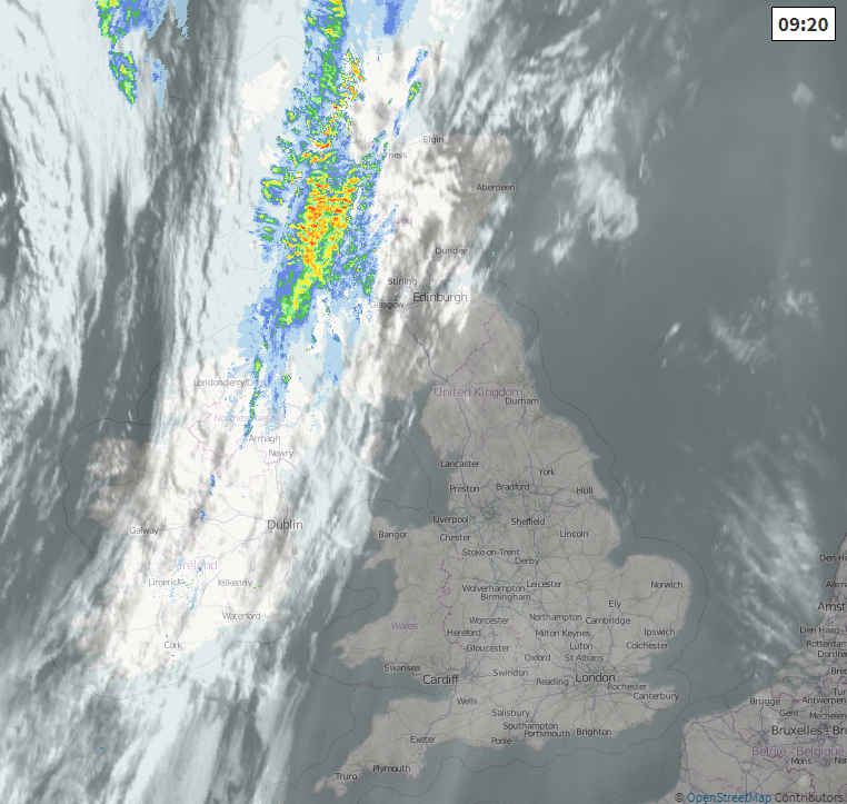
Sea breezes will bring some relief around coasts as the temperatures soar inland. Northern Ireland and Scotland have more cloud this morning with frontal rain which is heavy for western Scotland. This rain will ease this morning and more bright spells appear.
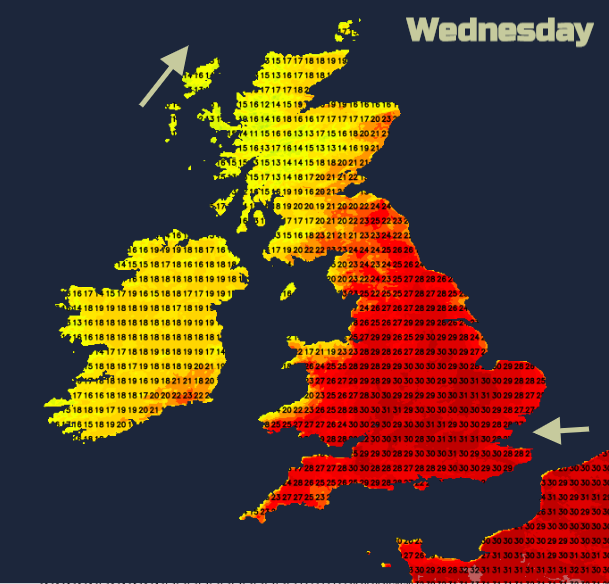
Temperatures mostly stay in the high teens although Belfast 20C and Aberdeen 24C as eastern and southern Scotland move into the low 20sC, maybe even mid 20sC. For England and Wales, there is a lot of sunshine and it will be warmer than yesterday. Leeds 31C and Oxford 30C. Thursday will be hotter still.
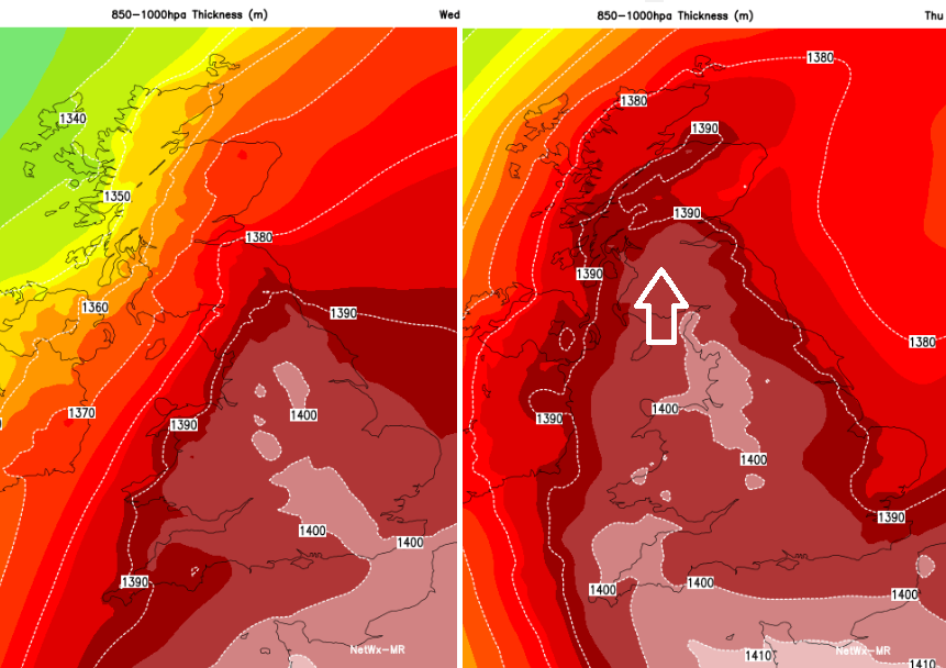
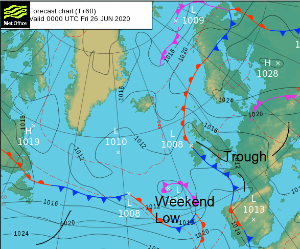
There is low pressure over Iceland, high pressure over Denmark, this front bringing cloud and morning rain. Even though the rain fades that weakness remains and there could be the odd shower overnight for SW Scotland and by Thursday morning, a scattering over the Great Glen heading north. By Thursday afternoon, NW Highland could see isolated thunderstorms breaking out in the heat. For local hillwalkers, do be aware that this risk, although small, does mean that the surface-based thunderstorms breaking out on Thursday afternoon could be severe with torrential downpours, gusty winds, large hail and lightning. There will be more convective action further south by Thursday evening with a plume of very warm air from Spain.
For most Thursday will be a hot, sunny day with a south-easterly breeze. The heat will be more widespread. Northern Ireland into the low/mid 20sC. Scotland could see 30C. England and Wales feeling very warm and muggy with 31 to 33 maybe 34C.
Storm Risk
By Thursday evening there will be elevated storms developing for SW Britain, maybe an earlier pulse for Co. Fermanagh and NW Ireland. The risk over SW England and Wales looks to extend to Northern Ireland and western Scotland during the night. Don’t take the rain location too literally at this stage, view it as a risk with the ingredients present for severe thunderstorms into Friday which could bring torrential rain with surface water even flash flooding, gusty winds, frequent lightning and possibly large hail. Further sightings of funnel clouds even tornadoes can not be ruled out.
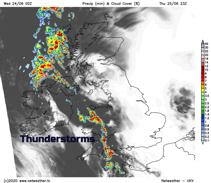
For those wanting a storm chase or after dramatic storm photography, these ingredients will be greeted with much excitement. The thundery band heads NE during Friday. Some areas will miss it all, others see lightning and dark skies in the distance. But for some areas, there will be terrific downpours as the hot humid weather begins to clear out. Michael Fish always says “3 hot days bring a thunderstorm. “