It's the Summer solstice today, but it's not particularly summery just yet as this weekend brings a more typical mixed bag of weather. Next week will be different though, as temperatures hot up with 30c likely to be breached.
It's the Summer Solstice today, but summer proper is old hold for a little longer with a mixed bag this weekend, after what's been an intense week of weather. Next week will ramp up the drama again, but in a different way as temperatures climb, with the 30c barrier set to be breached for the first time this year by Wednesday.
The change will begin to occur early next week, as low pressure to the west of the British Isles and high pressure to the east combine to draw up much warmer air from the continent. The warmth will spread north quite speedily from Tuesday onwards, but the far northwest of the UK will have to wait for the longest to see it and ultimately is likely to be the first to see it end as well. The longevity of the fine, hot spell is quite uncertain at this point; it looks set to last until at least the end of the week, although by this stage some thundery downpours are possible in places. Into next weekend is when the breakdown looks likeliest to occur (right now), as cooler, less settled weather spreads down from the northwest, perhaps preceded by thunderstorms - but this is a long way off.
For now, 30c is certainly not on the cards this weekend with the low-twenties about the peak of any warmth. Today (Saturday) will see some good sunny spells breaking through in many areas but there will also be a scattering of showers around. Some will be on the sharp side but will be few and far between.
Trouble will be brewing out west in the form of a band of rain and strengthening winds during the day though. This will cross into Ireland during from the southwest late morning onwards, reaching the western fringes of England and Wales during the evening. That'll all spread its way east overnight tonight, moving through western and central regions by morning, but taking a while to clear the east on Sunday, with northeast Scotland last to see it leave into the afternoon.
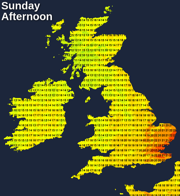
Behind the front which brought the rain will be sunshine and blustery showers which will be more widespread than we'll have seen during Saturday. These will be heaviest and most frequent in the north and west of the country. It'll be a fresh feeling day, with eastern areas seeing the best shelter from the blustery winds, the best chance of staying dry (once the early rain has cleared), and the warmest temperatures. The southeast corner could make it to 22-24c, other eastern and central counties 17-21c, but cooler further west at 14-18c.
Monday then sees the change to warmer, drier weather start to build from the southeast. So, for the southeast half of the UK, it'll be an often sunny day with highs climbing into the twenties. Head further northwest, and it's a different tale, with outbreaks of rain pulsing up from the southwest, strong gusty winds and cooler temperatures.
Into Tuesday, that less settled, cooler zone gets squeezed further northwest, with patchy rain affecting a good part of Ireland and western Scotland in particular. For England and Wales, there should be bags of sunshine and maxes by this point will be on the rise, climbing up into the mid or high twenties.
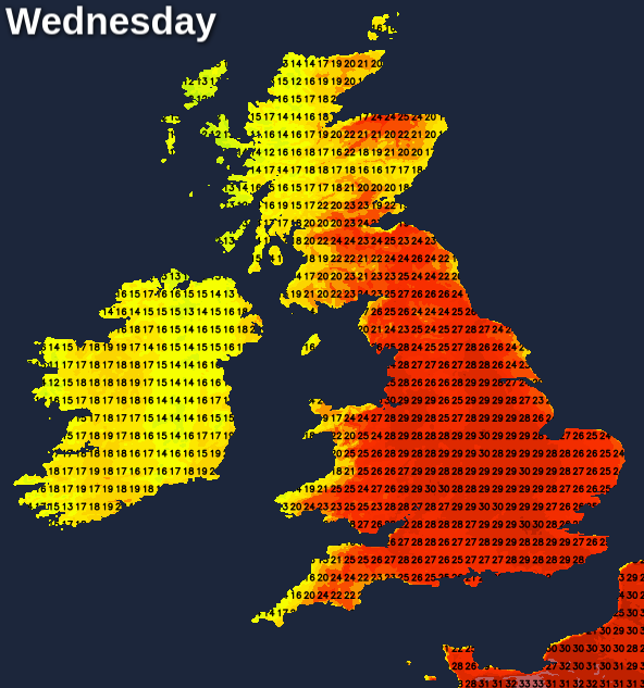
By Wednesday, there's still likely to be some rain affecting Ireland and northwest Scotland, but elsewhere it's dry, very warm if not hot, and sunny. Near to coasts, sea breezes may keep it cooler though. The fine, very warm or hot weather then looks set to continue through to the end of the week, even the northwest of Scotland and Ireland should get in on the act for a time at least.