Further heavy showers and thunderstorms will bring hefty downpours today, with the risk of surface water flooding and lightning. The stormy weather has provided some spectacular sights this week.
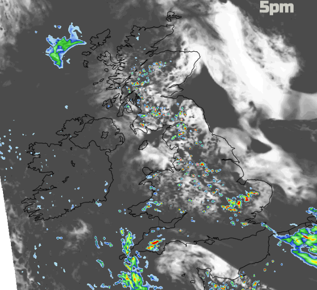
Tuesday produced another day of severe convective action; thunderstorms, shelf clouds, hail, Mammatus, funnel clouds even tornado damage. There are warnings from the UK Met Office again today with warm, humid air, heavy downpours and the risk of thunderstorms into the evening.
If you are thinking, “I haven’t seen any rain, let alone thunderstorms”, well that is the nature of showers. Even within the warning areas.
“One of the most notable aspects of thunderstorms can be the localised nature of the impacts they could bring. This, in particular, can be the case with rainfall amounts, with big differences in amounts that fall from one place to another – and over only a very short distance.” Met Office
There will be some changes by Thursday. There also looks to be some respite from the grey low cloud which has been shrouding eastern Britain for days. It was becoming rather claustrophobic with the endless cloak of grey mist. Oh, to see the sunshine! Today looks more hopeful, but the sea fog will return overnight. London Heathrow managed 24.9C on Tuesday and many parts of the UK continued with the rather muggy air and fine weather, when not facing a dramatic thunderstorm.
To start the day, there are outbreaks of showery rain in the west, for western Scotland, the Isle of Man and Co. Down. There is hardly any breeze. The rain over western Scotland moves off in the Atlantic, Northern Ireland will see more cloud and rain this morning, still showery but heading west. Showers which are already over the Channel Islands will head for Devon and Cornwall with sharp downpours by lunchtime. The inland showers begin to break out for England and Wales, also western Scotland once more. There will be a light wind off the North Sea over eastern England and a slight southerly low from the English Channel. This will be enough convergence to set off showers in central England, still up into the NW.
On Tuesday this resulted in a band of heavy thundery showers by the evening across the Midlands.
Temperatures today; Scotland 15 to 20C, Wales 17 to 21C, Northern Ireland 15 to 19C a bit cooler with more cloud today and a very light north wind. England high teens and low twenties with London again around 24 or 25C. By this evening there could also be heavy showers over SE Britain with an occlusion linking over the Low Countries. This feeds in more rain overnight to the Thames estuary. The heavy showers keep going late into the evening for the West Midlands and Wales.
The feed of rain from the SE nudges northwards and feeds right across the UK. So a wet start for Thursday morning across part of England and Wales. Southern and northern England start off drier, the low cloud will be back off the North Sea. The rain area moves into northern England and more of Wales as showers begin to break out over southern England, inland. The precipitation looks like it is rotating around a low pressure centre and sharp showers appear for Northern Ireland, mainly for western and southern counties. As the low nudges westwards, bands of rain move over NW England and the Bristol Channel as sunshine appears for SE Britain. Scotland and Co Antrim will enjoy sunny skies and some fine warmer weather although the NE to E breeze off the North Sea picks up during the day
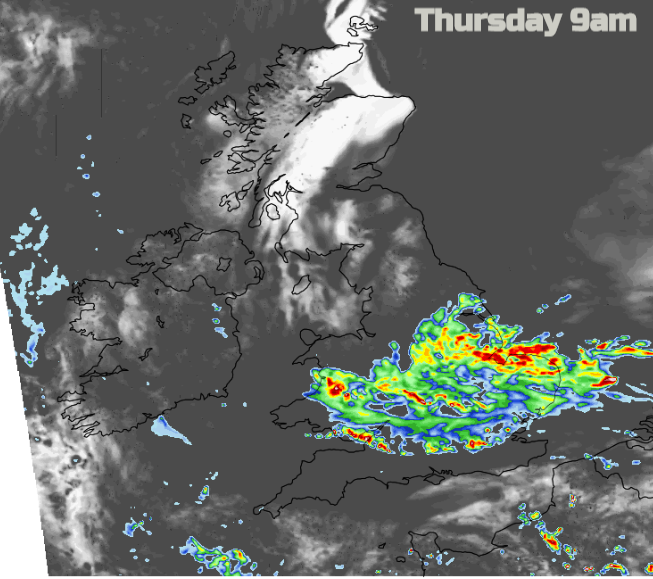
There is another Met Office warning, this time for Rain on Thursday afternoon and evening, rather than a Thunderstorm warning. That does seem rather confusing. Maybe there is more emphasis on the flooding aspect of this rain. The Environment Agency mentioned that small rivers would respond later in the week from the ongoing rains whereas urban areas have been at risk of surface water flooding immediately as thundery downpours hit.
However, there is still a risk of heavy showers and thunderstorms breaking out on Thursday. For inland southern England but also north of London and north of the M4. These would be separate to the large area of rain which moves across England and Wales, west to east.
The swirling rain bands move over SW England and Northern Ireland, SW Scotland by Thursday night. Friday looks more breezy with lingering outbreaks of rain in the north and the easterly wind veering to a south-westerly. Fresher air will reach SW Britain, although the close, warm conditions persist elsewhere.