A warm & humid weekend for the UK, with sunny spells and thundery downpours in places, particularly across England and Wales. Cool, grey and misty in the northeast.
Many places will see some rain, showers or even thunderstorms at some point this weekend, thanks to an area of low pressure moving in close to the southwest. However, it won’t rain all the time and there will be some warm sunshine and feeling humid too, as warm and moist air is pulled northwest across Britain from the near continent. However, it will be cool near eastern coasts thanks to an onshore breeze off the cool North Sea – with some mist and low cloud possible here.
This morning, generally cloudy for northern England northwards across Scotland. An area of heavy thundery rain moving northwest over the North Sea all the way from Belgium and Holland will continue to spread northwest across the far north of England and southern Scotland through the morning. A risk of thunder and lightning towards North Sea coasts. Staying generally dry across northern Scotland, perhaps with some brightness or sunshine in the far northwest. Further south, ia generally dry and sunny morning south of northern England – these sunny conditions spreading north across northern England too. Some area of high cloud here and there making the sun hazy. Thicker mid-level cloud across SW England could bring some showery bursts of rain later this morning though.
Through the afternoon, much of England and Wales remaining dry and sunny and becoming rather warm and feeling humid, with lighter winds than recently. Mid-level cloud spreading northwest across SW England and south Wales will bringing some showers at times, heavy locally with the odd rumble of thunder. Also, we could see some isolated heavy showers and thunderstorms develop across parts of mid and north Wales, the Midlands and NW England, as rising temperatures and breeze convergence trigger some cumulonimbus clouds to grow. Any thunderstorms could produce hail, frequent lightning, localised flooding and gusty winds. But they will be hit-and-miss, with many places in these areas staying dry.
Showery rain continuing across southern Scotland this afternoon, spreading into the Highlands at times, the odd rumble of thunder can’t be ruled out. Northern Scotland staying mostly dry and bright or sunny, grey and misty towards eastern coasts of Scotland.
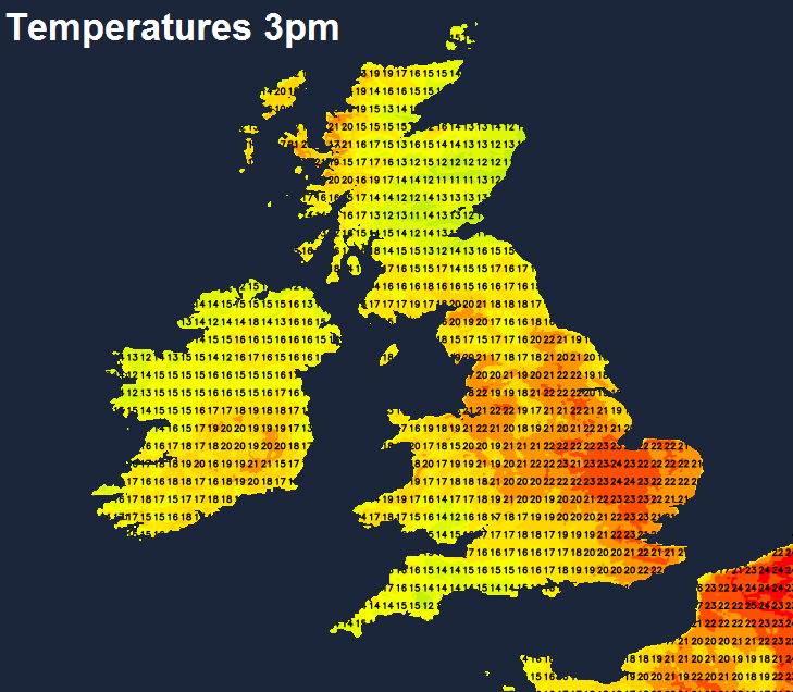
Temperatures this afternoon reaching 21-24C inland across England and Wales, feeling humid too. A southeasterly breeze, which make North Sea coasts cooler, particularly NE England where mist and low cloud will mean temperatures reach 16C at best. Scotland and N. Ireland reaching 18-20C, again cooler along eastern coasts.
Through this evening, localised heavy showers and a few thunderstorms continuing for a time across the west and north before clearing away northwestwards. Further heavy showers and perhaps some thunderstorms developing across southern England before clearing northwest across the Midlands and Wales overnight. Drier conditions with clear spells following from the southeast across many parts in the early hours. Though mist, low cloud and drizzle will affect eastern Scotland and NE England.
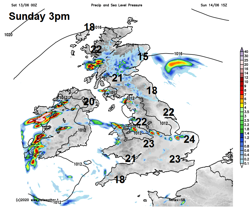
Sunday will see grey skies from low cloud across eastern Scotland and NE England, with mist over hills and coasts and some patchy rain or drizzle too. Elsewhere, warm sunshine for many, but like today, some scattered slow-moving heavy showers and thunderstorms developing, mostly across SW England, Wales, Midlands and northern England. Many places will miss them in these areas and stay dry though. Afternoon highs widely reaching 21-24C, cooler along the cloudier coasts in the northeast, where temperatures will be pegged back in the mid-teens.
Area of low pressure will still be close to the southwest on Monday, but will tend to weaken, so winds will be light generally, with another day of warm sunny spells for many, but some scattered slow-moving heavy showers and some thunderstorms developing, mostly across the west.
Eastern areas staying mostly dry. Shallow low pressure hanging around across the south for much of the rest of the week, so much of the UK will see a mixture of warm sunny spells but also scattered heavy and perhaps thundery showers developing each day.