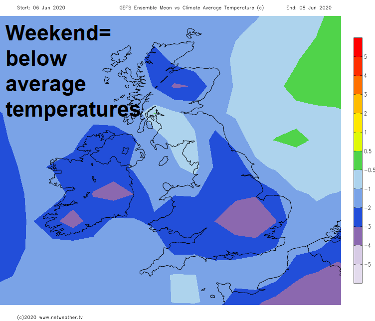
Yes, it's early June, but the weather won't feel like it over the next few days, with a strong cold northerly wind, heavy showers and even some snow over the tops of the Scottish mountains.
Heavy showers, rain, gales and Scottish mountain snow sounds like the weather more associated early Spring than the start of Summer, but it is in the forecast for the next few days, as we see an unseasonably deep low track south close to the east coast of Britain over the next 36 hours, bring chilly northerly winds. It will stay cool and windy on Saturday with gales in the north along with showers or longer spells of rain for most spreading south. Less windy on Sunday with showers becoming confined to eastern England. The improving picture will continue into Monday – which looks largely dry, rain spreading southeast Tuesday, but the rest of the week looks to see high pressure build with an increase in sunshine and also rise in temperatures.
For now, clusters of heavy showers across northern and eastern England will continue to spread southeast across the Midlands and East Anglia and SE England through the morning after a dry start. Then showers developing more widely into the afternoon across England and Wales, as the sunny spells heat the ground and build cumulonimbus clouds in the cold air aloft. Some thunderstorms, developing across northern and eastern England in particular, which may be accompanied by hail and gusty winds. Fewer showers for south Wales and SW England, with some spots staying dry and sunny.
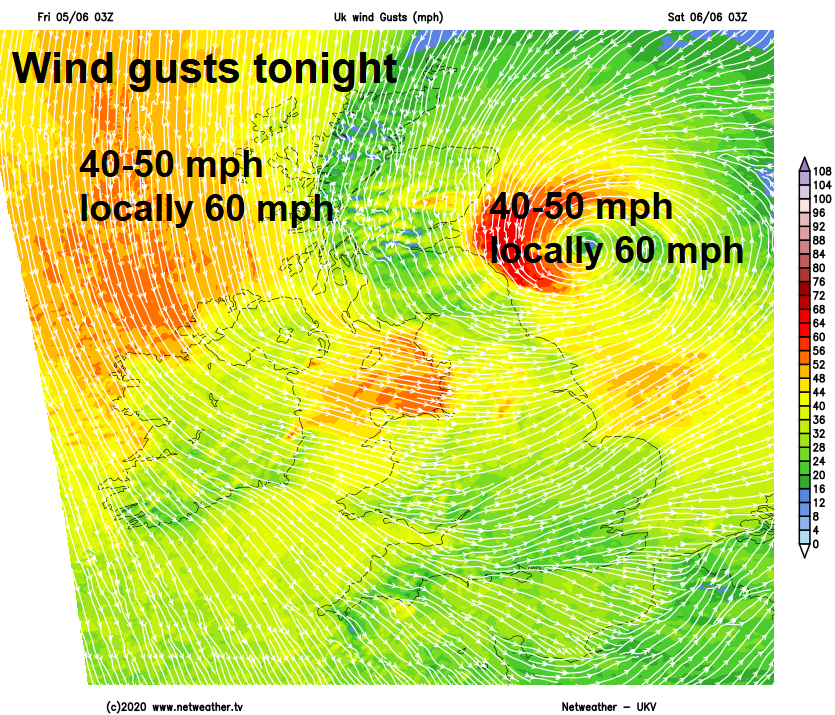
Scotland has seen showers from the word go this morning across northern and eastern areas, heavy across the far northwest. Showers will continue this morning in these areas, drier towards SW Scotland, then the showers will be replaced by thickening cloud and outbreaks of persistent rain spreading southwest across most parts through the afternoon, though south of the central belt perhaps staying dry. Gales developing, particularly over hills and around coasts, with gusts of 40-50mph this afternoon.
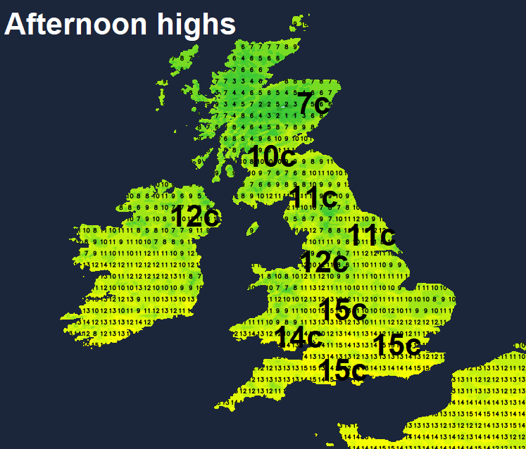
A cool day for all in the strong north to northwesterly wind. Afternoon highs reaching 10-13C in the north, 14-16C in the south.
Areas of persistent rain will continue to spread south across Scotland, N. Ireland and then northern England this evening and overnight, sleet and snow possible over higher parts of the Highlands. Very windy here too, with gales across northern and western Scotland, with gusts of 45-55mph. Further south across England and Wales, most showers will die out to leave a mostly dry, cool and windy night with clear spells.
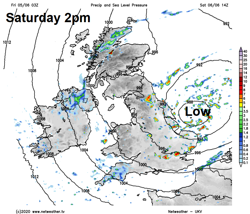
Another blustery and cool day on Saturday, as an unseasonably deep area of low pressure slides down the east coast of England. An occluded front will slide south with the low, bringing a band of rain south across Wales, Midlands, southern England and East Anglia through the morning, followed by sunny spells and scattered blustery showers driven south by a strong to gale force northerly wind across all parts, showers will turn heavy with hail and thunder in places across central and eastern areas, perhaps longer spells of rain across eastern Scotland. Temperatures rather disappointing for early June, reaching 13-16C at best.
Somewhat calmer on Sunday, as low pressure moving down the North Sea weakens, with winds easing and showers or longer spells of rain becoming increasingly confined towards the east coast of England through the day with increasing sunshine and just isolated showers spreading from the west. It will feel a little warmer as a result, temperatures reaching 15-18C, though cooler across far north of Scotland and eastern coasts – with 10-14C more likely.
Generally cloudy, cool but mainly dry through Monday, though a few showers could develop across Wales and SW England for a time. Perhaps a dry and bright start across England and Wales on Tuesday, thickening cloud across Scotland and N. Ireland as a band of rain spreads southeast, reaching northern England and Wales in the afternoon, staying dry further southeast. Rain clearing SE England Wednesday morning, then it looks like high pressure building in from the west for the rest of the week, with increasing sunshine and also temperatures on the rise back into the low twenties Celsius across the south.