


The UK's weather is locking-in to a new, less settled and cooler normal for the time being. With rain, showers and strong winds associated with low pressure in the North-Sea becoming feature during the coming days.
Yesterday almost had novelty value. It's been so unusual to see rain on the radar or not have highs into the twenties lately. The cooler, unsettled weather is going to become the norm for the time being though. It even ramps up a notch Friday and into the weekend as a North Sea low pressure system sinks down the eastern side of the country bringing some persistent rain, showers and gusty winds.
For today, it's a case of a few bright or sunny spells, a fair bit of cloud and a reasonable scattering of showers. The bulk of the showers have started the day in the north and northwest, but they will move southeast as the day wears on. There'll be some heavier ones amongst them too, with a few rumbles of thunder not out of the question. It'll be a cool feeling day, particularly in the north to northwest breeze blowing in many places.
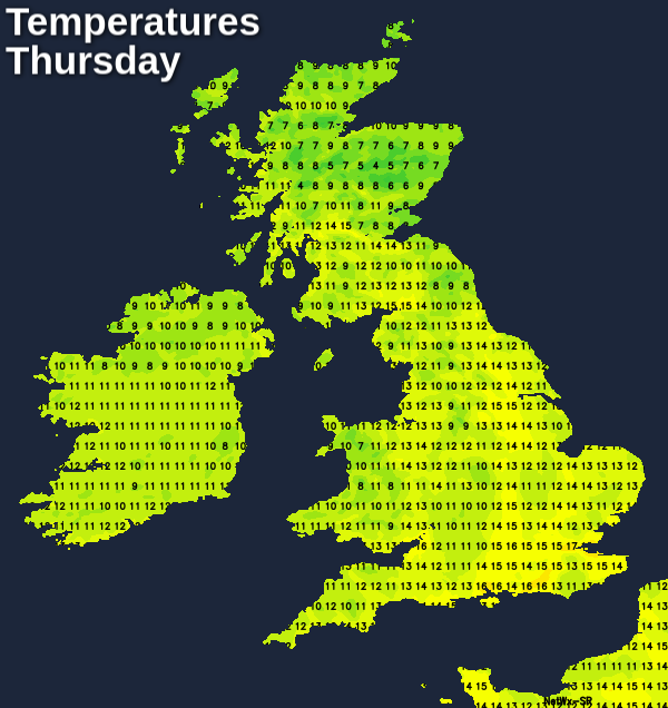
Temperatures will be warmest in the south and southeast of the country, with highs of 15-17c, elsewhere 12-15c will be more like it and a few degrees down on that near to northern and western facing coasts. The average for the time of the year is 14c in Northern Scotland and 19c in Southern England.
Overnight tonight, most but not all of the showers will die out. It'll be mainly near to coasts where they persist, but the odd one may hang around inland. Most places will cool off into single-figures, there could even be a touch of frost in the Highlands.
Friday then continues where Thursday left off, with sunny spells and some sharp showers. But, low pressure will be developing and moving in from the east towards Scotland. That's going to bring persistent rain into the northeast of Scotland initially, spreading south and west through the day. It'll also bring gales to coastal areas of Scotland, Northern Ireland and northern England by the end of the day.
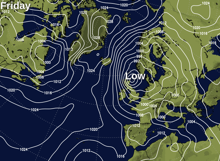
The low will then slide down the east coast of the UK overnight and into the start of Saturday, taking its rain and strong winds south as it goes. The rain will become more patchy the further south it heads, but it'll still be a noticeable feature, bringing at least some (much needed) rain and the strong winds will continue for much of the weekend - especially near to the coasts.
The patchy rain could take some time to clear the south and southeast during Saturday, with another band moving southeast through Scotland and into the far north of England during the day. Away from those two zones, it should be mostly dry with some brighter or sunnier spells and just a few showers. Highs across England and Wales are likely to peak at a respectable enough 15-18c, a few degrees cooler than that in Scotland and Northern Ireland though.
Sunday will see that rain potentially affecting parts of Eastern England, moving south all the while, although there is some uncertainty over this. Away from that threat, there should be a good deal of dry weather. But with the risk of a shower here and there. Temperatures will about be on a par with Saturday, maybe even a degree or so warmer in some western and central parts.


