The record-breaking Spring sunshine keeps on coming this weekend and continues into the start of Summer too.
It's now official this has been one of the driest, sunniest springs ever and as I speak, a local record for May of 259.7 hours of sunshine at Nottingham Castle set in 1922 as just been surpassed. A Campbell Stokes recorder has been kept at the Castle since 1899, so it's now locally the sunniest May for at least 121 years.
So with another day of virtually continuous sunshine across most of the country, the advice is 'slap on that sun cream' and wear a hat, as UV levels will be particularly high again. There was some patchy mist and low cloud over eastern slopes of the Pennines and to the South of London first thing, but this is already burning off. High cloud over Scotland and Northern Ireland will also weaken the sunshine a little, but shouldn't spoil another lovely late spring day too much.
The best of the warmth will be over sheltered parts of northern Scotland and in the West, where temperatures could reach a hot 27 or 28C again in just a light South Easterly breeze. For most though, 22 to 25C will be nearer the mark, with an East or North-East wind keeping eastern areas somewhat cooler, where exposed North Sea coasts may struggle to reach 14 to16C despite the strong sunshine.
It'll be a fine, warm summery evening, but in eastern areas, it'll begin to feel a little chilly in the wind towards dusk, so bear this in mind if you're having a barbecue. A fine, largely clear night will follow in a light or moderate East or North Easterly breeze, with patchy mist and low cloud returning to some eastern parts before morning. Despite the chilly feel, temperatures shouldn't fall below 6 to 10C.
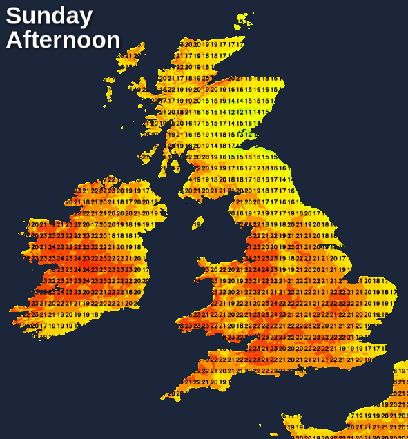
It's another story of sunny skies on Sunday, once patchy mist and low cloud have cleared from some eastern areas. It continues very dry, but some patchy cloud may bubble-up, with just the outside chance of the odd sharp shower developing later over Highland Scotland. After a chilly start, It becomes very warm, with 27 or 28C possible yet again over sheltered parts of the West and North. Elsewhere 23 to 25C is made more tolerable by an East or North Easterly breeze that continues to keep exposed North Sea coasts much cooler.
Another fine, summery evening will be followed by a dry and mostly clear night, but with patchy mist and low cloud returning to give some eastern areas a grey start to the new month and the start of meteorological summer. It'll turn chilly again overnight, with lowest temperatures mostly between about 6 and 9C.
After two months of very dry, sunny weather, we have a drought situation developing. Although turning more cloudy and cooler in the next few days after more sun to start to June, the first week of the new month offers little in the way of rain as winds turn into a northerly quarter. These'll bring a few showers mostly to the North and East, but they'll be mostly light, with many western and more southern areas continuing to be mainly dry and bright.