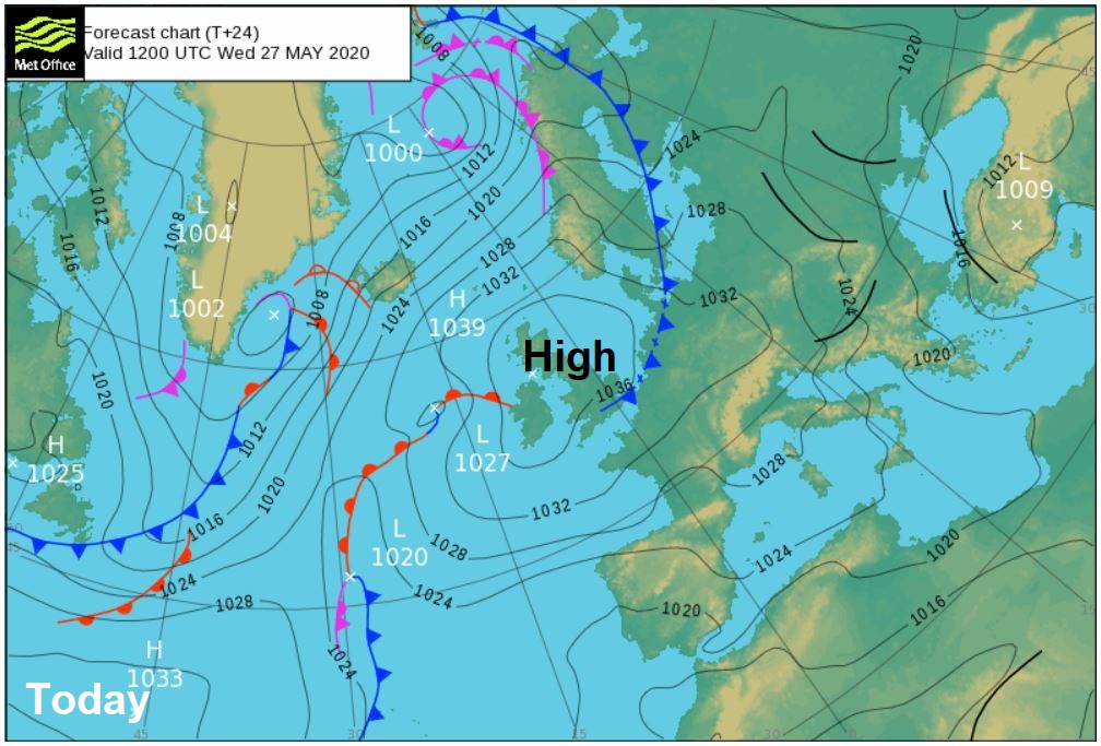
High pressure continues to dominate our weather until at least early next week, with most staying dry and fine. The warm conditions will spread north, and the highest temperatures will transfer to the west as the high moves east and eventually over Scandinavia.
For many, it’s going to be another dry, sunny and warm day, thanks to high pressure centred over northern Britain. The centre of the area of high pressure will then drift east over the North Sea towards the end of the week, allowing a southerly flow to develop, spreading warmth north across all parts, with temperatures reaching the low twenties across Scotland, and the mid-to-high twenties Celsius across parts of the south and west. High pressure will end up centred over Scandinavia this weekend, meaning a brisk easterly wind develops keeping eastern areas cooler, with the highest temperatures, in the mid-to-high twenties Celsius towards the west, but for most it will stay dry, sunny and warm.
High pressure firmly in control until at least early next week, with most staying dry and fine:
For now, it’s another fine and sunny start across England and Wales, some patchy cloud across south Wales, Midlands and East Anglia from the remnants of an old front and some sea fog around northern coasts of Cornwall and Devon, but for many blue skies. A cloudier start across the far north of England, much of Scotland and N. Ireland with the odd spot of light rain or drizzle.
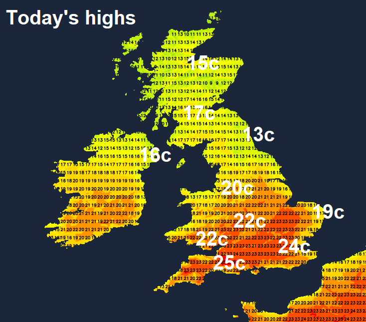
It will stay dry for most, best of the sunshine across England and Wales, cloudier across Scotland and N. Ireland, though eastern areas of Scotland should see cloud break through the morning to allow some sunny spells, cloud thickening across western Scotland with some patchy rain arriving later. Afternoon highs reaching 22-25C across south Wales, Midlands and southern England Cooler further north, with 15-19C across north Wales, northern England, Scotland and N. Ireland. Onshore breeze along North Sea coasts keeping these areas in the high teens too.
As we head through Wednesday night, generally cloudy across Scotland and N. Ireland – with outbreaks of rain spreading east across the northern half of Scotland. Dry with clearer skies further south across England and Wales.
Thursday
Early rain clearing NE Scotland then after a cloudy start it should slowly brighten up across Scotland with a mostly dry, sunny and warm afternoon, though some places staying on the cloudy side. The best of the blue skies and sunshine across England, Wales and N. Ireland. With southerly winds, the warmth reaching further north than recent days, so we’ll see temperatures reach 22C in Glasgow, 20C in Belfast, further south reaching 25C in Liverpool and Cardiff, 23C in London. Cooler towards eastern coasts with an onshore breeze of the North Sea.
Dry with widespread sunshine on Friday, blue skies for many, and with a southerly flow in the west – here we’ll see the highest temperatures – reaching 24C in Glasgow, 25C in Liverpool, 26C in Cardiff. A little cooler towards the east with 21C in Newcastle and 23C in London. Onshore breeze across East Anglia and Kent keeping temperatures in the high teens towards North Sea coasts here.
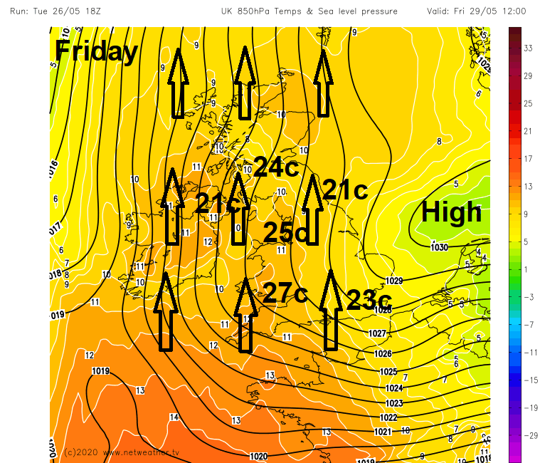
High pressure will remain dominant over the weekend, so for most, it will stay dry and fine. With high pressure centred over Scandinavia, an easterly breeze will pick up keeping eastern areas cooler with the highest temperatures in the west. Temperatures will be widely in the low to mid-twenties inland away from eastern coasts, perhaps high twenties across south Wales and SW England. A weather front could bring a band of cloud and some showers across the far west of Scotland along with the north and west of N. Ireland.