Low pressure is arriving to bring an unsettled blip to our weather during the coming days, with some rain or showers at times, the threat of the odd thunderstorm and some very strong winds. High pressure will be back soon enough though.
After the hottest day of the year so far yesterday, there are changes afoot as we head into a temporary, less settled spell of weather as low pressure moves in. Earlier this week, today looked a bit more explosive than it's going to be, although there is still the chance of some thunderstorms in the east of England during the coming hours. As the low pressure moves in later and into tomorrow, a spell of rain will push through, but away from the west and north it won't amount to a great deal (sorry gardeners!). The other part of the story will be the wind, with gales in the northwest in particular.
Today, as the breakdown gets underway, we have a couple of weather fronts moving across the country. There's one across the eastern side of the UK this morning, which has been bringing some showery rain. It's this which may aid in the development of storms in some eastern counties of England. It'll clear by lunchtime, to leave a lot of warm sunshine once again, with just the isolated thundery shower likely to continue to affect East Anglia and southeast England into the afternoon.
The other front is further west this morning and is bringing some wet weather into northwest England and western Scotland. It'll move east through the day, with the rain on it become ever more patchy as it does so - with the last of it clearing northeast Scotland this evening.
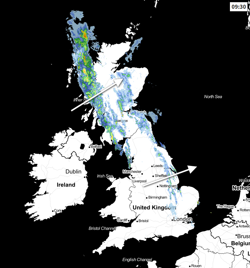 View the live weather radar here.
It'll be another warm day for England, Wales and Southern Scotland with temperatures widely into the high-teens or low-twenties. The southeast corner will be warmer still, with maxes of 24-27c, but on the flip side, the northern half of Scotland will be cooler at 13-16c typically.
Through the latter part of the afternoon and into the evening, cloud will thicken from the southwest as low pressure moves closer. Winds will also increase in southwest Ireland, with gusts of 60mph+ in exposed places. The rain will also cross into Ireland this evening, moving steadily northeast and getting into the western fringes of Britain by midnight. It'll then continue its journey to clear the east of the UK during tomorrow morning. The heavier, most persistent rain will be reserved for the north and west, whereas those further southeast may barely even see a splash from it.
Once the rain has cleared, Friday will be a day of sunshine and blustery showers. The strongest winds and most frequent showers will be in the north and particularly the northwest, where gusts of 50-65mph or so are likely. The further southeast you are, the less likely showers will be, you'll also see more sunshine and have lighter winds. Temperatures will reach in eastern England, especially the southeast and East Anglia. Other parts of England and Wales will see the high-teens, with Scotland and Northern Ireland cooler at 11-15c.
Saturday is likely to see a more widespread shower risk, albeit with the northwest seeing the largest share of them. It'll be windy or blustery in many parts, with the northern half of Scotland seeing the strongest gusts of up to 60mph, as the low pressure moves just to the north of the country before heading into the North Sea later. It'll be a fresher day than Friday with temperatures generally a few degrees down.
By Sunday, high pressure will be building back into southern areas, but further north there'll be more rain. So, the weekend ending similarly to last week with a north-south split.