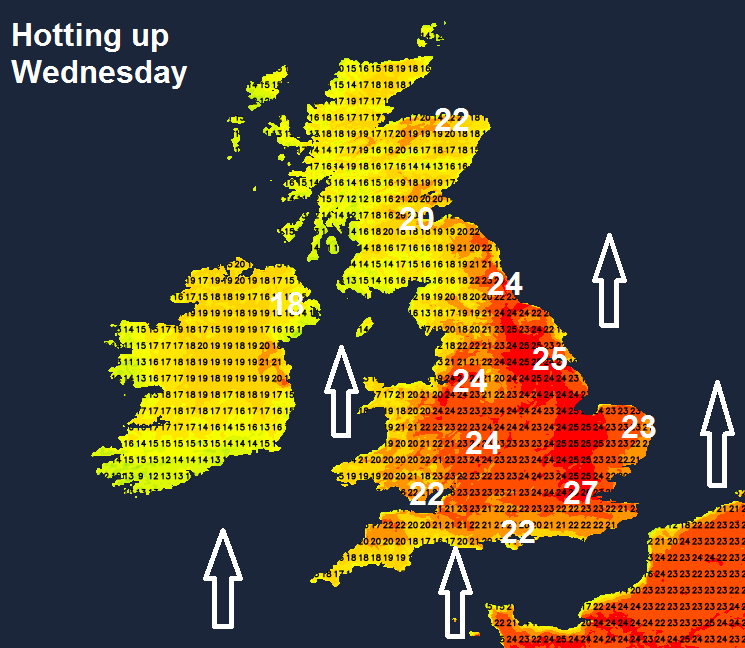
The first part of this week will see temperatures climbing widely into the low-mid twenties with 28c possible in Eastern England. The second half sees the weather turns less settled, thanks in part to a UK bound low pressure system, formed with some of the energy from tropical storm Arthur.
It will turn increasingly warmer through the first half of this week, as high pressure drifts east and a southerly flow develops, bringing a surge of warm air northwards. Temperatures will widely reach the low to mid-twenties Celsius on Wednesday, perhaps 28C across eastern England. There will be more in the way of cloud and some rain in the north at times though. By the end of the week it will turn cooler, windier and more unsettled from the west, thanks to low pressure, spawned by the remnants of Tropical Storm Arthur, heading our way. But there will be little in the rain for parched gardens in the south.
For now, it’s a dry bright or sunny but breezy morning so far across east Wales, central, southern and eastern England. Cloudier across the northern half of Britain and the far west, with some patchy light rain or drizzle here and there, with some more persistent rain across northwest Scotland.
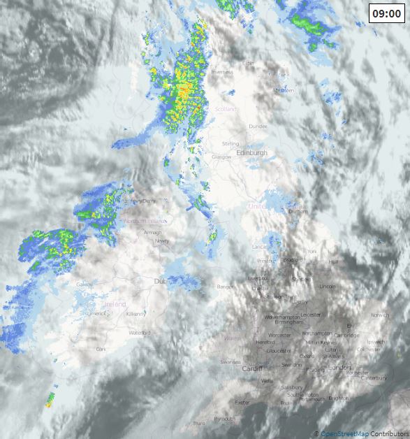
The more persistent rain in the far northwest will tend to clear away through the morning, but it will remain often cloudy through the day across Scotland, N. Ireland, northern England and west Wales, with occasional bursts of mainly light rain or drizzle towards the west. But for east Wales, Midlands, southern England and East Anglia it will remain dry with plenty of sunshine, warmer here too.
Afternoon highs reaching 21-24C in the sunnier south, where we have the cloudier skies in the north and far west temperatures reaching 16-18C, though cooler around western coasts with the brisk breeze.
This evening and overnight it stay largely cloudy and breezy across the northern half of Britain with further showers or longer spells of rain spreading northeast, more in the way of cloud across the south but staying dry, with some clear spells at times. A generally mild night though, with temperatures away from the far north no lower than 10-12C.
Largely cloudy again across the north tomorrow, with some patchy rain pushing northeast, misty and murky around western coasts and hills too. Like today, east Wales, Midlands, southern England and East Anglia brightening up after perhaps a cloudy start in places, with some decent sunny spells developing and staying dry and warm. Temperatures reaching 16-18C in the cloudier north, but where we see the sunshine in the south 20-23C, perhaps 25C in the southeast.
High pressure close to the south today and tomorrow expands further north on Wednesday, so probably the sunniest day of the week UK-wide, with much of the north that’s been cloudy brightening up too, with much of Britain dry and sunny. The warmest day of the week too, as we draw in a southerly flow off continental Europe, temperatures widely reaching the low 20s Celsius from the central belt of Scotland southwards, mid to high twenties across central, southern and eastern England. Cooler around coasts along with the far north and far west.
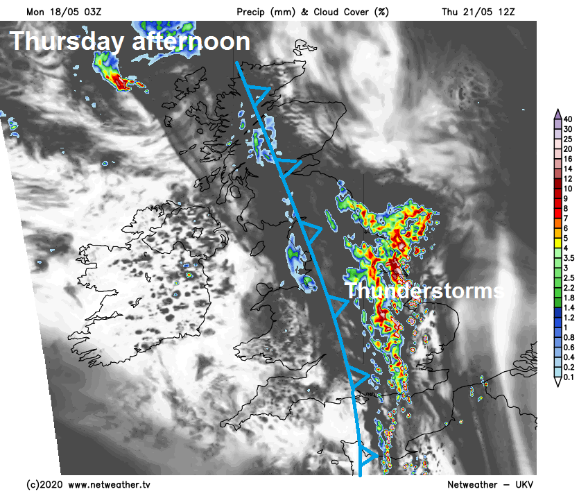
We will start to see a breakdown from the west to the fine and warm conditions on Thursday, as a cold front sweeps in from the west. We may see some thunderstorms break out across central and eastern areas ahead of this front – where very warm air will hang on, the front will bring a band of cloud and a little rain east, then turning cooler but sunnier again behind the front across northern and western areas.
A deep low, spawned by the remnants of Tropical Storm Arthur, will sweep northeast past the west of Ireland and west of Scotland on Friday, bringing cooler and windier conditions behind a cold front which will bring a band of cloud and a little rain eastwards, followed by blustery showers and gales in the northwest.
Cool, cloudy, windy and showery conditions probably persisting across the north at the weekend, but drier and brighter across the south, as high pressure begins to re-assert itself.