


Low pressure is going to be right over the British Isles today, bringing the montha0to an end with a rash of heavy, thundery April showers.
Low pressure is going to be right over the British Isles today, bringing the month to an end with a rash of heavy, thundery April showers. Nowhere will be immune from catching one during Thursday, but once the low has moved off into the North Sea on Friday, the bulk of the showers will be down the eastern side of the country.
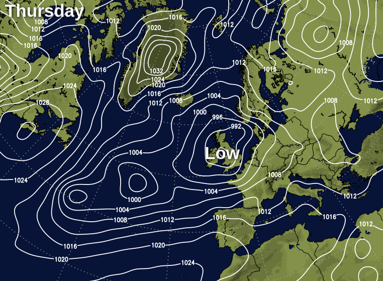
As you may expect with a low overhead, sunshine will be at a premium today, but there will be some glimpses of it between the showers and perhaps for longer periods in southern and central England to end the day. Either way though, it'll not be a warm day by any stretch, with highs typically reaching 10-13c. It'll also be blustery, although Scotland will see the winds fall light later on, as the low crosses northern England. Keep track of the latest on the radar.
If you or your children are camping at home tonight, it'll be a chilly one, with more showers at times, although they won't be as widespread as during the day.
Into Friday and the start of May, it'll be another showery day, but the focus of the showers will move east as the day wears on. That'll allow more sunny spells to arrive into western, central and southern England, along with Wales by the afternoon. There are still liable to be a scattering of showers in those regions though, but the more widespread downpours will be in eastern counties and across the southern half of Scotland. The winds will still be a noticeable feature though, which will make it feel fresh, even though temperatures may be a degree or so higher in those sunnier parts.
A handful of showers will last into the night again, but many parts stay dry. Then, Saturday starts the weekend with a familiar theme of sunny spells and scattered showers, with the showers still being blown through on a keen, but slowly easing northwest wind. Some warmer air will be starting to get into southern parts by this point, with highs of 15-17c here, elsewhere 13-15c will be more like it.
Sunday then throws a bit of a curveball, as there's the threat of some rain moving up into southern areas. The problem at the moment is just how far that's going to get - some models have it just clipping into the far southwest, whereas others take it further across other parts of the south, and maybe even up into central areas. Away from that complication, it's a bit more straight forward with sunny spells and showers - most of those affecting eastern parts. Temperatures could be a little warmer than Saturday, with southern parts climbing toward the high-teens, if the rain stays away.


