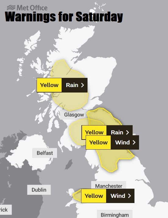
Windy Saturday, particularly in the north, rain slowly sinking south reaching the south tonight, clearing to showers Sunday. A few deep lows could bring gales and heavy rain for all next week.
Friday saw a mostly dry and bright day, thanks to a brief ridge of high pressure building in from the Azores. However, pressure will drop through the weekend with strong winds and heavy rain affecting northern areas today. Wind gusts reaching 50-70mph across SE Scotland, northern England and north Wales could cause some disruption. Cloud and rain across reaching the south tonight before clearing Sunday morning, otherwise tomorrow turning brighter but still windy with showers in the west. A deep low to the northwest on Monday will bring a very windy day, particularly in the west, with gusts reaching 60-70mph along coasts, also turning wet here by the evening. Further developing low pressure systems are then expected to cross the UK for the rest of the week, bringing further gales and heavy rain across many parts.
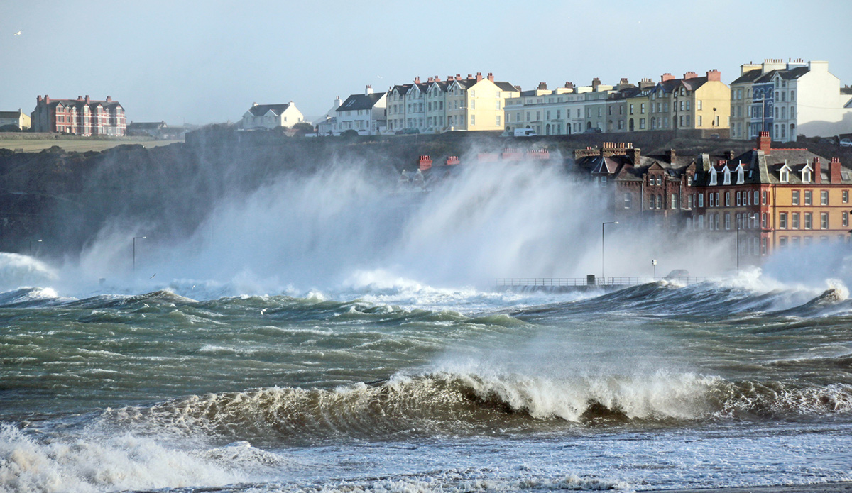
For now, it’s a frost-free, mild, grey and windy start for many this morning, with southwesterly gales up through the Irish Sea and affecting west Wales, Cumbria, southern and eastern Scotland, recently gusts reaching 55-65mph in places. There is also some persistent rain affecting much of Scotland away from the east coasts, Northern Ireland and Cumbria, heavy over higher ground. Elsewhere the generally grey skies are bringing some patchy drizzle in places.
The rain across Scotland and N. Ireland will move southeastwards only slowly through today, so several hours of rain to come here before it clears to brighter but showery weather this afternoon. More persistent rain spreading down across northern England, north and west Wales through afternoon, but the rest of England and Wales mostly cloudy and windy with patchy drizzle in places, perhaps some limited brightness coming through towards SE England and East Anglia.
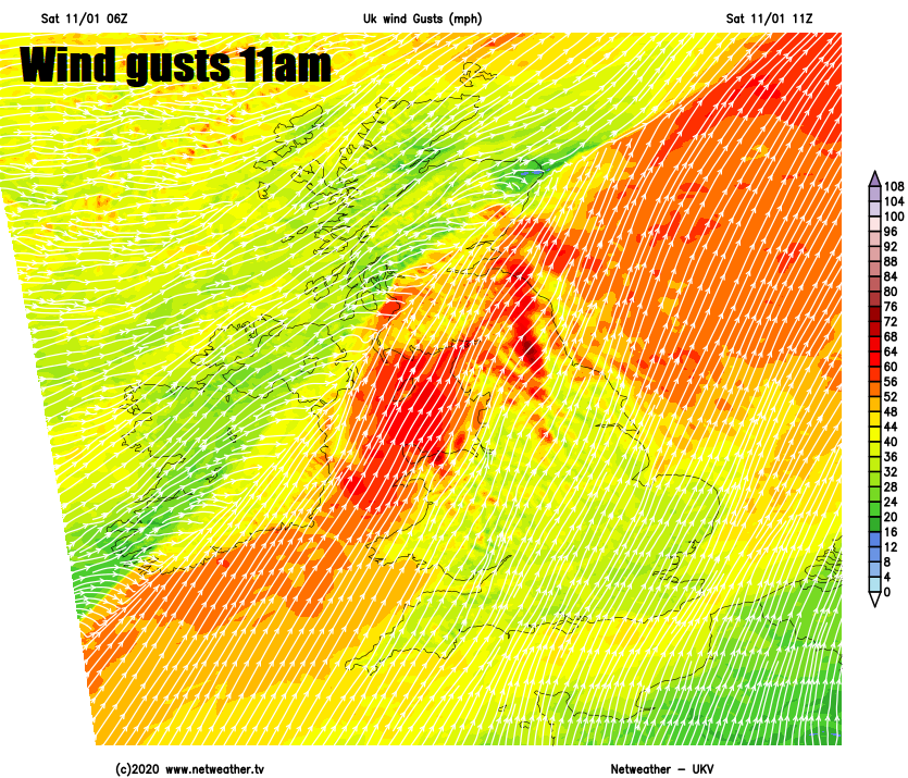
Gales with gusts of 50-70mph continuing this morning across southern and eastern Scotland and northern England, winds will ease into the afternoon across Scotland and N. Ireland, but remaining very windy across northern England, northern and western Wales – with gusts of 50-60mph over exposed coasts and hills. A mild day across the board, temperatures reaching 10-13C widely.
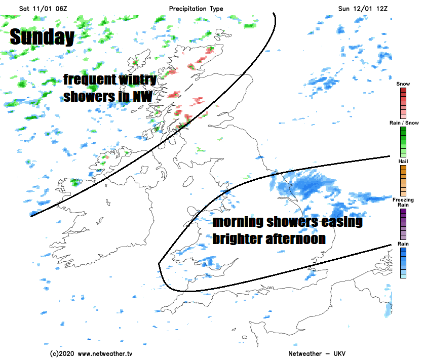
A band of rain and strong winds will sweep southeast across England and Wales tonight, reaching SE England and East Anglia in the early hours of Sunday. Generally south Wales and southern half of England cloud and windy and becoming wet overnight, but further north becoming drier and less windy with clear spells developing, but also some showers in the northwest and, with colder air filtering in, showers turning to snow over Scottish hills.
Overnight rain clears SE England and East Anglia first thing Sunday, but a crop of showers left behind across Wales, the Midlands and running into East Anglia with a few further south too for the morning, before these ease away in the afternoon to drier and brighter conditions. Scotland and N. Ireland seeing sunny spells, mostly dry away from western Scotland – where there’ll be wintry showers running in from the west, falling as snow over the hills. A colder day across northern Britain – with temperatures reaching 4-7C at best, southern Britain milder but not as mild as recent days, highs of 8-11C.
A deepening low pressure system out in the Atlantic will race northeast to the northwest of Britain on Monday, which will really strengthen the winds and bringing in some rain to the west by evening too. Most places will start the day dry and bright and remaining so across the east into the afternoon. But further west thickening cloud will spread in from the west, followed by rain moving in through the afternoon. But it will be the increasingly strong winds that will be of concern, with gusts reaching 60-70mph across western areas of the UK through the afternoon and evening, which may cause some disruption to travel and power supplies. Milder though, with temperatures reaching 8-11C.
Wet & windy at times next week as a strong jet stream fires deepening lows towards the UK
Very changeable and sometimes stormy for the rest of the week, with gales and heavy rain for many at times The jet stream will sink south to run across southern Britain, so further low pressure systems developing out in the Atlantic will likely track across Britain rather than to the north. Which means there will be a risk of gales or severe gales for southern areas too. One deepening low looks to cross central areas on Tuesday, which we are keeping a close-eye on, while another deepening low moving across Scotland Thursday night. So expect Met Office weather warnings for wind and rain to be issued for these over the next few days.