


After weeks of wet weather for many, the final days of 2019 look to be dry and mild, though there will be some rain for Scotland over the next few days. Could be a cold night though to see in 2020.
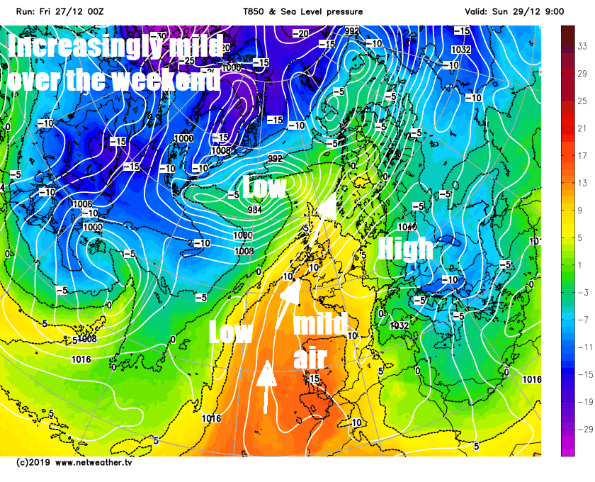
After the fine and sunny weather on Christmas Day, Boxing Day saw a duller and breezier day with outbreaks of rain affecting many areas. Scotland and N. Ireland will be often cloudy and breezy with rain at times today and over the weekend – thanks to lower pressure here and a wriggling weather front. But for much of England and Wales it will be largely dry with sunny spells by day, thanks to a large area of high pressure centred on the near continent extending its influence. However, a common theme across all of the UK and Ireland will be that it will become mild for the time of year.
It looks like the last two days of 2019 early next week will stay mostly dry, bar a few showers moving across the southwest Tuesday morning, with most looking to see in the New Year on a dry but cold and perhaps frosty night.
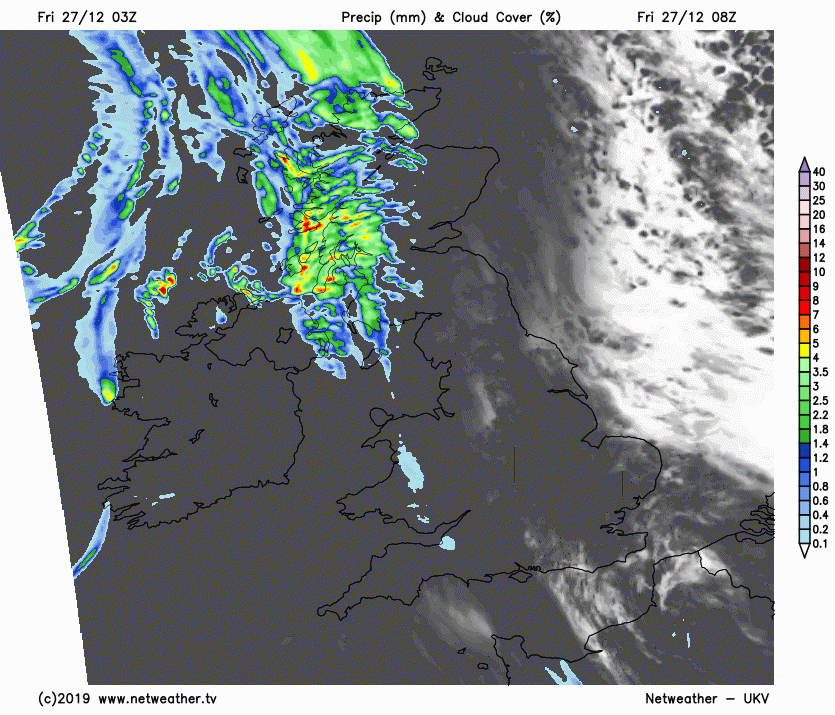
For now, a dry, in places bright and chilly start, locally cold enough across central parts under clear spells overnight to allow a touch of frost. However, it’s cloudier and milder across the far west and these milder and cloudier conditions will reach all parts through the day, as a warm front moves east. The cloud streaming northeast will be thick enough to bring outbreaks of rain across Northern Ireland and Scotland through the day, heavy over western hills, with patchy light rain or drizzle affecting NW England too. Otherwise the rest of England and Wales will stay mostly dry if rather cloudy, though perhaps some sunny spells across eastern England.
Quite a brisk southwesterly wind across Scotland and N. Ireland, lighter southerly wind across England and Wales. But turning milder everywhere through the day, temperatures highest in the west – where there’ll reach 10-12C, in the east reaching 7-10C.
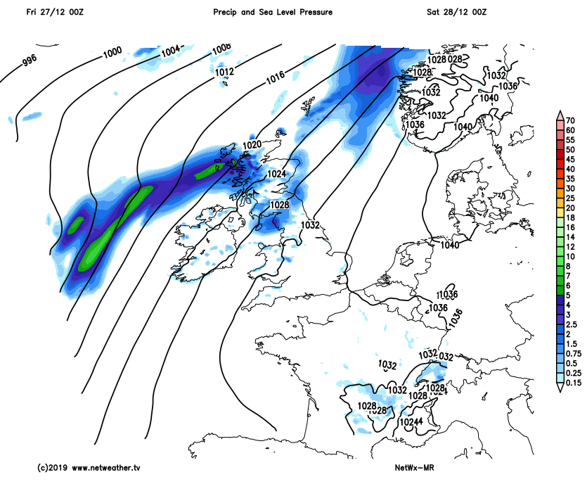
Mild but generally cloudy overnight, northern and western Scotland along with northern N. Ireland will see further outbreaks of rain and it will be windy here too, otherwise most places will have a dry night.
Saturday is looking like a dry day for most places, with variable amounts of cloud and some sunny spells. The exception will be across northern and western Scotland along with N. Ireland – with a wriggling weather front close to the northwest bringing thicker cloud and outbreaks of rain here and it will be windier here too. Mild everywhere, with most places reaching double figures, with temperatures ranging between 10-12C.
High pressure over the near continent will keep England & Wales mostly dry this weekend, but Scotland and N. Ireland prone to cloud and rain
A similar picture for Sunday, a weather front close to the far northwest will bring thicker cloud and outbreaks of rain to northern and western Scotland, but for the rest of Britain it will be mostly dry with variable amounts of cloud and maybe more in the way of sunshine than Saturday. Mild for most, perhaps very mild in the north and west, temperatures reaching 10-11C across southern, central and eastern areas, while northern and western areas we could see temperatures as high as 12-14C, perhaps higher in the lee of high ground (Foehn effect).
Monday’s looking largely dry and sunny again across England and Wales, cloudier across Scotland with a weather front drifting north taking a band of rain with it. Not quite as mild as the weekend, temperatures back down to around average for the time of year, 7-9C generally, perhaps 10-11C in the far west.
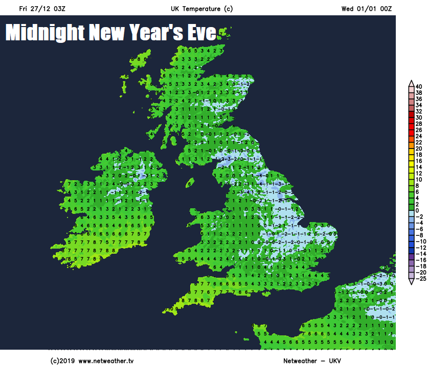
New Year’s Eve could see a few showers across SW England in the morning, otherwise it’s looking mostly dry with increasing amounts of sunshine spreading down from the north after perhaps a cloudy start with mist and fog in places. As we head towards midnight, we could see clear skies across many parts – which will mean it will turn cold and locally frosty as we see in the New Year.
The first few days of 2020 may see high pressure across the south to begin with start to retreat over the near continent, allowing more unsettled, milder and windier conditions with rain at times to take over across the north towards the end of the week after a dry mid-week, the south perhaps staying dry until the end of the week.


