Analysis of the potential for the recent protracted hot and dry weather to come to end next week
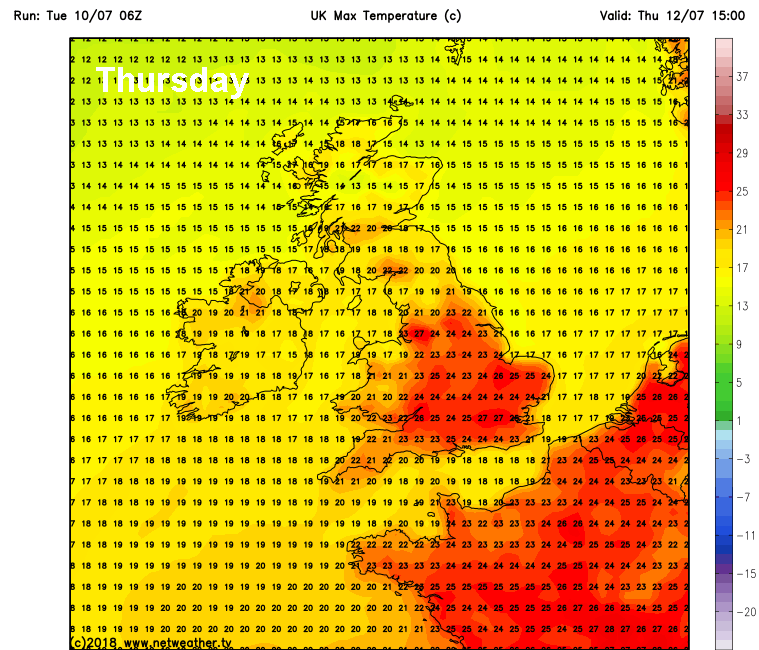
It has turned cooler and fresher across all parts overnight following a weak cold front sweeping south, following several days of heat and humidity across southern areas in particular. However, the northerly flow bringing the cooler airmass will ease as we head towards the end of the week, this will allow the heat to rebuild across southern Britain from Thursday, with temperatures back into the mid to high 20s Celsius, Saturday perhaps the hottest day.
Heat returns to the south later this week, but for how long?
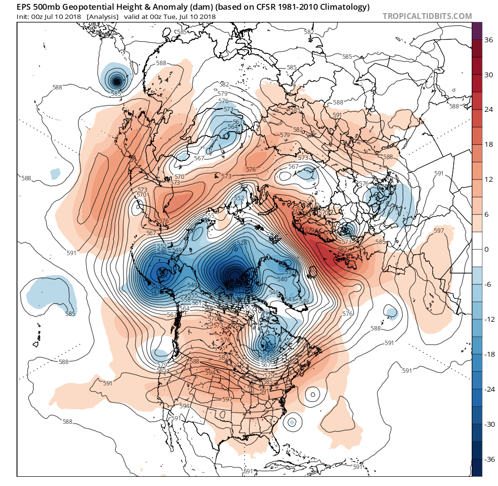
But, if you have had enough of the heat, there may be some good news on the horizon. The stubborn high pressure ridging which has brought the very dry and often hot conditions since May looks like breakdown into next week, albeit perhaps briefly, with cooler and more unsettled Atlantic westerlies or southwesterlies taking over through next week. We haven't really Atlantic westerlies dominate since way back in January, before the infamous Stratospheric Warming in February led to the severe cold spells in March and affected the upper patterns throughout Spring and probably the start of summer, by bringing a lot of blocking high pressure in the mid to high latitudes this side of the northern hemisphere.
00z ECMWF ensemble mean earlier today suggest the blocking retreating to allow troughing to move in = breakdown to more unsettled weather:
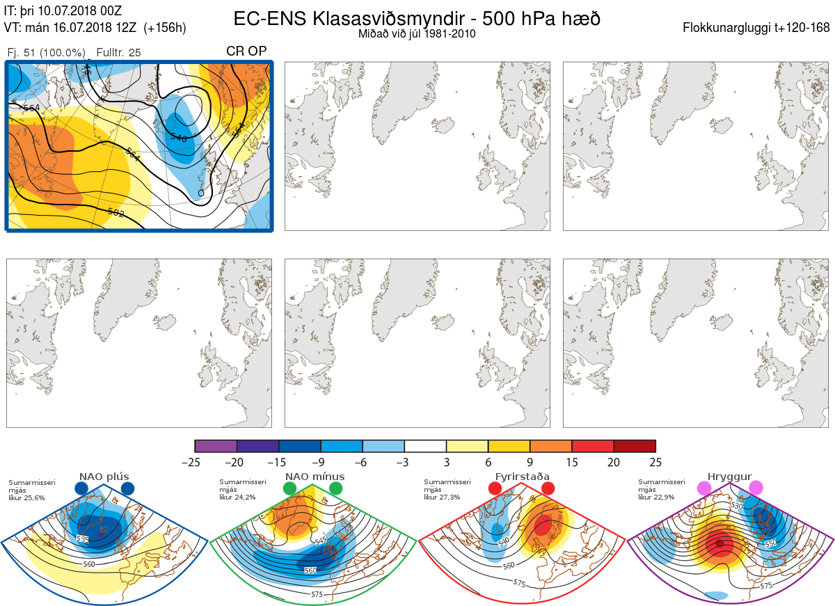
Lack of clusters in the ECMWF ensembles early next week suggests confidence in troughing close to the west too
The coming change away from blocking is perhaps due to a few factors combining, the two main drivers perhaps are:
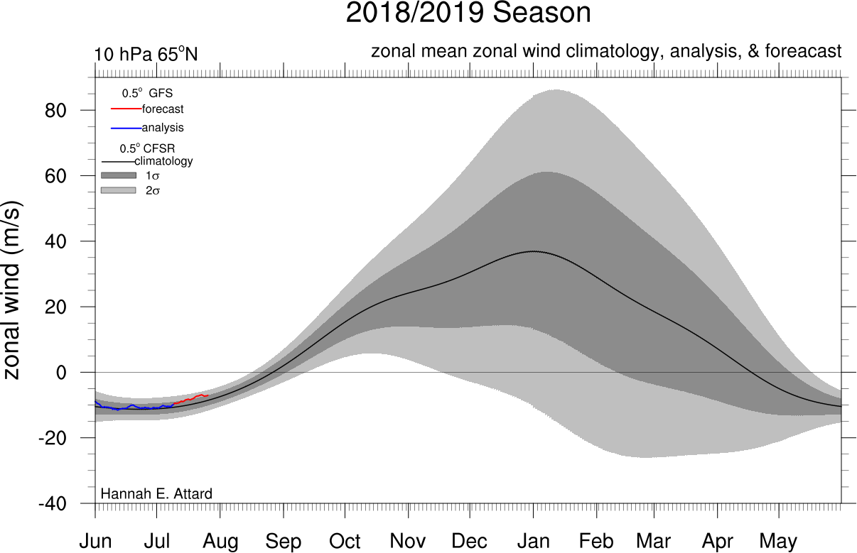
1. Easterly winds over the polar stratosphere, which tend to favour blocking over northern Europe, are weakening, with a slow transition to polar stratospheric winds becoming westerly. This, in turn, allowing westerlies into the troposphere (where our winds occur) to gain momentum while the recent blocking relaxes its grip, this will allow the upper westerly flow or jet stream to strengthen and push south across the Atlantic closer to the UK as we head into next week, the jet recently being way to the north of the UK and weaker with high pressure blocking in control over northern Europe.
Stratospheric winds, which are currently negative zonal (easterly) are forecast to turn neutral, this is before the climatic average return to neutral then westerly in late August.
2. Tropical Storm Chris off the eastern seaboard of the U.S. is forecast to become a Hurricane in the next 24 hours before becoming extra-tropical on Friday and eventually picked up by the strengthening westerlies / jet stream sinking south over N America and the North Atlantic - this will add extra energy (heat and moisture) to the baroclinic zone (zone which separates polar air from tropical air in mid-latitudes) and thus strengthen the jet stream downstream towards the UK too.
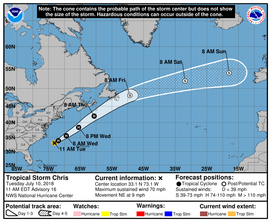
The extra-tropical remnants of Chris will be picked up by an upper trough emerging east out of Canada over the North Atlantic and looks to pushed by the trough moving east and carried along the jet stream over the Atlantic this weekend as an Atlantic depression, though there is quite a bit of uncertainty from the models over where the remnants of Chris will head, some models like GFS to the NW of Britain, some to the south of Ireland. However, the remnant depression formerly TS/Hurricane Chris will serve to deepen the upper trough, thus pulling south the jet stream and ramping up the jet by injecting warmth and moisture along the baroclinic zone.
06z GFS: watch Chris emerge off New Foundland to the left before heading toward the UK on the jet stream for the weekend.
This could bring an unsettled breakdown towards NW Britain initially this weekend, bringing stronger winds and some rain. These more unsettled conditions then perhaps spreading further east across the rest of Britain early next week, as the jet stream shifts south and an upper trough moves in close to the west, bringing frontal systems across the UK rather than just the far north, bringing a chance of some much-needed rain and lower temperatures. Though there is still a risk of heat and humidity returning to the southeast.
06z GEFS 'postage stamps' for rainfall suggest the chance of rain across many parts early next week, this chart for noon Monday
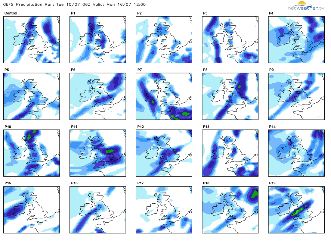
However, rainfall amounts may be less and unreliable across the south, as rain most likely to fall in the form of thundery showers, more persistent and widespread rainfall most likely the further north and west one is. A great deal of uncertainty for next week from model guidance on detail and rainfall amounts, but certainly looks like the recent blocking and prolonged settled and dry weather may be on the way out.