Further cool and cyclonic conditions are forecast within the short term, but then perhaps with some longer term changes.
Issued at 1500BST on Tue 12th Sep based on Tue 12th Sep 00Z Model Runs
Key Points
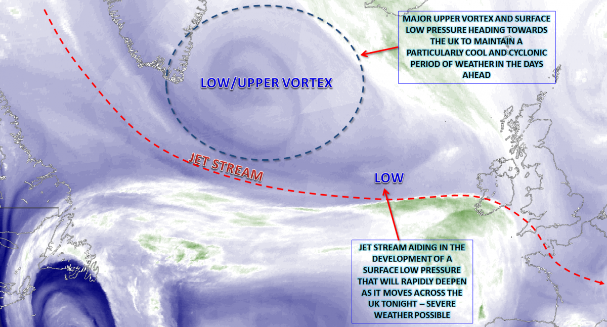
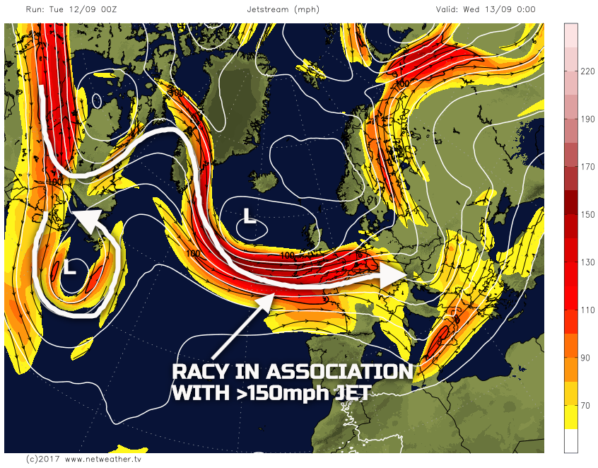
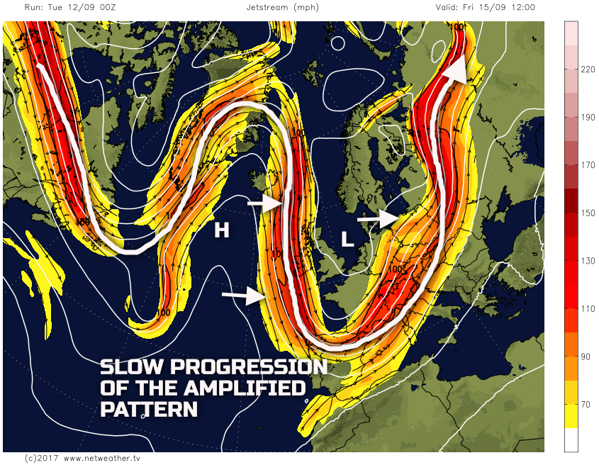
Into Wednesday and the main feature of interest will be the development of a surface low pressure as it moves across parts of the British Isles through Tuesday night and on into Wednesday. A large upper vortex, associated with a strong jet stream, will be aiding in the development of the surface low pressure overnight tonight. Even at this stage, there are uncertainties over the track and depth of the low pressure regarding how quickly the surface low will become located on the ‘cold side’ (diffluent, left exit region) of the jet stream. The overall pattern though is highlighted well by the GFS tonight, with a particularly autumnal looking 300mb pattern.
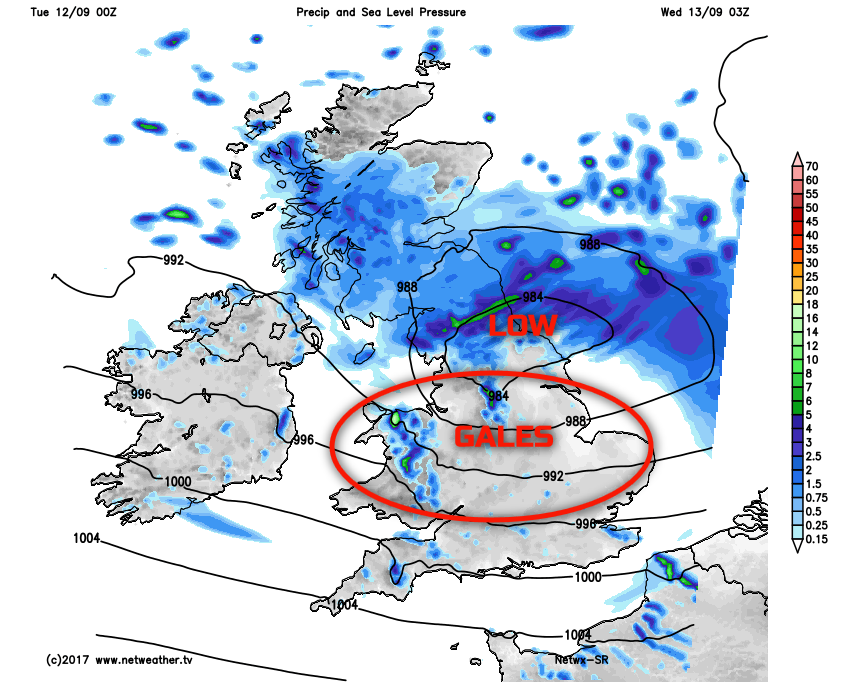
Through into early Wednesday and persistent and heavy rain is expected in association with the low pressure moving across the British Isles. Significant rainfall totals across parts of Scotland and N England may well lead to some temporary surface water flooding through into the early hours of Wednesday and bring poor driving conditions on Wednesday morning. However, it is the strength of the wind, immediately on the S and SW flank of the developing low-pressure, that is of primary concern. Parts of Wales, southern areas of N England, Midlands and E England may well see wind gusts more than 60mph early on Wednesday, locally higher perhaps too. Some slight structural damage is possible, and with trees still in full leaf, then some felled trees are possible too. The overall combination of heavy rain and some extreme winds does mean that some travel disruption is possible, in places, first thing on Wednesday morning.
The low pressure will quickly clear away to the E of the UK through Wednesday though, driven along by the powerful jet aloft. Following across many areas through the afternoon will be further blustery showers. Forecast models from the UKMO, GFS, GEM, ECWFM and the HRES models all indicate unusually cold upper-level temperatures, 500mb temperatures, for example, down to -24C. As a result, some heavy showers, perhaps with hail and thunder are likely almost anywhere through Wednesday afternoon, and it will be a noticeably chilly day too.
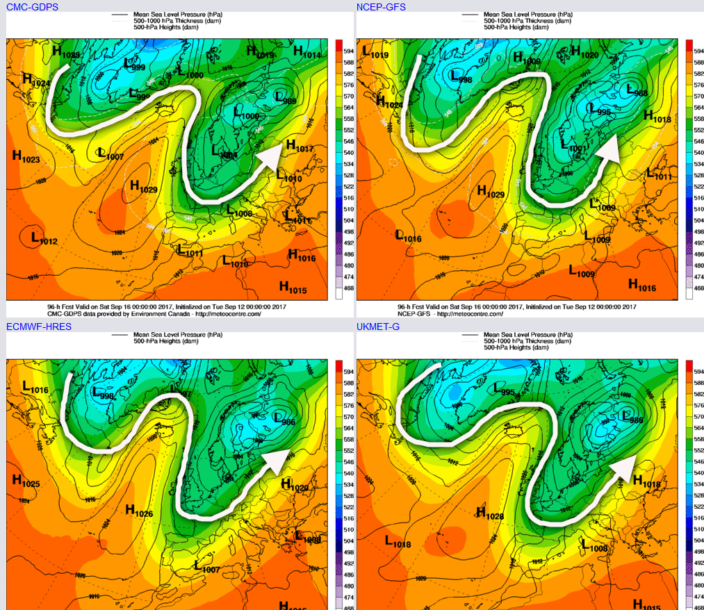
Thu 14th Sep: Thursday will see the upper vortex drift down into the UK, while a more amplified pattern begins to develop across the N Atlantic. As Thursday progresses, there will be a distinct meridional pattern between E Canada and the USA. Unfortunately for the UK, we will be located at the base of the upper trough, on the eastern flank of the building ridge within the N Atlantic, as exampled by the 00Z GFS.
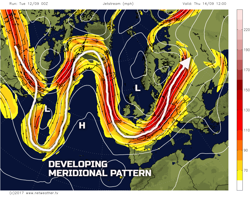
This developing meridional pattern will have implications on the weather further into the coming weekend. However, for Thursday itself the UK will be beneath a cold pool, a thermal trough, so another day of sunshine and showers are forecast across many areas. A frontal zone may well bring some longer spells of rain to E England and E Anglia for a time too, but this clearing away. The distribution of the showers will be directly related to an N or NW’ly flow. As a result, some inland areas of S Scotland, N England, Midlands and S England may well see quite a lot of dry weather, with some sunny spells too. However, areas exposed to the N or NW’ly wind will see some frequent heavy, showers and with indeed a risk of thunder at times too.
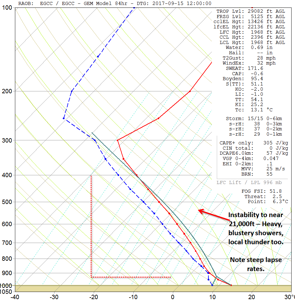
The forecast sounding for Manchester, for example, on Friday afternoon highlights the overall atmospheric profile well. Steep lapse rates in evidence, note how the dew point (blue dashed line) and environmental temperature line (solid red line) quickly decline away, indicating marked CAA within the mid and upper levels of the atmosphere. The forecast sounding shows an entirely unstable profile to near 21,000ft, even with modest surface temperatures. As a result, heavy showers and local thunderstorms are indeed possible.
Fri 15th Sep: We end the working week with the overall pattern across the British Isles and NW Europe very similar to that of Thursday. The main long wave upper trough will still be over the British Isles through the day, and this will maintain a convective regime. Wind directions, by Friday, are forecast to be N’ly across many areas so that it will be a distinctly chilly end to the week and with an increased risk of some cold nights as well, particularly when decoupling occurs overnight in more sheltered areas. The meridional pattern across the N Atlantic will slowly progress mind and, as a result, some influence from the approaching ridge from the W is likely as the day progresses, with more western areas potentially seeing fewer, or at least light showers, later in the day.
The forecast soundings through the day are very similar to that of Thursday, so, again, some heavy and thundery downpours are certainly possible but these perhaps most likely across central and eastern areas of England and Scotland, beneath the main long wave upper trough. We are still at a time of year when diurnal heating of the surface, across inland areas, will be enough to promote convective development, so while sea-based convection is forecast, showers will develop still inland through the day as well, but then potentially easing back to coastal areas later in the day.
Sat 16th and Sun 17th Sep: Into the weekend and there is good agreement between the 00Z UKMO, GFS, GEM and ECMWF. However, the primary issue is just how quickly the upper trough declines to the E and how quickly the ridge from the W approaches. It would seem, at the moment at least, that the upper trough will still have enough influence over the weather across England and Wales on Saturday to maintain a risk of locally heavy and perhaps thundery showers here. A very similar convective regime is forecast, on Saturday, across England and Wales when compared with Thursday and Friday. However, across Scotland and Ireland, the approaching anticyclonic conditions will likely mean fewer, lighter showers and perhaps a mainly dry end to Saturday.
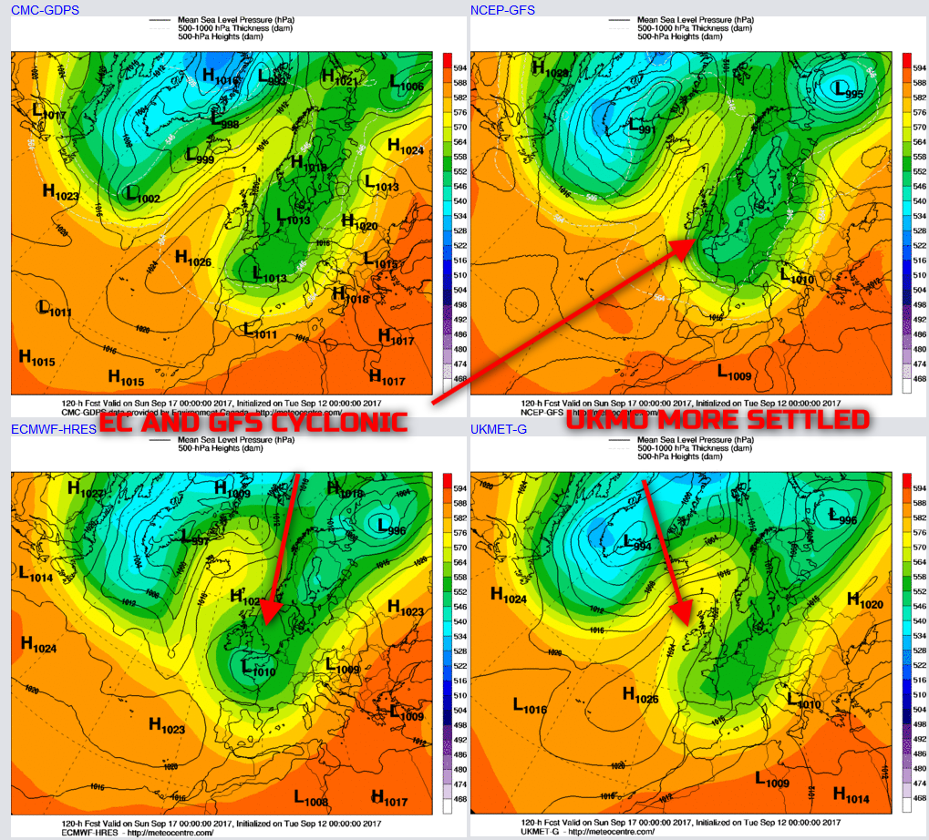
By Sunday and differences in the model, outputs do become more pronounced, especially when analysing, for example, the EC Clusters, with quite a distinct split, regards the overall pattern across the British Isles and NW Europe. For example, as we move into Sunday 17th, the 00Z UKMO model more significant clears the upper trough away and with more in the way of an anticyclonic pattern developing across most areas. However, the GFS and the ECMWF, in particular, maintain a far more cyclonic pattern. If these models do come to fruition, then the risk of showers would be retained across many areas into Sunday too, but especially across England and Wales.
With a rather cold air mass in place, when coupled with lighter winds, the increasingly long nights and clear skies, then a more widespread risk of ground frost is certainly possible, with some particularly chilly nights.
Medium and Longer Term 18th Sep onwards:
Looking further ahead and, in recent days, there has been a signal for a more pronounced settled spell of weather. However, as has been the case throughout the summer months, this longer term signal for higher pressure is now dwindling, albeit with little confidence. There is now a far more distinct split within the medium and longer term, with regards to a potential settled spell into early next week (18th and 19th), but with then an erratic transition towards more unsettled conditions towards the latter stages of September. We’ll keep a close eye on this development in the next few days and discuss in further detail as the further model runs become available.