


Thundery showers spreading southeast today. After a bright start in the east, spell of wind and rain in the west spreading across all parts on Sunday. Remaining unsettled and cool throughout next week too.

A cool and unsettled weekend is in store for all, thanks to two areas of low pressure. The first low this weekend, that crossed Scotland yesterday, is now moving out over the North Sea – but it will pull in a cool and showery northwesterly flow. Sunday sees a new low, deeper this time, approaching northwest Scotland – which will bring a spell of rain followed by strong winds and showers. The cool and unsettled theme continues next week too, with a rinse and repeat of sunshine and blustery showers early in the week, before another Atlantic depression moves in later on Tuesday bringing wind and rain, followed by a cool and showery northwesterly flow for the rest of the week.
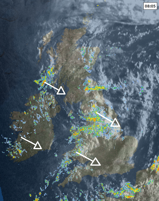
For now, it’s a cool and breezy start to the weekend and there are showers from the word go across northern and western areas, especially frequent and heavy across northern England and west Wales. The Midlands, East Anglia and southern England away from the far southwest will see some drier and sunnier weather this morning. Showers, which will continue across the north and west in to the afternoon, will spread southeast, eventually reaching southeast England late afternoon and early evening – where they will be slow-moving. Showers anywhere will be heavy locally, with a risk of hail and thunder developing, especially across England and Wales. Showers perhaps fading across southern and eastern Scotland and N. Ireland through the afternoon.
Showers in the north and west spreading SE through the day ...
Temperatures today disappointing for the time of year, thanks to the cool northwesterly flow, reaching 15-18C generally, perhaps 19C across SE England, though feeling pleasant enough in any sunny spells.
Showers will tend to die away across most areas overnight, as a brief ridge of high pressure builds in from the west, clearing skies will mean it will turn chilly, with mist and fog patches perhaps forming across eastern parts. Cloud and rain with a strengthening southwesterly wind arriving across N. Ireland, northern and western Scotland by dawn.
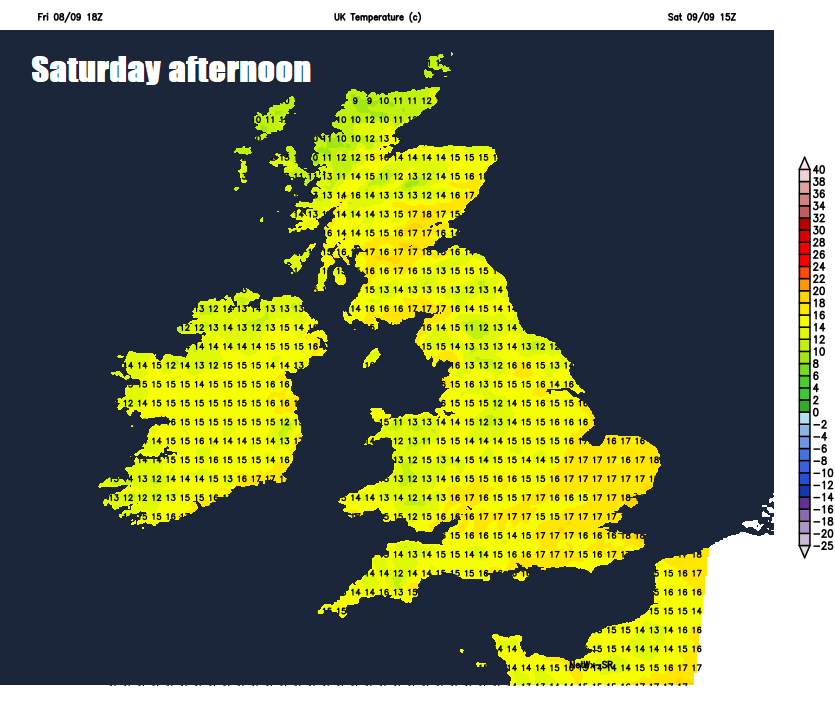
A deep area of low pressure approaching NW Scotland will spread outbreaks of rain and strong winds across Scotland, northern England, Wales and SW England during the morning, sunshine and showers following across N. Ireland by late morning. Central and eastern areas of England starting off dry, sunny and chilly, with some mist and fog patches in places. Sunshine will be become confined to the far southeast of England in the afternoon, as a spell of rain and gusty winds continues to spread east across the UK and reaches here early evening. Sunshine and blustery showers following across western areas through the afternoon and into early evening, heavy in places with hail and thunder with the westerly wind becoming increasingly strong, with gales across western coasts. Temperatures reaching 13-16C in the north, 16-19C in the south.
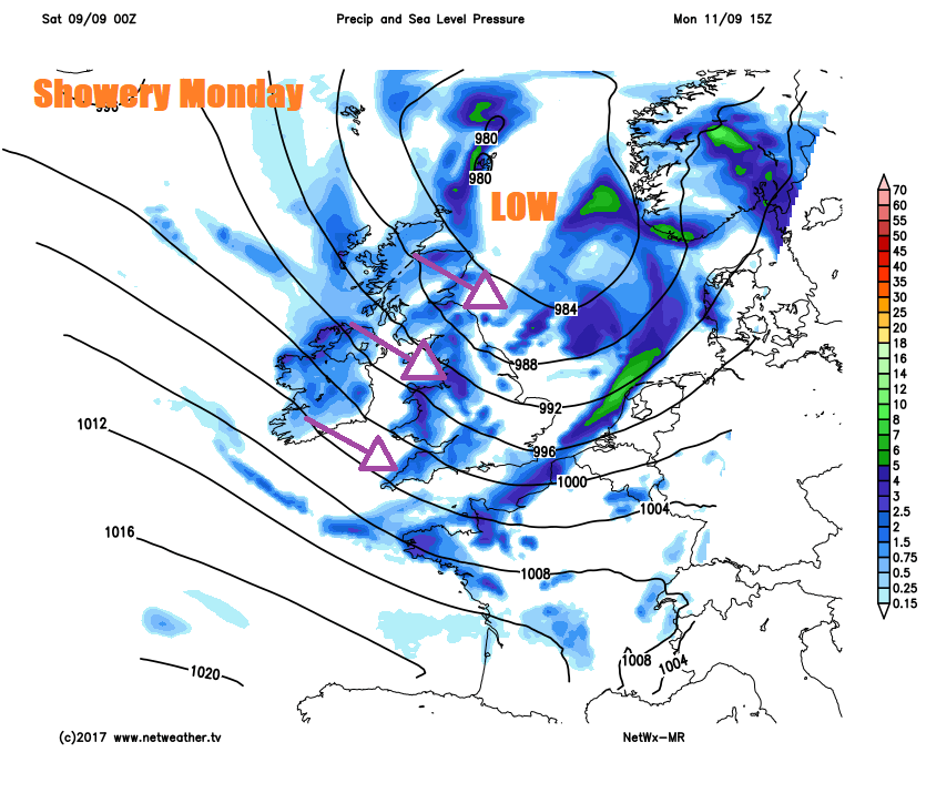
Low pressure is still well and truly in charge to start next week, centred close to the Northern Isles on Monday and with tightly-packed isobars it will be rather windy, with gales or even severe gales across the southwest. The strong northwesterly wind driving through plenty of showers across all parts, which will be locally heavy and thundery. Temperatures ranging from 15C in the north to 19C in the southeast.
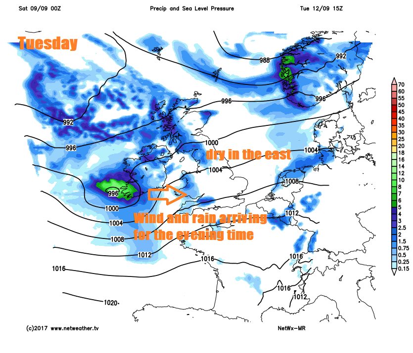
A mostly dry and bright day for many on Tuesday, though showers dotted around coastal areas perhaps, before heavy rain and strong winds arriving across Ireland in the afternoon spreads east across England and Wales in the evening.
Overnight rain quickly clearing eastern England to sunshine and blustery showers on Wednesday, locally heavy with hail and thunder. A cool northwesterly veering northerly flow on Thursday and Friday, bringing sunshine and scattered showers, showers tending to fade overnight and with clearing skies turning chilly with a risk of ground frost in the north.


