A cool end to the week and over the weekend, with blustery showers today and Saturday. Wet and windy weather sweeping east on Sunday.
Low pressure is close by northern Britain to end the week, so for most it will be a cool day of blustery showers and some bright spells. Sunshine and showers will be the order of the day on Saturday too. Then on Sunday another, this time deeper, Atlantic depression will bring a spell of wet and windy weather sweeping across all areas, followed by blustery showers, with gales likely, especially later in the day. So all-in-all, a cool and unsettled picture as we head through the weekend. Next week looks to remain cool and changeable too, with another deep low crossing northern Britain mid-week, bringing wet and windy conditions followed by a cool and showery northerly flow for the rest of the week.
The Atlantic in the northern hemisphere is certainly bringing some disturbed weather, no more so than in the tropical Atlantic, with three Hurricanes on the go. Hurricane Irma is currently pummelling low-lying Caribbean Islands before grazing the north of Cuba later today and through Saturday, then swinging more north to make landfall across Florida on Sunday. Given that Irma is wider than the length of the State of Florida, obviously there is potential for major and life-threatening impacts. Behind Irma, another storm, Jose, was upgraded to a major category three hurricane last night, with 120 mph winds. It is expected to strengthen slightly before impacting Antigua and Barbuda that have already been devastated by Irma, though Jose should swing away north toward Bermuda before impacting further east. There is a third hurricane east of Irma over the Gulf of Mexico, Katia, which is a category one storm with 85 mph winds and is expected to make landfall across the Mexican state of Veracruz.
Track of Irma over coming days ...
Three hurricanes on the go ...
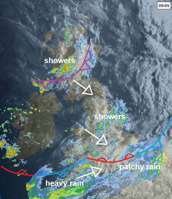
Back to a less threatening but still unsettled UK, we have the centre of a low pressure system crossing northern Scotland, so today will be a windier day, than Thursday. Much of southern England staying cloudy for most of the day, with outbreaks of rain, as waving cold front is slow to clear. Some of this rain will be heavy and perhaps thundery towards SW England this morning and then further east along southern counties this afternoon, perhaps turning brighter and showery across SW England into the afternoon though. Further north, it will be more showery, with some bright or sunny spells between the showers – which will be locally heavy with hail and thunder.
Temperatures rather disappointing for early September, reaching 15-18C generally, perhaps 19C across SE England and East Anglia.
.png)
Heavy outbreaks of rain, perhaps thundery, across southeast England this evening should eventually clear to join many southern, central and eastern areas to dry night with clear spells. Showers continuing across northern and western areas though and it will remain windy towards western coasts.
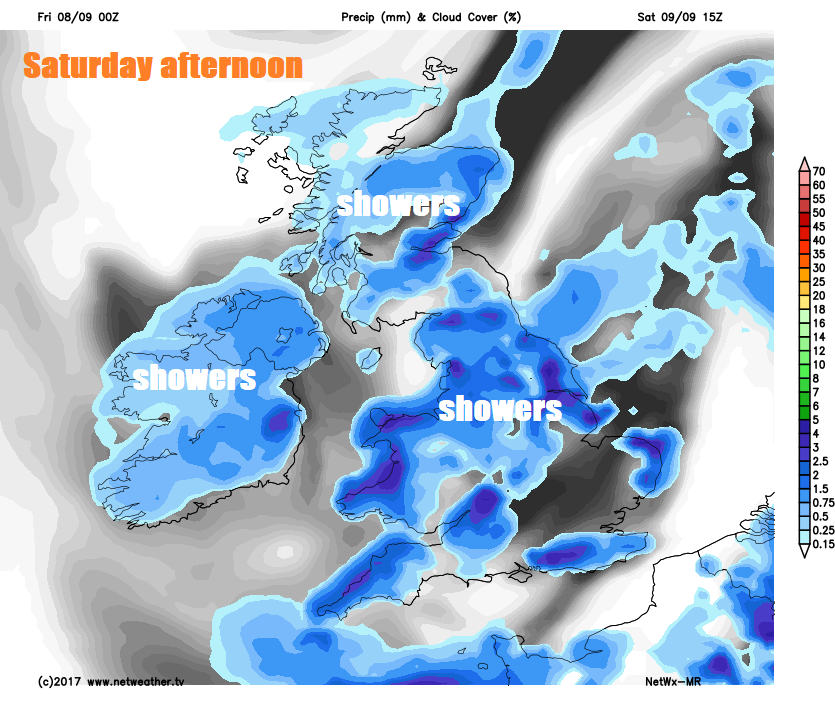
As today’s low pressure near Scotland pulls away across the North Sea to start the weekend, it will draw down a cool and showery northerly flow across Britain on Saturday. Most of the showers will be across northern and western areas during the day though, where they will be locally heavy with hail and thunder, while eastern England may stay mostly dry and sunny. Though showers in the west will probably move towards the east by the evening. Temperatures reaching 14-17C in the north, 16-17C in the south.
Another deep area of low pressure arrives off the Atlantic on Sunday, the centre of the low crossing northern Scotland Sunday evening. So, after a promisingly dry and bright start across England and Wales, a spell of rain already arriving across Scotland. Republic of Ireland and N. Ireland first thing will sweep southeast across all parts during the day before clearing southeast England in the evening. Sunshine and blustery showers following the band of rain moving southeast and everywhere will become increasingly windy, with gales developing around western and southern coasts. Temperatures reaching 13-15C in the north, 16-19C in the south.
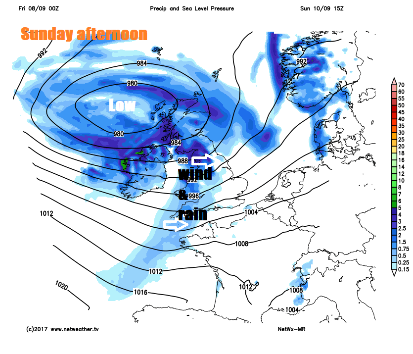
Sunday night could be very windy with gales around southern and western coasts or even severe gales towards the southwest for a time. Strongest winds then easing eastwards on Monday, though still a blustery day with a strong northwesterly flow driving showers through most areas through the day and it will be on the cool side with temperatures ranging from 15C at best in the north to 19C at best in the south.
A ridge of high pressure tries to build in early Tuesday, as low pressure pulls away eastwards, so drier and more settled for a time, though still on the cool side with a northwesterly breeze. Perhaps some showers still down eastern coasts and during the afternoon we could see wet and windy weather return across Ireland, Wales and SW England, heralding another area of low pressure arriving off the Atlantic, though some uncertainty how quickly this will arrive. A deep low looks to cross northern Britain on Wednesday, tracking and timing still not certain, but expect a wet and windy day. A cool northerly wind bringing sunshine and blustery showers on Thursday and Friday, as Wednesday’s low pressure systems clears eastwards and high pressure builds north to the west of Britain.