


A day of sunshine & showers for Thursday, locally heavy with hail & thunder. Fewer showers on Friday, then a fine first half to the weekend, before rain arrives in the west Sunday.

We are into to the last day of meteorological summer, however yesterday across the southeast it felt like late autumn, with temperatures no higher than 13C in a few spots which the day before were recording 29C!
Today should feel warmer for all, with some sunshine on offer, but showers will develop widely from the west. Fewer showers on Friday, then the first half of the weekend looks promising, as ridge of high pressure brings a fine day on Saturday. But Sunday probably seeing an east-west split, with cloud and rain arriving in the west, while the east hangs on to dry and bright weather.
For now, clear skies overnight and a cool but light westerly flow have meant temperatures have widely plummeted into single figures across rural parts away from western coasts. Temperatures dropped to 3-4C across southern Scotland and north of England, bringing a slight frost, and 5C as far south as Oxfordshire. So, it’s a bright, but nippy and autumnal feel out there first thing.
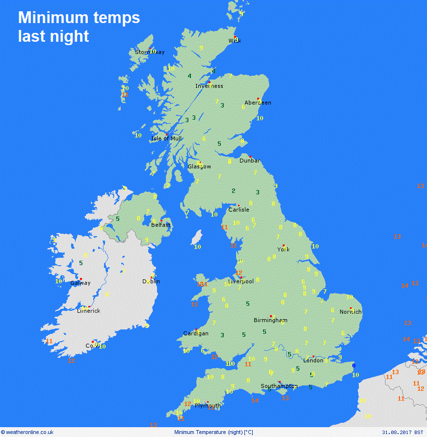
Credit: Weatheronline
It’s a different story for western coasts though, where the westerly flow off relatively warm sea temperatures are bringing balmier temperatures in the low teens to start the day, but also some heavy thundery downpours from the word go, especially across NW England and Wales – where some may have been woken up by thunder.
These thundery showers towards western coasts will spread east and develop more widely across many areas through the day after a dry and sunny start across many areas. Showers will be heavy locally and will be slow-moving, with the odd rumble of thunder and perhaps bringing some hail too. Feeling pleasant in the sunshine in between the showers, thanks to light winds, temperatures reaching 14-15C across northern Scotland, 16-19C generally further south, perhaps 20C in London.
Showers will tend to fade away as we go into Thursday night, leaving many areas dry with clear spells, which will mean it will turn chilly again overnight, with temperatures falling as low as 1-3C across sheltered valleys in Scotland and northern England, perhaps bringing a ground frost. Also, some mist or fog patches forming too in places.
So, another nippy and fresh start for Friday, then for many it may stay a dry day with a good deal of sunshine. The cloud will bubble to bring some showers in places though, but fewer than today and mainly across the Midlands, eastern England and parts of eastern Scotland. Temperatures reaching 15-18C in the north, 18-21C in the south.
High pressure builds in from the southwest on Saturday, so a largely dry and fine day for most, with some good sunny spells, with temperatures reaching 15-19C generally, perhaps 20-21C across SE Britain.
Saturday's looking mostly fine, cloud and rain moving into the west on Sunday, eastern England dry
Cloud and outbreaks of rain moving in across northern and western areas through the day on Sunday, but perhaps not reaching eastern parts of England, a freshening southerly breeze across most areas, temperatures generally in the mid-to-high teens.
A quick look at early next week and Monday, for now is looking rather cloudy but humid with some patchy rain around. Tuesday looking mostly dry and bright or sunny. Then after perhaps a dry and bright start, rain, perhaps thundery, moving in from the west as low pressure over the Atlantic moves closer.


