Cooler and fresher conditions across central and northern areas, showers in the NW. Still very warm and sunny in the SE. Cooler with rain in the south tomorrow, otherwise sunshine & showers for rest of the week.
On Monday, we saw the warmest late August Bank Holiday on record, as the top temperature of 28.2C in Holbeach in Lincolnshire yesterday trumped the previous record of 27.2C in 1984. Much of England and Wales enjoyed some very warm late August sunshine yesterday, but it was a cooler and cloudier picture further north across Scotland and N. Ireland – with outbreaks of rain.
These cooler conditions are slowly spreading down across England and Wales today, behind a weak cold front, though the heat and humidity will hang on across SE England. Cloud and rain will arrive across southern areas of England and Wales on Wednesday, before clearing early Thursday, otherwise it’s a story of sunshine and showers tomorrow, Thursday and Friday. The weekend looks like offering something drier, sunnier and more settled for many, though cloud and rain may arrive in the west on Sunday.
For now, for many it’s a dry and bright or sunny start to Tuesday, though there is a band of cloud across Wales and northern England edging slowly southeast towards the Midlands and East Anglia this morning, marking a cold front, which will bring some patchy light rain in places. To the north of this front cooler and fresher conditions for Scotland and blustery with some showers towards the northwest this morning. To the south, a warm and muggy start across southern and southeast England, mostly sunny this morning, though mid-level cloud may bubble up to bring isolated sharp showers.
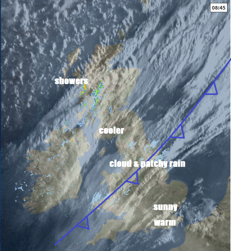
Into the afternoon, brighter, fresher and cooler conditions across Scotland this morning edging down across northern England and Wales too, though a risk of showers across Scotland and N. Ireland – where it will be windy too, especially towards the northwest. A narrowing band of cloud along a weak cold front, with little rain on it, arriving across SW England, Midlands and northern half of East Anglia. Across southeast England, sunny and very warm, perhaps hot in Kent, outside chance of a heavy shower.
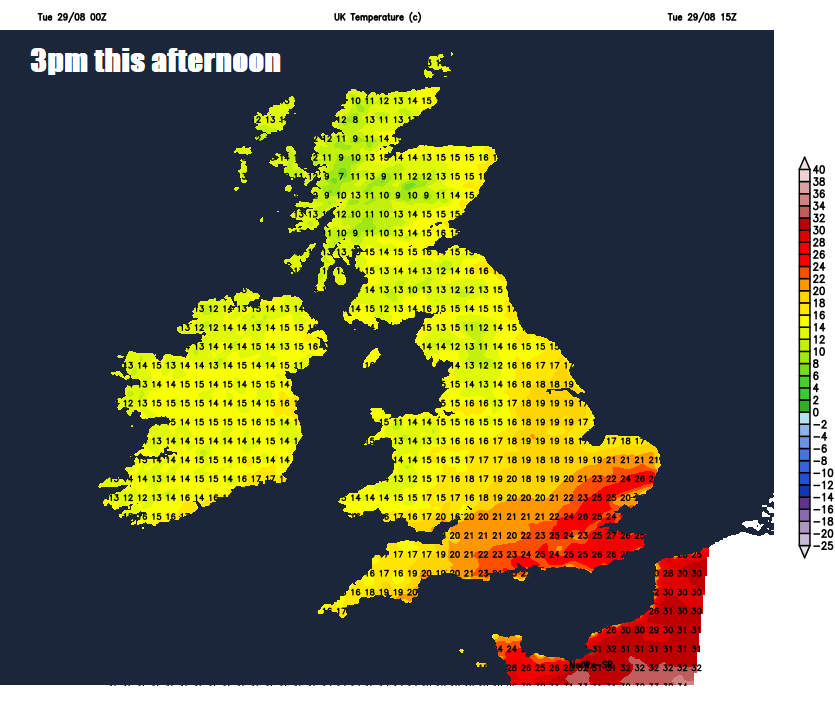
Temperatures this afternoon reaching a sticky 24-26C across central southern and southeast England to the south of the cold front, perhaps 28C in Kent. Under the band of cloud along the cold front and to the north, temperatures reaching a much cooler 17-20C across SW England, Wales, Midlands and northern England; 15-17C across Scotland and N. Ireland.
Showers continuing across western Scotland and perhaps north coast of N. Ireland tonight, otherwise cloud and rain will arrive across south Wales, central and southern England, perhaps thundery across the far southeast. Northern England and eastern Scotland staying mostly dry with clear spells.
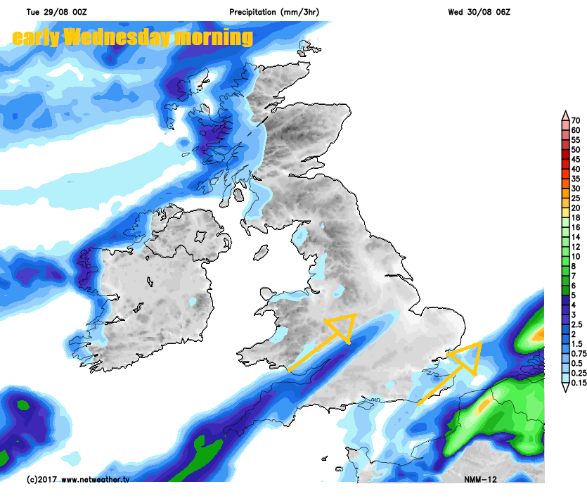
A cloudy and cool day across Wales, central and southern England, two areas of rain – with one affecting SW England, Wales and into the Midlands, the other across SE England and East Anglia, which maybe thundery at first across the far southeast. Drier and sunnier for northern England, but Scotland and N. Ireland will see a day of sunshine and showers, some of which maybe heavy and thundery. Temperatures reaching 15-17C widely, so much cooler across the south of England, where there will be northerly wind too.
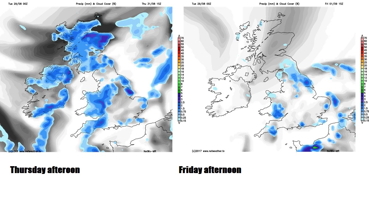
We stick with cooler and fresher feel for the rest of the week. Thursday will be a day of sunshine and showers, which will be heavy with thunder locally. Fewer showers on Friday, these mostly developing across southern and eastern England, where they could be locally heavy. Temperatures both days reaching 16-19C generally, perhaps 20-21C across SE England and East Anglia.
A fine first half of the weekend in store for most, as a ridge of high pressure builds in from the southwest on Saturday to bring dry and sunny conditions. The ridge collapsing southeast on Sunday, which may allow cloud, outbreaks of rain and strengthening winds to spread into the west through the day, though eastern areas remaining dry and sunny.