Low pressure and further cyclonic developments set to maintain a risk of rain and showers in the coming days.
Issued at 1500BST on Tue 22nd Aug based on Tue 22nd Aug 00Z Model Runs
Key Points
Discussion:
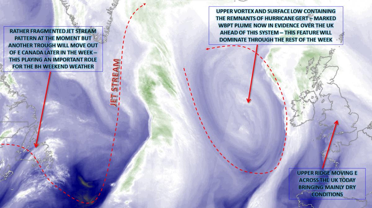
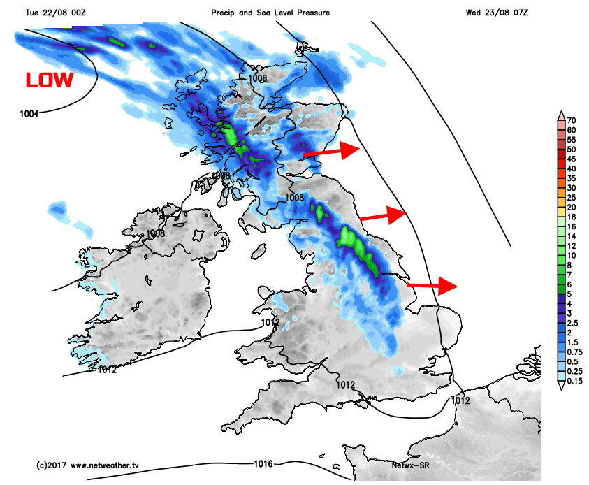
Wed 23rd Aug: Overnight and into Wednesday and the primary feature of interest will be the eastward movement of an upper vortex, associated with a low-pressure surface system that contains the remnants of Hurricane Gert. This system, in previous days, has allowed for a pronounced WBPT plume to spread N across much of the British Isles, in association with a Tm SW’ly air flow. As the upper vortex moves into the British Isles overnight and into early Wednesday it will aid to destabilise the air mass, while also bringing more dynamic frontal rain. As a result, it is forecast to be a wet start across northern areas in particular. This vortex is highlighted well, into Wednesday, by the 00Z GFS model.
Much of the interaction of the WBPT plume, along with the frontal zones associated with the low, will occur across northern regions. As a result, it is across Scotland and perhaps the far N of England, where a very wet start to Wednesday is forecast. Outbreaks of heavy rain, along with embedded downpours and thunderstorms, are certainly possible. Some poor driving conditions are likely for the morning rush hour period, with perhaps some temporary surface water flooding too. However, across much of central and southern areas of England, the connection between the surface fronts, a cold front, moving E and the WBPT is insignificant, and nothing more than a band of cloud is forecast. However, and importantly, despite this lack of activity across much of England and Wales on the cold front, it will introduce a much cooler and fresher air mass from the W through the day, with the primary WBPT plume clearing E.
Thu 24th Aug: On into Thursday and there is a good model agreement for the vortex and surface low pressure to become slow moving and anchored just off the W of Scotland, this setup has been a frequent occurrence this summer. As a result, a more straightforward mixture of sunshine and showers will develop on Thursday, the showers most frequent across N and W areas of the British Isles, those regions nearest to the main surface low pressure. At the same time, there will be, to the W and SW of the UK, a process of trough disruption taking place through the day. It’s this process that is creating significant complications for the BH weekends weather, more on that shortly. However, the broader evolution can be seen well, on the 00Z GFS chart.
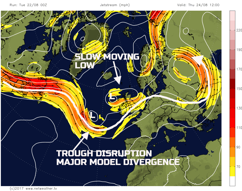
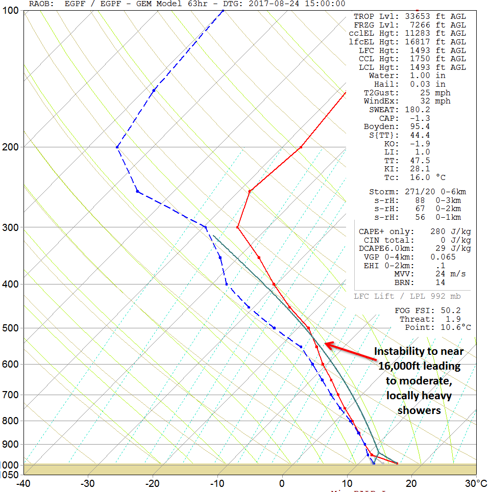
The weather through the course of Thursday will, as a result, be characterised by a convective regime. Some showers are likely to be in evidence already across parts of W Scotland and Ireland first thing, potentially in association with occlusion debris around the slowly filling vortex. Forecast profiles exhibit a distinct N and S divide across the UK, with many central and southern areas of England and Wales, having subsided profiles, when compared with further N. As a result, many southern areas of the British Isles will have a reasonable day on Thursday. Apparently, much cooler and fresher than preceding days, but still pleasantly warm in mainly dry and sunny weather. In contrast though will be further N with moderate or locally heavy showers developing across Scotland, Ireland and N England through the afternoon. The forecast sounding for Glasgow, on Thursday, highlights this unstable profile across the N and supports the idea, from most 00Z models, for a day of sunshine and showers in the N.
Fri 25th Aug: Through into Friday and, overall, all the GM’s are in good agreement for the continued filling vortex to still be slow moving across N areas of the British Isles. The depth of instability is likely to be less on Friday, given a warming of the mid and upper levels, producing less steep lapse rates. However, another day of sunshine and showers will develop across the N. In contrast once again though, will be many central and southern areas of England and Wales where profiles remain subsided and with plenty of dry and fine weather. Bright or sunny spells are likely, and while the air mass over the UK is still markedly cooler than earlier in the week, with light winds and late August sunshine, then it will still be pleasantly warm, especially across urban areas of S England.
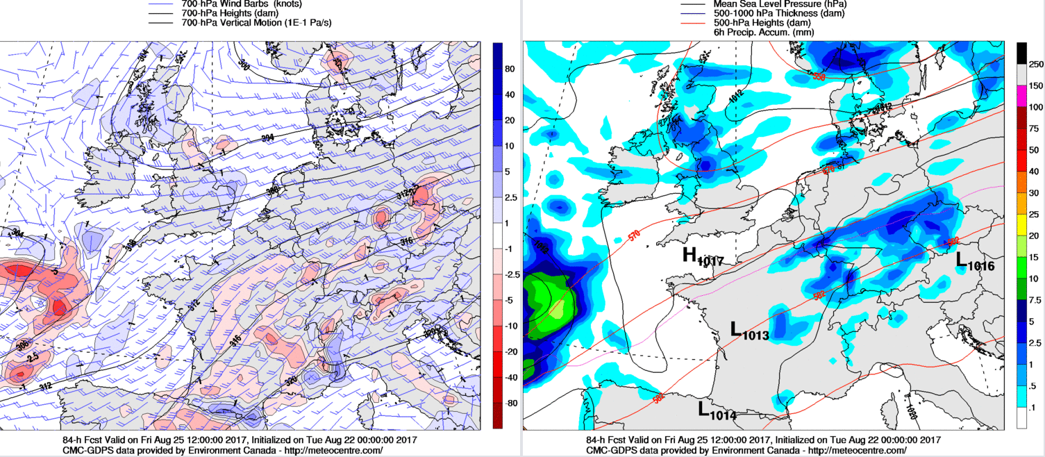
The 00Z GEM model, for now, is an excellent guide as to the expected precipitation distribution through Friday, but there will be a distinct lack of forcing across the British Isles at this point.
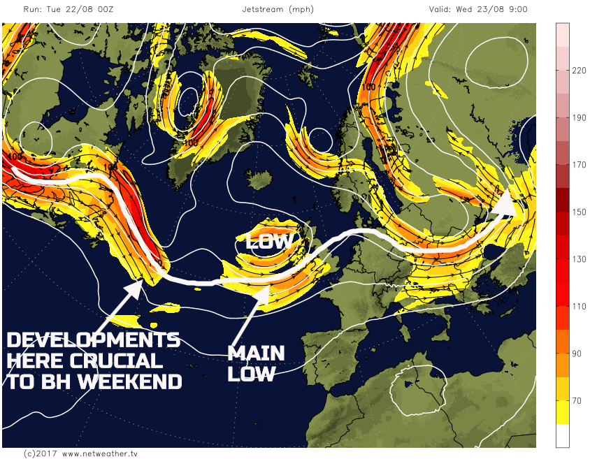
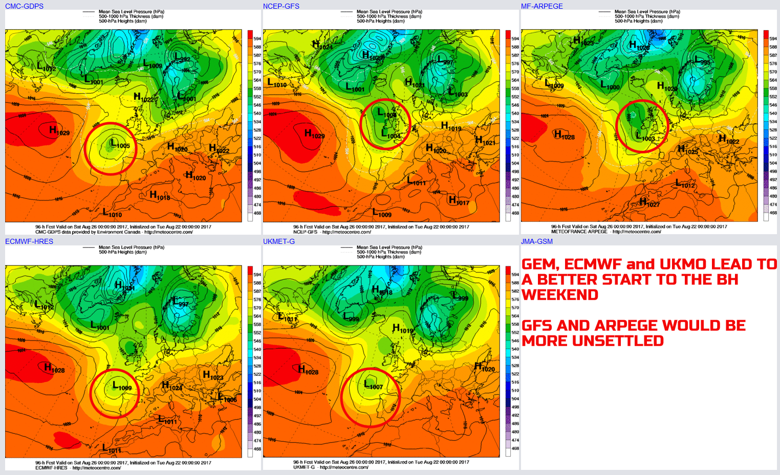
The main uncertainty towards Friday and into the start of the BH Weekend is the interaction, or lack of, of the disrupting upper trough to the SW of the British Isles. There has been a distinct lack of model agreement regarding this development. Focusing on the 00z GFS first and the GFS has been steadfast in not allowing it to disrupt as much as other models, in essence not enabling it to move SE towards Iberia. In stead it holds the vortex just to the SW and, as a result, the overall pattern across much of the British Isles into the BH weekend remains more cyclonic, then anticyclonic.
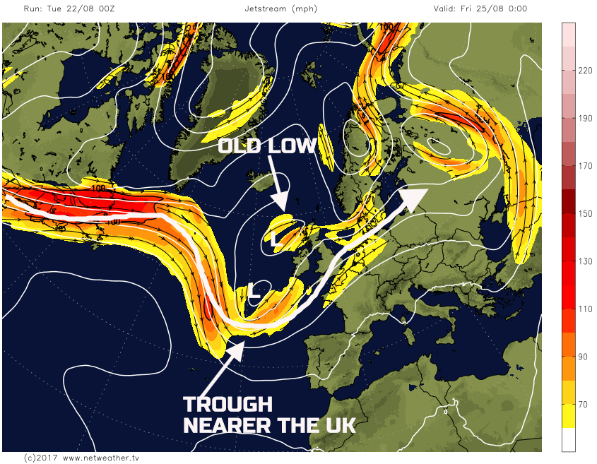
In contrast though are the other GM’s and some of the ENS too. Using the 00Z GM’s as a guide, you’ll see that the likes of the GEM, UKMO and ECMWF all take the vortex down towards NW Iberia. This process then allows the UK to experience a ‘window’ of better weather as Friday comes to an end and we progress into Saturday. However, note both the 00Z GFS and the 00Z ARPEGE models, which keep the vortex closer to the UK, lead to an overall unsettled start to the weekend.
This evolution is particularly complex, and while there is model consistency within each model, there has and continues to be a distinct split in the models over the handling of this particular trough-disruption process and its influence on the UK’s weather by late Friday and into Saturday. If for example, the vortex does drift towards Iberia then the flow may well back enough, on its forward side, to bring a plume of high WBPT air into S and SE England. This development is highly uncertain, but some thermal plume is possible into Saturday.
Sat 26th and Sun 27th Aug: So, we move into the BH weekend with a lot of uncertainty over the forecast, especially the details. At the moment the preferred outcome is that of the ECMWF, UKMO and GEM, along with some ENS support which takes the vortex down towards Iberia and away from the UK to, essentially, means a fair weather day would develop on Saturday across the British Isles. Some scattered showers can’t be ruled out, but otherwise, a dry day is likely with some bright or sunny spells and variable cloud. A chilly start is possible too but given likely light winds and some sunshine then it would be pleasant enough. The alternative solution would be to a much greater risk of showers, perhaps moderate or heavy showers, if the GFS and the ARPEGE models, for example, to come to fruition.
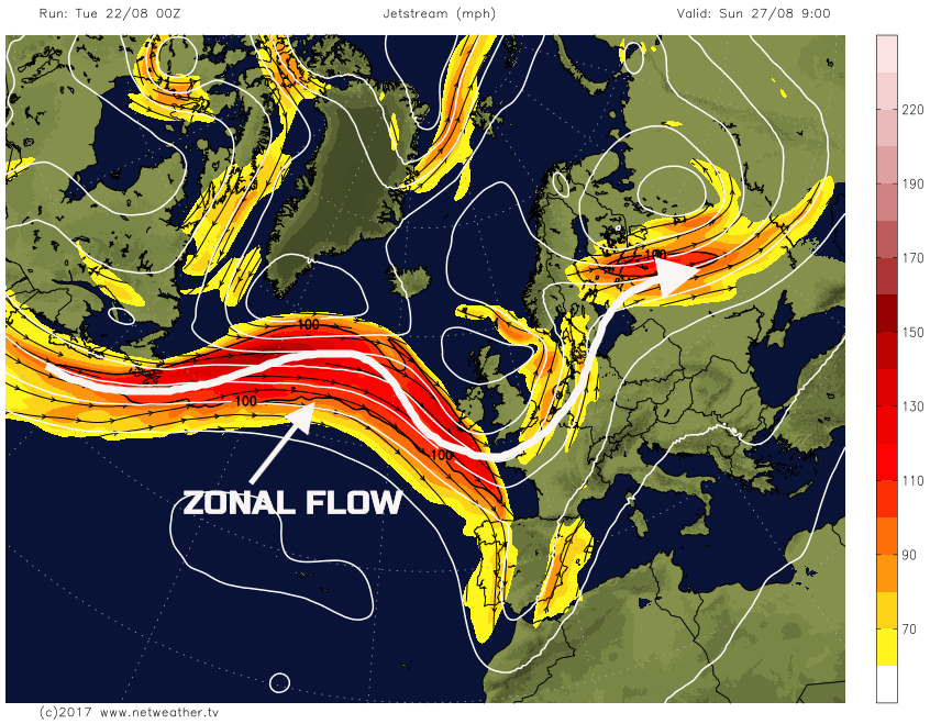
However, regardless of what happens earlier in the BH Weekend, there is some model agreement for a renewed development of a zonal jet exciting out of the NE of the USA and across the N Atlantic. As a result, this means that a return to a more progressive, zonal flow is likely through Sunday and into BH Monday. The details are uncertain at this stage, but one or more cyclonic developments, in association with the jet, are possible leading to an overall deterioration of the weather as the weekend progresses. This event is highlighted well by the 00Z GFS model by 0900Z Sun 27th.
As the BH Weekend progresses all the models, along with ENS support, do show a more cyclonic pattern developing across the N Atlantic and into the UK. There are varying degrees of cyclogenesis in evidence by the T+144hr (00Z Mon 28th), but, as things stand, it is likely that rain and showers, initially across N and W areas by Sunday, will then spread S and E through Monday and beyond.

Medium and Longer Term 28th Aug onwards:
Looking towards and beyond the end of August and the evolution, for now, seems to be a distinctly cyclonic one as we move into the opening autumn month. The summer, as a whole, will no doubt be reviewed in due course and the natural regional variations will also, no doubt, be obvious. However, the summer is likely to come to an end with many summarising it as a poor one, primarily due to the lack of any sustained, nationwide, spells of warm, dry and sunny conditions. It is, overall, low pressure that has been the dominant feature, rather than high pressure for many regions.
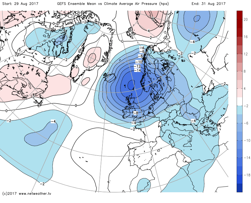
Into late August and early September and, using the 00Z GEFS as a guide, it certainly looks like spells of wind and rain are possible, as low pressure dominates with, currently at least, a particularly negative pressure anomaly signalled across the British Isles to end the month. We’ll keep a close eye on this development and provide more information, if necessary in early September, within an Extended Synoptic Guidance.